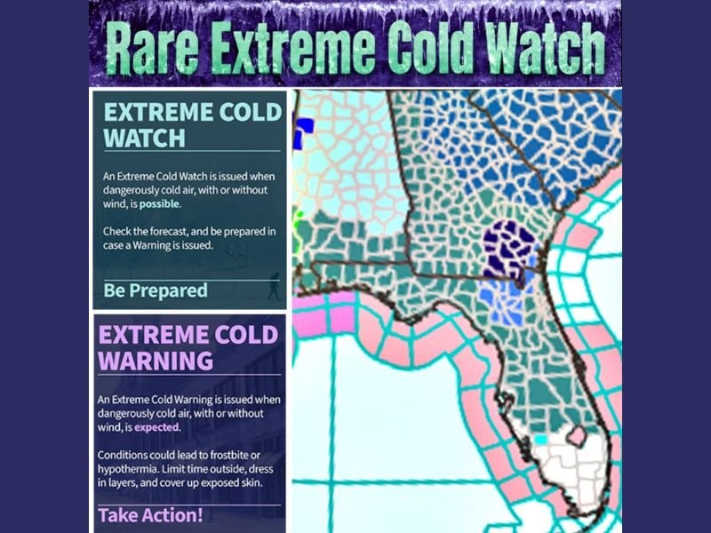
Rare Extreme Cold Watch Issued for Florida as Dangerous Single-Digit Wind Chills Push Deep Into the Peninsula
FLORIDA — A rare Extreme Cold Watch has been issued across large portions of the Southeast, with Florida squarely in the bullseye as dangerously cold air is expected to surge deep into the peninsula, bringing single-digit wind chills to areas unaccustomed to this level of cold.
Why This Extreme Cold Watch Is Unusual for Florida
Extreme Cold Watches are rarely issued in Florida, even during strong winter cold fronts. This alert is reserved for situations where dangerously cold air is possible, with or without strong winds, and where impacts could pose serious risks to life and property.
Forecast guidance shows Arctic air pushing farther south than normal, reinforced by strong winds, creating conditions cold enough to warrant elevated alerts across much of the state.
Wind Chills Expected to Drop Into Single Digits
The most concerning aspect of this setup is wind chill. As strong winds persist behind the cold front, wind chills are expected to plunge into the single digits, even in parts of central and southern Florida.
This level of cold is exceptional for the region and increases the risk of frostbite and hypothermia, especially for anyone spending prolonged time outdoors overnight or during the early morning hours.
Watches Likely to Upgrade to Warnings
Forecasters indicate that many areas currently under an Extreme Cold Watch may be upgraded to Extreme Cold Warnings as confidence increases and timing becomes more certain. A warning is issued when dangerously cold conditions are expected, not just possible.
Residents are urged to take watches seriously now, as upgrades could happen quickly.
Areas Most at Risk Across the Peninsula
The guidance shows the core of the cold reaching well into the Florida peninsula, with interior locations expected to feel the coldest wind chills, while coastal areas experience slightly moderated temperatures but still hazardous conditions due to wind. Even regions that rarely drop below freezing may experience record or near-record cold sensations.
What Residents Should Do to Prepare
This event poses risks not only to people but also to pets, plants, pipes, and infrastructure. Extended exposure to wind-driven cold can cause damage even when air temperatures remain above freezing.
Limiting time outdoors, dressing in layers, covering exposed skin, and ensuring adequate heating are critical steps as conditions deteriorate.
A Serious Cold Event for the Southeast
This is not a typical Florida cold snap. The combination of rare alerts, deep Arctic air, and strong winds makes this a high-impact cold event that deserves attention.
If you received phone alerts or are already feeling unusually cold conditions where you live, share what you’re experiencing. Stay informed with continuing coverage, updates, and safety guidance at CabarrusWeekly.com.