Rare Florida Snow Flurry Signal Emerges as NOAA Flags Low-Probability Overnight Event Near Orlando and Gulf Coast
FLORIDA — A highly unusual winter signal is appearing in NOAA guidance this weekend, showing a low-probability chance of snow flurries across parts of central and west-central Florida late Saturday night into early Sunday morning—something rarely seen in the Sunshine State.
NOAA Highlights Low-Probability but Unprecedented Snow Signal
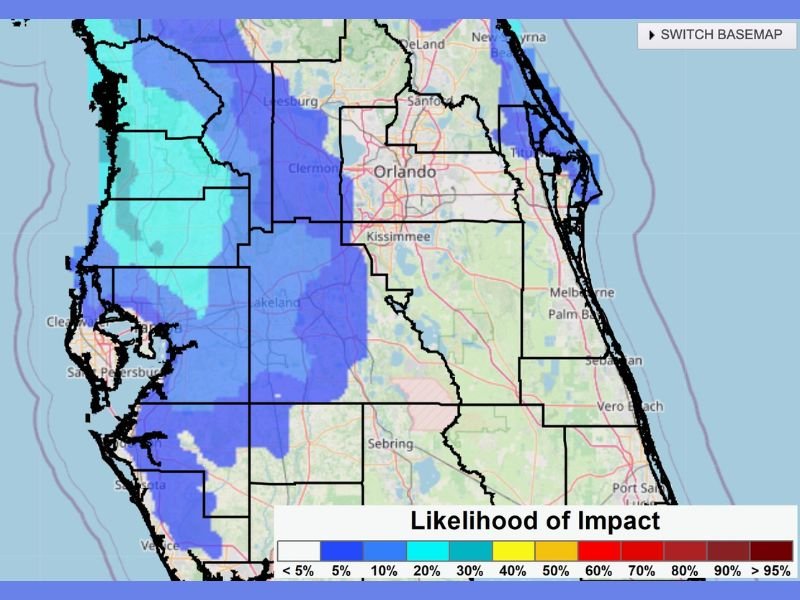
Latest NOAA impact guidance indicates subtle but notable chances of frozen precipitation, with probabilities generally below 20 percent, stretching across portions of west-central and central Florida. While these odds are low, the mere presence of a snow signal is remarkable for a region where winter precipitation is almost always rain.
The setup is being driven by unusually cold air spilling southward, interacting with shallow moisture over the Gulf of Mexico and central peninsula.
Areas Under the Greatest Flurry Watch
The highest relative probabilities—still modest—are focused from the Tampa Bay region through Lakeland and into the Orlando metro area. Locations west of Orlando and closer to the Gulf Coast show slightly higher odds compared to the Atlantic side of the peninsula.
This does not indicate accumulating snow. Instead, forecasters are watching for brief flurries or ice crystals, most likely late Saturday night through early Sunday morning, when surface temperatures are coldest.
Why This Is So Rare for Florida
Snow in Florida requires an exceptional overlap of deep cold air and moisture, something that almost never occurs. Even during historic cold outbreaks, Florida typically remains too dry or too warm aloft for snowflakes to survive to the ground.
That is why long-time residents note they have never seen a forecast like this in decades of living in the state. While most areas will likely see nothing more than cold air, this setup is unusual enough to merit attention.
What Impacts—If Any—Are Expected
Even if flurries occur, no accumulation or travel impacts are expected. Roads will remain unaffected, and any flakes would be short-lived and primarily visual. The bigger story for Florida will be unseasonably cold temperatures, especially overnight, with frost and freeze concerns remaining more impactful than snow itself.
What to Watch Going Forward
Forecasters will continue monitoring whether cold air deepens just enough to support flakes reaching the ground. However, confidence remains low, and many locations will likely see nothing at all.
Still, in a state where snow is nearly unheard of, even a slight chance is enough to spark attention.
If you’re in Florida and notice flurries, unusual ice crystals, or sharply colder-than-normal conditions this weekend, share what you’re seeing. Stay with CabarrusWeekly.com for continued winter weather updates and expert analysis.