Rare Florida Snow Signal? 540 Thickness Line Dips Near Coast as Rain-to-Snow Transition Zone Edges Toward the Southeast
FLORIDA — A striking winter weather signal is emerging along the Southeast coast, as forecast maps show the 540 thickness line — a key atmospheric marker for the rain-to-snow transition — dipping unusually far south toward Florida.
Meteorologists often use the 540 line as a rough guideline for where precipitation can change from rain to snow. When that boundary slides south, it signals colder air filtering into regions that rarely see frozen precipitation.
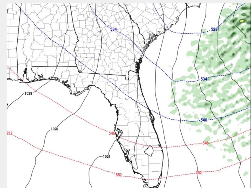
What the 540 Line Means
On the latest forecast map, the blue dashed line labeled 540 arcs across the western Atlantic just off the Florida coastline. North of that boundary, atmospheric conditions become supportive of snow rather than rain.
Thickness values are a measurement of the vertical depth of the atmosphere between two pressure levels. When that measurement falls to around 540 decameters, the air column is typically cold enough to support snow — assuming moisture is present.
In this setup:
- The 540 line runs just offshore of Florida’s east coast
- Lower values (like 534) extend farther north into Georgia and the Carolinas
- Higher thickness values (546 and 552) remain south over the Gulf and southern Florida
This positioning places parts of the Southeast near the critical rain-to-snow threshold.
Could Snow Really Fall Near Florida?
While snowfall in Florida is rare, the setup suggests unusually cold air is pressing deep into the region. If precipitation overlaps with that colder air mass, especially near the 540 boundary offshore, snowflakes could mix in — particularly over open waters.
In fact, forecasters note that cruise ships off Florida’s Atlantic coast could potentially encounter snow if conditions align just right.
However, land-based impacts remain uncertain. Slight shifts in temperature or storm track could mean the difference between cold rain and a brief wintry mix.
Broader Southeast Impacts
Farther north across Georgia and the Carolinas, the colder air is more established. If precipitation reaches inland areas north of the 540 line, snow becomes more likely.
The positioning of the 540 boundary suggests:
- Colder air entrenched across inland Southeast states
- A tight gradient between rain and snow potential
- Sensitivity to small atmospheric shifts
This is a dynamic setup that will require close monitoring.
A Rare Winter Look for the Sunshine State
Florida rarely finds itself near the snow line, making this pattern particularly notable. Even if measurable snowfall does not materialize on land, the southward dip of the 540 thickness line highlights just how far the cold air mass has advanced.
As this system evolves, updates will refine exactly where rain transitions to snow — and whether any flakes can reach areas that almost never see them. For continued coverage of this unusual winter pattern and Southeast forecast updates, stay connected with CabarrusWeekly.com.