Record-Breaking Warmth Before the Storm: Line of Thunderstorms Targets Columbus by Late Morning, Pittsburgh Early Afternoon After May-Like Morning Surge
OHIO VALLEY — Enjoy the summer preview while it lasts. Much of Ohio and western Pennsylvania is waking up to May-like warmth, with temperatures surging toward record highs before a strong line of showers and thunderstorms sweeps through later today.
Forecasters say this morning’s warmth will be short-lived as a well-defined band of storms pushes east across the region.
Morning Warmth Near Record Territory
Temperatures are climbing quickly across:
- Columbus
- Dayton
- Cincinnati
- Akron
- Pittsburgh
Several climate sites are expected to challenge record highs before clouds thicken and storms begin to roll in.
The atmosphere has turned unusually warm and humid for early March, creating the fuel needed for the approaching line of storms.
Current Storm Position
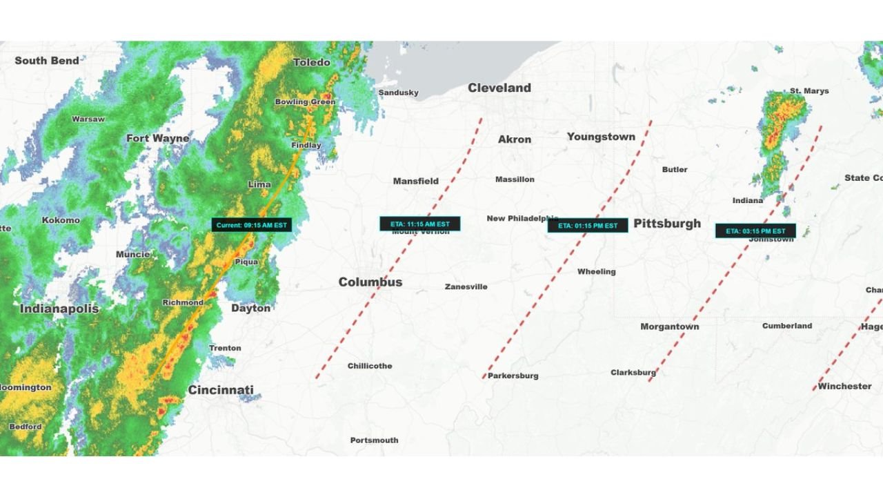
As of mid-morning, a solid line of heavy rain and embedded thunderstorms is advancing eastward from:
- Indianapolis
- Muncie
- Richmond
- Into western Ohio near Dayton and Lima
This line will continue progressing west to east across the state through the late morning and early afternoon hours.
Estimated Arrival Times
Based on the latest projections:
- Columbus area: Around 11:15 AM EST
- Pittsburgh area: Around 1:15 PM EST
- Eastern Ohio into western Pennsylvania: Early to mid-afternoon
- Areas farther east of Pittsburgh: Mid to late afternoon
The line is moving steadily and should maintain its forward speed through the region.
What to Expect With the Storms
While this is not necessarily a widespread severe outbreak, the line is capable of producing:
- Brief heavy downpours
- Gusty winds
- Frequent lightning
The sharp contrast between the warm air ahead of the line and cooler air behind it will help drive storm intensity.
West to East Sweep Across the State
The system will move in a fairly linear fashion:
- Western Ohio late morning
- Central Ohio around midday
- Eastern Ohio early afternoon
- Western Pennsylvania shortly after
Behind the line, temperatures will drop and conditions will stabilize.
Bottom Line
A record-challenging, May-like morning will give way to a line of showers and thunderstorms sweeping west to east across Ohio into western Pennsylvania. Columbus should see storms by late morning, with Pittsburgh following early this afternoon.
Enjoy the warmth early — but keep an eye on the sky as storms approach.
CabarrusWeekly.com will continue tracking the timing and intensity of today’s system as it progresses eastward.