Record Highs Are Crushing Record Lows Across the U.S. Since 2020 — Phoenix, Miami, Austin, and Chicago Show Stunning Temperature Imbalance
UNITED STATES — A striking temperature trend is emerging across major American cities: daily record highs are vastly outnumbering daily record lows since January 1, 2020.
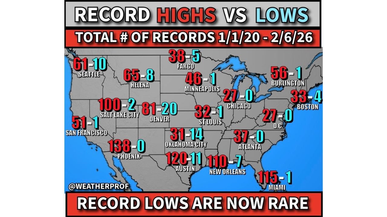
The compiled data, covering January 1, 2020 through February 6, 2026, shows dramatic imbalances in nearly every region of the country — with southern and western cities experiencing the most extreme gaps.
Phoenix and Miami Show the Most Extreme Ratios
Among the most eye-catching examples:
- Phoenix: 138 record highs to 0 record lows
- Miami: 115 record highs to 1 record low
- Austin: 120 record highs to 11 record lows
- New Orleans: 110 record highs to 7 record lows
In a historically stable climate, record highs and record lows tend to occur at roughly similar frequencies over time. Instead, the recent data shows record cold mornings have become rare — particularly in the Sun Belt and desert Southwest.
Phoenix stands out with zero record morning lows in the six-year period analyzed.
The Southeast and Gulf Coast Show Strong Warming Signal
The Gulf Coast region also reflects a pronounced imbalance:
- Atlanta: 37 highs to 0 lows
- Washington, D.C.: 27 highs to 0 lows
- Miami: 115 highs to 1 low
- New Orleans: 110 highs to 7 lows
These figures show record warmth dominating across the Southeast.
Midwest and Northern Cities Also Show Gaps
While northern cities still experience occasional record cold, highs still outpace lows significantly:
- Chicago: 27 highs to 0 lows
- Minneapolis: 46 highs to 1 low
- St. Louis: 32 highs to 1 low
- Fargo: 38 highs to 5 lows
- Denver: 81 highs to 20 lows
Even traditionally cold-weather cities like Minneapolis and Fargo are seeing more record warmth than record cold.
West Coast and Mountain West Reflect Similar Pattern
The western United States follows the same trend:
- Salt Lake City: 100 highs to 2 lows
- Helena: 65 highs to 8 lows
- Seattle: 61 highs to 10 lows
- San Francisco: 51 highs to 1 low
Although some locations in the Northwest show slightly more record lows compared to the South, record highs still significantly outnumber them.
Why This Matters
Climatologically, in a balanced system, the ratio of record highs to record lows would hover near 1-to-1 over extended periods. The persistent skew toward record highs suggests a broader warming influence.
Urban heat island effects may amplify some city-level numbers, but the pattern appears widespread — particularly across the Southwest, Gulf Coast, and Southeast.
The greatest imbalance appears in southern and western cities near the Gulf of Mexico and in desert climates, where dry air and increasing background warmth allow extreme high temperatures to more easily set new records.
Bottom Line
From Phoenix and Austin to Chicago and Miami, record high temperatures are vastly outpacing record lows across the United States since 2020.
Record cold mornings are becoming increasingly rare — especially in the South and West — while record heat continues to accumulate.
As temperature records continue to be rewritten, the imbalance between highs and lows is becoming one of the clearest statistical signals in recent climate data.
For more national weather and climate trend updates, stay with CabarrusWeekly.com.
Author: Cabarrus Weekly Weather Desk | Category: Weather