Rolling Fork Mississippi EF4 Tornado 2023 Mobile Radar Captures Rare Peak Intensity As Violent Storm Tore Through Town
ROLLING FORK, MISSISSIPPI — One of the most destructive tornadoes of 2023 is once again drawing attention after remarkable mobile radar footage captured the storm at peak intensity as it tore directly through Rolling Fork.
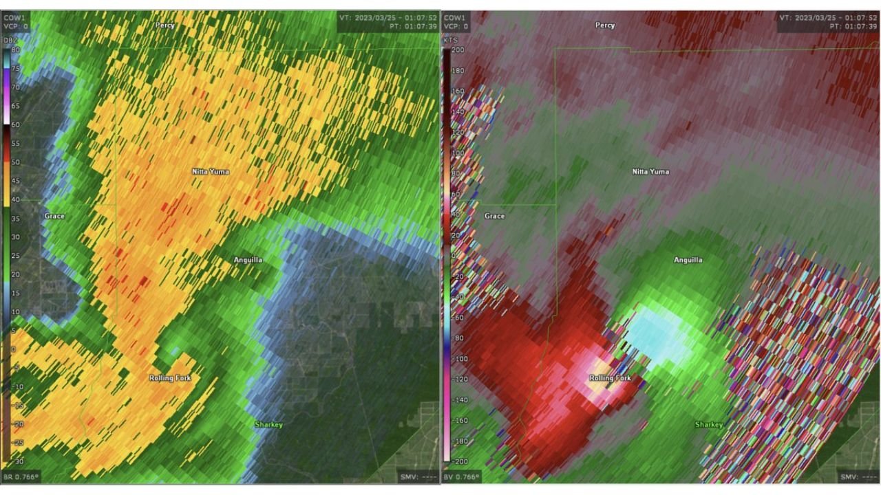
The high-end EF4 tornado, which struck the Mississippi Delta town, was documented in extraordinary detail by a COW1 mobile radar unit, offering one of the clearest looks ever recorded inside a violent tornado.
Radar Captures Tornado At Peak Strength
The radar imagery shows the tornado as it moved through Rolling Fork and surrounding areas including Nitta Yuma, Grace, and Anguilla, revealing a powerful and well-defined circulation.
Key observations from the radar data include:
- A tight, intense velocity couplet, indicating extreme rotational winds
- A clearly defined debris signature, confirming significant destruction on the ground
- Strong reflectivity values surrounding the core, highlighting heavy precipitation wrapping around the tornado
This level of detail is rarely captured, especially directly within a populated area during peak tornado intensity.
One Of The Most Detailed Views Of A Dixie Alley Tornado
The Rolling Fork tornado is widely considered one of the most violent events in recent Dixie Alley history, and this radar capture adds to its significance.
Experts have noted that:
- The data represents some of the most impressive mobile radar observations ever recorded
- It provides a high-resolution look at internal tornado structure, including wind field organization
- The storm maintained strength as it moved directly through town, maximizing damage potential
This type of dataset is crucial for understanding how violent tornadoes behave in real-world conditions.
Tornado Path Through Mississippi Delta
The tornado carved a devastating path through:
- Rolling Fork, Mississippi
- Nearby communities including Anguilla and Nitta Yuma
As the storm tracked across the region, radar indicated:
- Sustained intense rotation over multiple scan cycles
- Rapid forward motion combined with strong inflow
- A broad area of destructive winds surrounding the core circulation
These factors contributed to the widespread destruction reported across the area.
Why This Radar Capture Matters
Mobile radar systems like COW1 are designed to get closer to storms than traditional radar, providing:
- Finer-scale resolution of wind speeds and structure
- Better detection of debris and near-ground rotation
- Insights into how tornadoes evolve in real time
In this case, the data captured during the Rolling Fork event is being viewed as benchmark-level evidence of violent tornado dynamics.
A Reminder Of Tornado Power
The Rolling Fork EF4 tornado remains a stark reminder of how quickly conditions can escalate during severe weather events, especially in regions like Mississippi that are prone to nighttime and rain-wrapped tornadoes.
The radar imagery underscores:
- The extreme intensity tornadoes can reach
- How rapidly they can impact populated areas
- The importance of early warnings and preparedness
Final Word
The 2023 Rolling Fork, Mississippi EF4 tornado stands out not only for its destruction but also for the rare and detailed radar data captured during its peak intensity.
As severe weather season continues across the United States, this event serves as both a scientific milestone and a powerful reminder of the need to stay alert when storms develop.
Stay with CabarrusWeekly.com for more in-depth weather analysis and updates.