Santa Ana Winds Set to Roar Across Southern California With 60 MPH Gusts and Unseasonable Heat Through Thursday
SOUTHERN CALIFORNIA — A period of moderate but impactful Santa Ana winds is expected to affect Southern California from Tuesday through Thursday, bringing powerful northeast wind gusts, unusually warm temperatures, and localized fire concerns across several well-known wind-prone corridors.
Forecasters say the setup favors classic Santa Ana wind behavior, with the strongest impacts focused in mountainous and coastal transition zones.
Strongest Wind Corridors and Peak Gusts
The highest probability for damaging wind gusts between 50 and 60 mph is expected in:
- San Gabriel Mountains
- Santa Monica Mountains
- Oxnard and Camarillo Plain
- Inland passes near Riverside and areas approaching Joshua Tree National Park
Widespread gusts of 30–40 mph are likely across much of Los Angeles, Long Beach, Oceanside, San Diego, and surrounding inland valleys, especially during overnight and morning hours when Santa Ana winds typically peak.
Timing: Tuesday Through Thursday
The Santa Ana event is expected to:
- Begin Tuesday, increasing rapidly overnight
- Persist through Wednesday, with the strongest gusts
- Gradually ease Thursday, though breezy conditions may linger
Wind direction will be primarily east to northeast, a key signature of Santa Ana conditions that enhances downslope acceleration and drying.
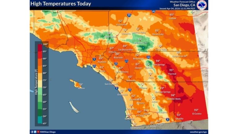
Temperatures Soar Into the 80s and 90s
Alongside the winds, temperatures will climb well above seasonal averages, with highs reaching:
- Upper 80s to low 90s in inland valleys
- 80s near the coast, even in typically cooler beach communities
This combination of heat and wind is unusual for winter and increases stress on vegetation.
Fire Risk Elevated but Not Extreme
While the fire risk remains on the lower side, meteorologists stress it is not zero. Dry offshore winds, warm temperatures, and gusty conditions can still support:
- Rapid fire spread if ignition occurs
- Increased danger near brush-heavy foothills and canyons
- Higher risk during peak wind hours
Residents in wind-prone areas are urged to avoid outdoor burning and secure loose items.
What Residents Should Prepare For
Southern California residents should expect:
- Strong, potentially damaging wind gusts
- Difficult driving conditions, especially for high-profile vehicles
- Unseasonably hot afternoons
- Localized power disruptions in the strongest wind zones
Cabarrus Weekly will continue monitoring Santa Ana wind trends and will provide updates if fire conditions or wind forecasts escalate later this week.
