Sea Breeze Storms Fire Up Along Florida’s West Coast From Tampa to Naples, Heavy Downpours and Lightning Likely Near I-75 Corridor
FLORIDA — A classic summer-style sea breeze setup is unfolding across the Sunshine State today, with thunderstorms developing along the west coast and clustering near the Interstate 75 corridor from the Tampa Bay region south toward Naples.
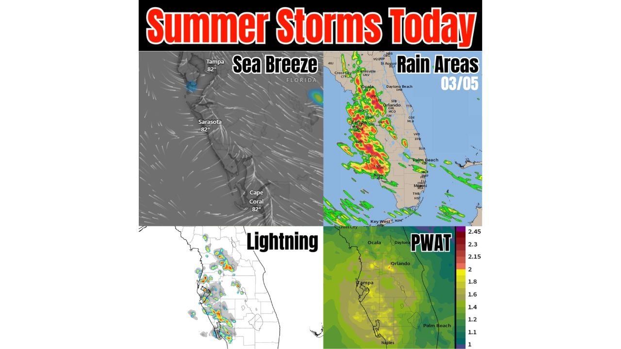
Forecast analysis shows a familiar Florida pattern: light background winds allowing sea breeze boundaries to collide inland during the afternoon hours, triggering scattered to numerous showers and thunderstorms.
Storm Focus: West Coast Sea Breeze Collision
Wind flow imagery highlights onshore flow pushing inland from the Gulf Coast, with convergence zones forming near:
- Tampa
- Sarasota
- Cape Coral
- Inland toward Ocala
- South through Naples
This type of boundary collision is commonly seen during Florida’s warm season and frequently sparks slow-moving thunderstorms near or just east of I-75.
Rain Areas Cluster Along Central and Southwest Florida
Radar projections show clustered storm development extending from:
- Ocala
- Through the Orlando region
- Southward toward Fort Myers (RSW area)
- Down toward Naples
Heavier cores appear embedded within broader rain areas, suggesting pockets of intense rainfall.
With storms expected to move slowly due to weak steering flow, localized downpours could quickly accumulate rainfall in areas where cells repeatedly develop.
Lightning and Thunderheads Already Developing
Lightning analysis shows multiple active thunderstorm cells along the west-central Florida coastline and inland toward the I-75 corridor.
These storms exhibit classic “thunderhead” signatures, with vertically developed cells capable of:
- Frequent lightning
- Brief torrential rainfall
- Gusty outflow winds
High PWAT Values Signal Moist Atmosphere
Precipitable Water (PWAT) values across central and southern Florida are elevated, indicating a very moist air mass in place.
Higher PWAT values typically support:
- Efficient rainfall production
- Slow-moving, heavy rain storms
- Stronger updraft potential in deeper moisture
This environment may even allow for isolated small hail in the stronger storm cores, particularly where updrafts intensify.
Slow Storm Motion Increases Localized Impact Risk
Flow patterns suggest limited overall movement once storms develop. That means:
- Cells may linger over the same areas
- Rainfall could become locally heavy
- Street flooding is possible in poor drainage zones
Communities near Tampa, Sarasota, Cape Coral, Fort Myers, Ocala, and Naples should monitor radar closely through the afternoon and early evening.
Classic Florida Afternoon Setup
Today’s weather pattern reflects a textbook Florida warm-season scenario:
- Sea breeze boundary formation
- Boundary collisions inland
- Deep tropical moisture
- Slow-moving convection
While not necessarily severe on a widespread scale, storms could still pack heavy rain, frequent lightning, and isolated stronger cells.
CabarrusWeekly.com will continue monitoring storm development across Florida as the afternoon progresses. Residents along the west coast and near the I-75 corridor should remain weather-aware and prepared for rapidly changing conditions.