Severe Thunderstorm Watch Issued for Cabarrus and Charlotte Region as Storms With 70 MPH Winds Move Into North Carolina
CABARRUS COUNTY, NORTH CAROLINA — A Severe Thunderstorm Watch has been issued for much of western and central North Carolina, including Cabarrus County and the Charlotte region, until 11 a.m. Monday as a line of strong storms pushes east across the state.
Forecasters say the primary threat from the approaching storms will be scattered damaging wind gusts that could reach up to 70 mph, though meteorologists note that an isolated tornado cannot be ruled out as the system moves through the area.
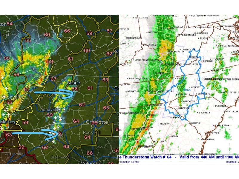
The storms were already moving through portions of the North Carolina mountains early Monday morning, with radar showing a strengthening line of thunderstorms tracking east toward the Foothills and the greater Charlotte metro area.
Storms Moving From Mountains Toward the Charlotte Region
Weather radar shows a band of storms stretching from Tennessee into western North Carolina, with lightning and heavy rain already affecting areas near Knoxville and Asheville before advancing eastward.
Meteorologists expect the storm line to continue pushing toward the Charlotte metro area and surrounding counties, including Cabarrus, during the morning hours. As the storms move east, residents may experience sudden bursts of heavy rain, strong wind gusts, and frequent lightning, particularly as the strongest part of the line approaches.
Cabarrus County Included in the Watch Area
Cabarrus County is among dozens of counties included in the Severe Thunderstorm Watch issued for western and central North Carolina.
Other counties included in the watch area include:
- Alexander
- Alleghany
- Ashe
- Avery
- Buncombe
- Burke
- Cabarrus
- Caldwell
- Catawba
- Cleveland
- Davie
- Gaston
- Haywood
- Henderson
- Iredell
- Lincoln
- McDowell
- Mecklenburg
- Mitchell
- Polk
- Rowan
- Rutherford
- Union
- Watauga
- Wilkes
- Yadkin
- and several additional counties across the mountains and foothills.
The watch area stretches from the North Carolina mountains eastward toward the Charlotte metropolitan region, covering a large portion of western and central parts of the state.
What a Severe Thunderstorm Watch Means
A Severe Thunderstorm Watch means that atmospheric conditions are favorable for storms capable of producing damaging winds, hail, or isolated tornadoes.
While a watch does not guarantee that severe weather will occur in every location, it indicates that storms capable of becoming dangerous could develop quickly.
Forecasters advise residents across the watch area to stay alert for weather updates, warnings, and rapidly changing conditions as the storm system moves through.
Morning Storm Line Could Bring Strong Wind Gusts
Meteorologists say the main hazard from the current storm system will likely be powerful wind gusts capable of bringing down trees or power lines, particularly in areas where storms intensify. Localized flooding could also occur where heavy rain falls in a short period of time.
With storms expected to move through the region during the morning hours, commuters across Cabarrus County and the Charlotte area may encounter reduced visibility, wet roads, and gusty winds.
Residents are encouraged to monitor weather alerts and remain prepared for possible severe thunderstorm warnings as the storms continue moving across North Carolina. Stay with CabarrusWeekly.com for the latest severe weather updates affecting Cabarrus County and the greater Charlotte region.