Severe Weather Corridor Expands from Texas to the Midwest on Friday, March 6 as Oklahoma, Missouri, Iowa and Illinois Face Elevated Storm Risk
UNITED STATES — A broad corridor of severe weather potential is expected to develop Friday, March 6, 2026, stretching from Texas northward through Oklahoma, Missouri, Iowa and into parts of Illinois and southern Wisconsin.
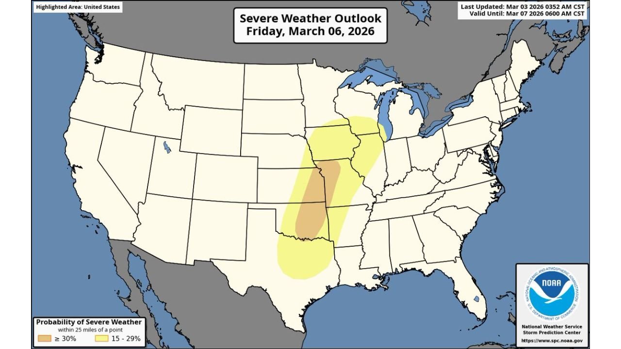
The latest severe weather outlook highlights a concentrated zone of higher probabilities centered from central Oklahoma through eastern Kansas and into Missouri, with surrounding areas also under a lower — but notable — severe risk.
Core Risk Area: Oklahoma to Missouri
The darker shaded zone on the outlook map indicates the highest probabilities of severe storms within 25 miles of any given point. This corridor runs roughly:
- From central and eastern Oklahoma
- Through eastern Kansas
- Into western and central Missouri
Cities that could fall within or near this higher-risk axis include:
- Oklahoma City
- Tulsa
- Wichita
- Kansas City
- Springfield, Missouri
This region sits beneath the most favorable overlap of instability, wind shear and lift needed to produce organized severe thunderstorms.
Surrounding Risk: Texas to the Upper Midwest
A broader, lighter-shaded risk area expands:
- South into north Texas
- North into Iowa
- East into Illinois
- Near southern portions of Wisconsin
This indicates that severe storms may not be confined to one narrow zone but could develop across a large portion of the central United States.
What the Probabilities Mean
The outlook shows:
- A central corridor with 30% or greater probability of severe weather within 25 miles of a point.
- Surrounding areas with 15–29% probability.
Those values suggest scattered to numerous severe thunderstorms are possible within the highlighted region.
While specific hazards are not detailed in the graphic alone, setups like this typically bring risks such as:
- Damaging wind gusts
- Large hail
- Possible tornadoes
Storm mode and timing will determine which hazards become dominant.
Expanding Spring Pattern Across the Plains
This Friday setup follows an already active pattern earlier in the week across the southern Plains. As energy lifts northeastward, the severe corridor shifts toward the Mid-Mississippi Valley and into parts of the Midwest.
This northward expansion is common in early March as winter systems transition into more spring-like severe weather patterns.
Why Cabarrus County Should Pay Attention
Although this severe weather threat is centered well west of North Carolina, storms that develop in the Plains and Midwest often track eastward in the following days.
Pattern shifts that bring severe weather to Oklahoma and Missouri can later influence:
- The Tennessee Valley
- The Deep South
- Eventually parts of the Southeast
Cabarrus County residents are encouraged to monitor future outlooks as storm systems evolve.
CabarrusWeekly.com will continue providing updates on significant national weather threats that may shape regional conditions in the days ahead.