Shallow Arctic Air and Gulf Moisture Set the Stage for a High-Impact Winter Storm From Texas Through Alabama and the Carolinas This Weekend
UNITED STATES — Global forecast models remain remarkably consistent in signaling a potentially high-impact winter storm from late Friday night through Sunday, stretching from Texas across the Deep South and into the Carolinas, as shallow Arctic air undercuts deep Gulf moisture.
Why This Setup Is Especially Dangerous
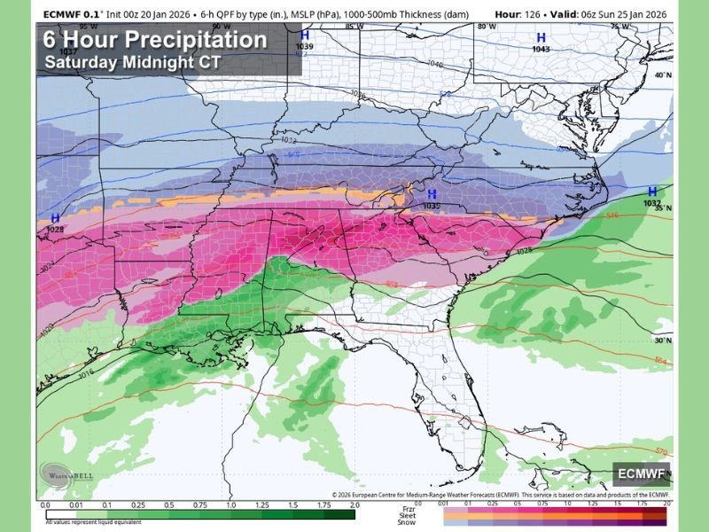
This storm is driven by a classic Southern winter weather pattern, where cold air remains shallow near the surface while warmer, moisture-rich air rides overhead. That profile strongly favors freezing rain and sleet, particularly south of primary snow bands, increasing the risk of ice accumulation, power outages, and prolonged travel impacts.
Snow Most Likely Across the Tennessee Valley
The highest snow potential is focused across the Tennessee Valley, especially north of the Tennessee River, where snow accumulations in the 2 to 4 inch range appear possible. Some localized areas could see higher totals, depending on how quickly colder air deepens during the event.
In these zones, impacts would mainly involve snow-covered roads and isolated power outages, rather than widespread infrastructure damage.
Ice Threat Grows South of the Tennessee River
South of the Tennessee River, forecast confidence increases for an extended period of freezing rain, where rain falls as liquid but freezes on contact with roads, trees, bridges, and power lines. Global models continue to advertise the potential for significant ice accumulation, which poses the greatest concern for long-duration power outages and extremely hazardous travel conditions.
This type of ice event is often more disruptive than snow, particularly in areas not accustomed to prolonged freezing rain.
Southern Edge of the Ice Zone Remains Uncertain
Defining how far south the ice threat extends remains the most challenging part of this forecast. At this time, some ice accumulation is possible as far south as Livingston, Greensboro, Clanton, Lake Martin, and Opelika, though this boundary is highly sensitive to small temperature changes.
The difference between cold rain and crippling ice may shift north or south as the event unfolds.
Timeline: When Impacts Begin and End
The risk of snow and ice may begin as early as midnight Friday night across northwest Alabama, then spread east and south through Saturday and Saturday night. Precipitation could linger well into Sunday, finally tapering off Sunday night, prolonging impacts across multiple states.
South Alabama Likely Avoids Winter Impacts
While much of the Southeast faces winter weather risks, south Alabama is expected to see mainly cold rain, remaining just warm enough to avoid ice accumulation. Even so, temperatures will be cooler than normal.
Widespread Regional Impact Expected
This storm has the potential to affect a very broad area, stretching from Texas through Alabama, Georgia, and into the Carolinas. Forecast confidence is high that travel disruptions will be widespread, regardless of whether precipitation falls as snow or ice.
What Comes Next and How to Prepare
More precise accumulation forecasts are expected over the next 24 to 48 hours, with detailed impact guidance by Thursday. For residents across northern Alabama and adjacent regions, planning now for difficult travel and possible power outages is considered the least-regret option.
The best-case scenario is mostly cold rain. The worst-case scenario is a crippling ice storm capable of causing outages lasting days or longer in isolated areas.
If you are within the potential impact zone, now is the time to review travel plans, prepare for power disruptions, and monitor updates closely. Share what you’re seeing in your area and stay informed with continuing coverage at CabarrusWeekly.com.