Significant Tornado Risk Targets Mississippi and Western Alabama Near 850mb Jet Core as Long-Track Supercells Possible
NORTH CAROLINA — A volatile severe weather setup is unfolding across parts of the Deep South today, with the greatest tornado risk centered near the nose of a strengthening 850mb jet across Mississippi and western Alabama.
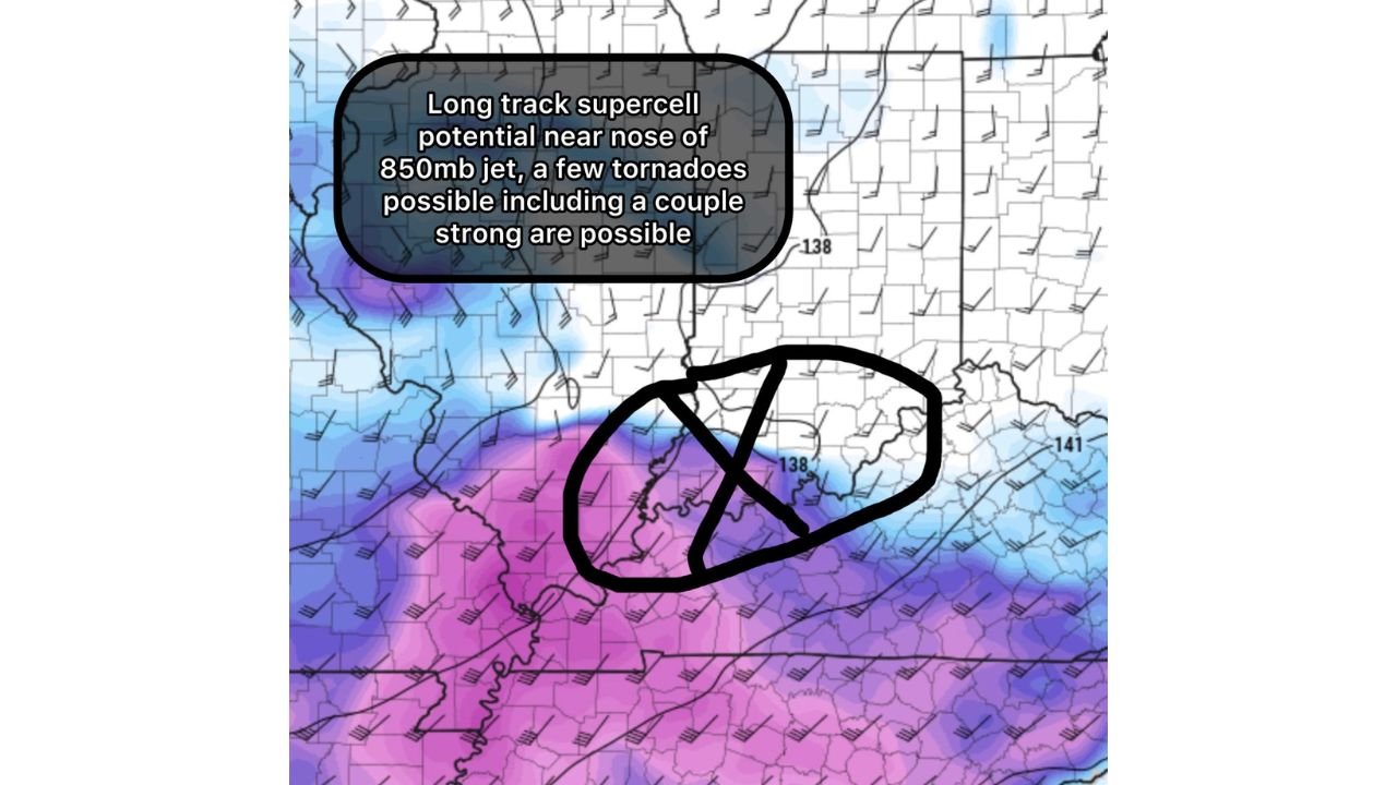
Long-Track Supercell Potential Near the 850mb Jet
Model guidance highlights a corridor of enhanced low-level wind fields stretching from central Mississippi into western and north-central Alabama. This region lies directly beneath the nose of the 850mb jet, a zone where low-level winds accelerate and directional shear increases.
The setup supports long-track supercell potential, particularly where surface instability overlaps with stronger low-level wind profiles. While 0–1 km shear values appear somewhat modest for late winter standards, strong speed shear and favorable low-level thermodynamics may compensate.
Forecasters indicate that a few tornadoes are possible, including a couple that could be strong if storms remain discrete and organized.
Mississippi and Alabama in the Primary Risk Zone
The highest concern appears focused near:
Central Mississippi including areas east of Jackson
Western Alabama including Tuscaloosa and surrounding counties
North-central Alabama approaching the Birmingham region
Wind barbs and shaded fields in the analysis show a clear gradient, with stronger low-level winds pushing north and east through this corridor. That enhanced wind field increases storm-relative helicity, especially along and just north of the warm sector boundary.
This environment favors supercells capable of producing damaging winds, large hail, and tornadoes, particularly during peak heating hours.
0–1 Shear Modest, But Speed Shear Compensates
One of the more nuanced aspects of this setup is that traditional low-level shear values are not exceptionally high for February. However, stronger speed shear through the lowest several thousand feet of the atmosphere may offset that limitation.
When combined with favorable moisture return and a strengthening low-level jet, storms may still rotate efficiently despite less-than-ideal directional shear.
That makes this a conditional but potentially impactful event.
Why This Matters for North Carolina
While the immediate tornado threat remains confined to Mississippi and Alabama, the broader atmospheric pattern is relevant to the Carolinas.
As this system advances eastward, North Carolina may experience:
Increasing rain chances behind the primary severe corridor
Gusty winds along frontal passage
A cooler air mass filtering in after the system exits
There is currently no indication of significant tornado activity for Cabarrus County from this particular setup. However, strong systems moving through the Deep South often bring unsettled weather eastward within 24 to 48 hours.
Monitoring Storm Evolution Through the Evening
The key factors to watch will be:
Storm mode — discrete supercells vs. clustered convection
Placement of the low-level jet maximum
Interaction with any lingering boundaries
If storms remain isolated within the enhanced jet zone, the risk for a couple of significant tornadoes increases. If storms merge into lines more quickly, damaging winds could become the dominant threat.
Residents in the Deep South should remain weather aware, while North Carolina continues to monitor downstream impacts from this evolving system.
We will provide further updates as conditions develop. Stay informed and share local weather reports with us at CabarrusWeekly.com.