Six Tornado Warnings Active in Central Louisiana as Dangerous Nighttime Storms Target Alexandria and Baton Rouge, Threat May Rebuild Toward Georgia and Florida Sunday
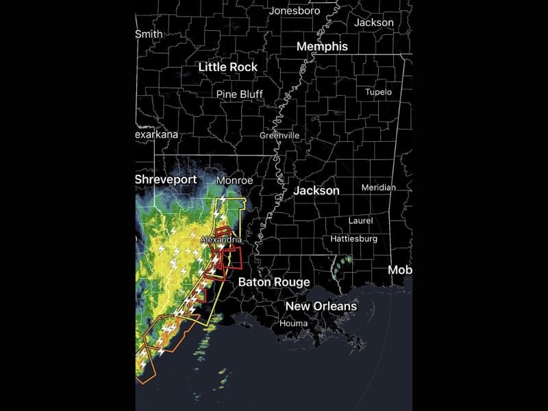
LOUISIANA — A dangerous round of nighttime severe weather is unfolding across central parts of the state, where six tornado warnings were active at 10:15 PM, along with additional severe thunderstorm warnings.
Radar imagery shows a powerful line of storms stretching from near the Gulf Coast northward through central Louisiana, with the most intense activity focused around Alexandria and extending south toward Baton Rouge. Multiple warning polygons indicate ongoing rotation embedded within the squall line.
Alexandria at the Center of the Overnight Tornado Threat
The strongest radar signatures are concentrated near Alexandria, where multiple tornado warnings have been issued. Storms in this corridor are producing intense lightning, heavy rainfall, and embedded rotation capable of brief tornadoes.
The line extends southwest toward coastal Louisiana and northeast toward Monroe, forming a well-organized band of severe weather pushing eastward. Nighttime tornado setups are particularly concerning because visibility is limited and many residents may already be asleep. Warnings can be harder to respond to quickly, increasing overall risk.
Baton Rouge in the Path as Line Pushes East
As the squall line advances, communities including Baton Rouge are directly in the projected path. Additional warning boxes near and south of Alexandria suggest ongoing rotation that could continue as the system tracks east.
The radar presentation shows a solid line of storms from southwest Louisiana up through central sections of the state, with the potential for damaging winds, heavy rain, and brief tornado spin-ups. Given the number of active warnings at this hour, this is not an isolated storm environment but a broader organized severe weather event.
Southern Mississippi and the Gulf Coast Next
Although the most intense activity is currently in central Louisiana, the line is gradually advancing east toward southern Mississippi, including areas that could eventually include cities such as Jackson and Hattiesburg if the storms maintain strength.
Storm motion suggests impacts will continue spreading eastward overnight, with warnings likely to shift accordingly as the system progresses.
Carolinas Face Cold Rain, But Risk Rebuilds Farther South
Behind this severe line, conditions across the Carolinas are expected to trend toward cold rain, rather than significant severe weather.
However, forecasters indicate that as the system shifts east and interacts with warmer air, the severe potential could ramp back up Sunday afternoon and evening across south Georgia and Florida.
That means while Louisiana is dealing with the immediate tornado threat overnight, the broader weather pattern remains active across the Southeast heading into Sunday.
Why Nighttime Severe Weather Is More Dangerous
Nighttime severe weather events carry heightened risk because tornadoes can be rain-wrapped and difficult to see. With darkness reducing visibility and many residents indoors, response time becomes critical.
The combination of six active tornado warnings, additional severe thunderstorm warnings, and a solid eastward-moving squall line underscores the seriousness of this setup.
Residents in central Louisiana, particularly around Alexandria and Baton Rouge, should remain weather aware and have multiple ways to receive alerts overnight.
If you are experiencing severe weather in Louisiana or along the Gulf Coast, share your conditions and updates with CabarrusWeekly.com so others can stay informed as this dangerous storm system continues moving east.