Sleet Falls Instead of Snow Across North Jersey and Northeast Pennsylvania as Forecast Models Miss Early-Morning Precipitation Type
NORTHEAST PENNSYLVANIA — A short-term precipitation forecast surprise unfolded Tuesday morning as sleet began falling across parts of north New Jersey and northeast Pennsylvania, even though short-range models had projected mainly snow.
Real-time public reports indicate sleet mixing in or dominating in areas including:
- Scranton
- Wilkes-Barre
- Hazleton
- Allentown
- Portions of northern New Jersey near Vernon and Sparta
- Areas west of New York City
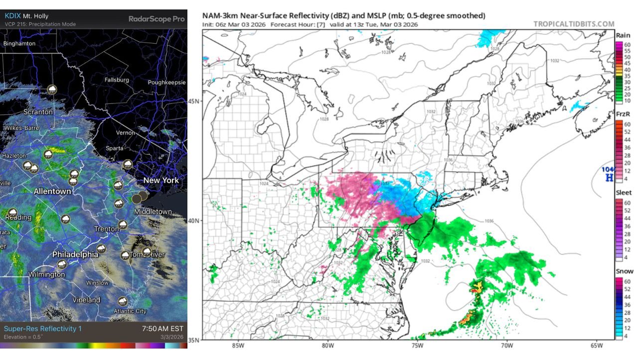
Radar imagery around 7:50 AM EST (March 3, 2026) showed widespread precipitation spreading across eastern Pennsylvania and northern New Jersey.
Models Forecast Snow — Observations Show Sleet
High-resolution models such as the HRRR and NAM had suggested precipitation would fall primarily as snow across northeast Pennsylvania and north Jersey.
However, mPING public observation reports show sleet being observed in multiple communities, indicating a temporary mismatch between model expectations and real-world conditions.
This type of short-term forecast bust typically occurs when a shallow warm layer aloft is slightly stronger than anticipated.
Warm Layer Aloft Driving the Sleet
Model soundings indicate that temperatures above the surface are only marginally above freezing.
When snowflakes fall through that shallow warm layer:
- They partially melt.
- Refreeze before reaching the ground.
- Arrive as sleet instead of snow.
Because the warm layer is marginal, heavier and more sustained precipitation could cool the atmosphere enough to allow a transition back to snow.
Changeover to Snow Possible in Next 1–2 Hours
Given the marginal thermal profile, forecasters expect that:
- Intensifying precipitation rates
- Continued evaporative cooling
- Strengthening lift
may help shift sleet back to snow across northeast Pennsylvania and north Jersey within the next one to two hours.
Areas most likely to see this transition include:
- Scranton
- Wilkes-Barre
- Allentown
- Higher elevations of northern New Jersey
Impacts on Roads and Travel
Sleet can create different travel hazards compared to snow:
- Pellets compact quickly on untreated surfaces.
- Roadways may become icy faster.
- Accumulation can be dense and slick.
If a changeover to snow occurs, accumulation rates could increase depending on intensity.
Why This Matters Beyond the Northeast
While this event is centered in the Northeast, precipitation-type shifts are common in transitional winter systems — a scenario familiar to North Carolina residents during borderline cold events.
Cabarrus County often experiences similar setups where shallow warm layers determine whether precipitation falls as sleet, freezing rain, or snow.
CabarrusWeekly.com will continue tracking winter weather developments nationwide and monitor how evolving storm systems may influence conditions closer to home.