Snow Spreads Across Western Colorado as Storm Tracks West to East, With Mountains Favored for Heaviest Totals
COLORADO — A fast-moving storm system is sweeping across the state from west to east today, bringing accumulating snow to the Western Slope and mountain regions before more scattered showers develop along the Front Range and eastern plains.
Snow is already underway across western Colorado early Friday, with precipitation expected to spread eastward through the mountains during the morning hours.
Western Slope and Mountain Areas See Bulk of Snow
The majority of this system’s energy will be absorbed along and west of the Continental Divide, favoring the higher elevations for the most significant accumulations.
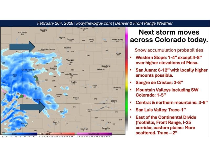
Projected snowfall totals include:
- Western Slope: 1–4 inches, with 4–8 inches possible over higher elevations of Mesa County
- San Juan Mountains: 6–12 inches, with locally higher totals possible
- Sangre de Cristo Range: 3–8 inches
- Central and Northern Mountains: 3–6 inches
- Mountain valleys including southwest Colorado: 1–5 inches
- San Luis Valley: Trace to 1 inch
Communities near Durango, Telluride, Silverton, and other San Juan locations are likely to see the heaviest snow from this system.
Scattered Showers Develop East of the Divide
East of the Continental Divide — including the foothills, Front Range, I-25 corridor, and eastern plains — precipitation is expected to be more hit-or-miss.
Light snow showers may begin developing around midday and continue through the afternoon and evening. Accumulations in these areas are expected to remain limited:
- Trace to 2 inches possible in isolated heavier bursts
Areas including Denver, Colorado Springs, Fort Collins, and Pueblo may see passing snow showers, but widespread accumulation is not anticipated.
Snow May Reach Into Wyoming and Nebraska Panhandle
Light snowfall could extend northward as far as the I-80 corridor in Wyoming and into the western Nebraska Panhandle, where light accumulations are possible. However, the storm’s primary focus remains the Colorado mountains and Western Slope.
Showers Exit by Saturday Morning
Precipitation is expected to taper off quickly by Saturday morning as the system moves east and a ridge of high pressure builds temporarily behind it.
That setup should deliver a drier weekend across much of Colorado before another potential pattern change develops around the middle of next week.
Travel Impacts Likely in Mountain Corridors
Drivers traveling through high mountain passes should prepare for winter driving conditions, especially in:
- San Juan Mountains
- Central mountain corridors
- Higher elevations along the Western Slope
Even modest snow totals can create slick roadways during active snowfall periods.
While this storm is not expected to bring widespread major impacts east of the mountains, localized heavier showers could briefly reduce visibility.
Cabarrus Weekly will continue monitoring national weather systems and their broader impacts as late winter patterns remain active across the western United States.