Snowflakes Reported Across West-Central Florida as Rare Early-Morning Flurries Appear Near Tampa Bay
FLORIDA — Reports of snowflakes falling across parts of West-Central Florida early this morning are drawing widespread attention, as radar data and surface observations suggest a rare flurry event unfolding near the Tampa Bay region during an intense Arctic air intrusion.
Snowflake Reports Centered Around Tampa Bay
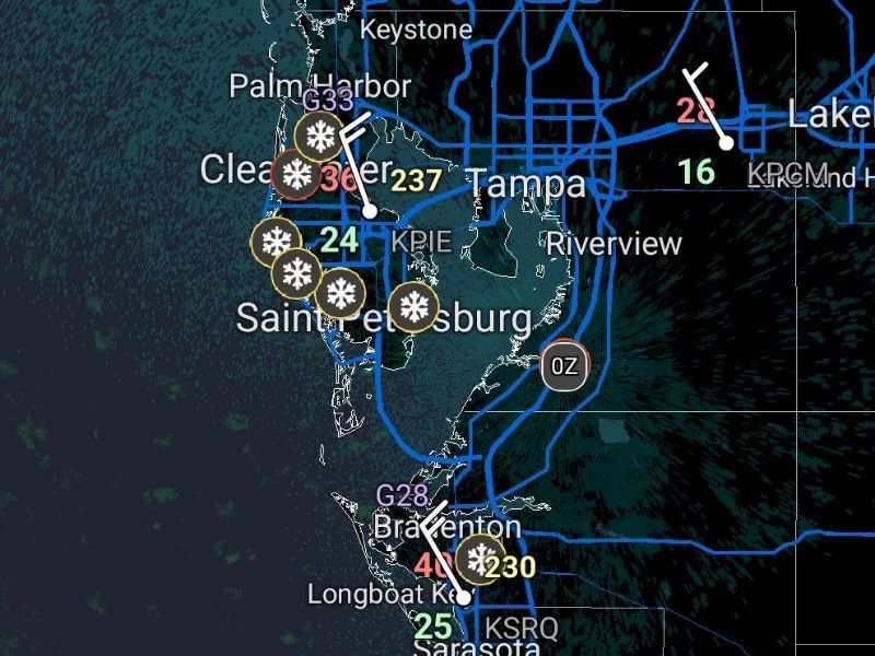
Radar and spotter-style observations show snowflake icons and wintry precipitation signals clustered near Clearwater, Palm Harbor, St. Petersburg, and Tampa, with additional indications farther south toward Bradenton and Sarasota. These reports align with very cold surface temperatures, generally in the mid-30s or colder, allowing frozen precipitation to briefly survive to the ground.
While amounts are negligible, the presence of flakes alone is highly unusual for Florida, especially at sea level.
Temperatures and Wind Supporting Brief Flurries
Observed temperatures in the region early this morning ranged from the low-to-mid 30s, with strong northwest winds continuing behind the cold front. Those winds helped pull shallow cold air and moisture together just long enough to generate light flurries or ice crystals, particularly closer to the Gulf Coast.
Wind chills were significantly colder than air temperatures, reinforcing how anomalous this setup is for the peninsula.
No Accumulation Expected, but Meteorologically Notable
There is no indication of accumulation, and impacts to roads or travel are not expected. However, from a meteorological standpoint, snowflakes being observed in coastal West-Central Florida is exceptionally rare, especially outside of historic cold outbreaks.
These events often last only minutes to an hour and can vary greatly even within a few miles.
Radar Signatures Show Patchy, Shallow Precipitation
Radar imagery indicates light, patchy returns offshore and along the coast, consistent with flurries rather than organized snowfall. This supports the idea that very shallow moisture is interacting with unusually cold air, producing flakes that quickly dissipate as conditions shift.
Such setups are notoriously difficult to forecast precisely and often rely on real-time observation.
Why This Event Is Getting Attention
Many long-time Florida residents report never seeing snowflakes in their lifetime, particularly in areas like Tampa Bay. Even brief flurries during a cold outbreak place this event among the more remarkable Florida winter weather moments in recent decades.
This aligns with earlier model guidance that hinted at the possibility of flakes reaching unusually far south .
If you’re in West-Central Florida and observed snowflakes, sleet, or ice crystals this morning, share what you saw and where. Local observations help document rare events like this. Stay with CabarrusWeekly.com for continued updates and in-depth coverage of this historic cold outbreak.