Southern Connecticut and Long Island Face Overnight Snow Showers With Dusting to Light Coating Expected Saturday Morning
NEW YORK, NEW YORK — A late-season wintry surprise is on the way for parts of the Northeast. Isolated to scattered snow showers are possible overnight tonight into Saturday morning, March 28, 2026, with the heaviest activity focused across southern Connecticut and Long Island.
The forecast was issued by the National Weather Service New York City office on March 27, 2026 at 7:19 PM EDT.
What to Expect and When
The timing of this system is overnight — meaning most residents will wake up to the results rather than watch it happen.
Friday Night, March 27 — overnight — Snow showers develop across southern Connecticut and Long Island. Precipitation probability ranges from 29% to 44% across the most impacted areas. The highest chances sit across coastal Connecticut and central Long Island.
Saturday Morning, March 28 — early hours — A dusting to light coating of snow is possible when residents wake up. Accumulations are expected to remain under 1 inch across most of the region. Snow showers taper off through the morning as the system exits.
Forecast Confidence Level
High confidence that snow showers will develop overnight across southern Connecticut and Long Island.
Medium confidence on exact accumulation amounts — totals will depend on the timing and intensity of individual snow shower bands. Most areas will see a dusting, though localized spots could briefly see a light coating.
Precipitation Probability by City
Here is the 12-hour precipitation probability valid Friday night 8:00 PM through Saturday 8:00 AM EDT:
| City | Precipitation Probability |
|---|---|
| New Haven | 44% |
| Bridgeport | 44% |
| Islip | 44% |
| Syosset | 30% |
| Riverhead | 30% |
| East Haddam | 30% |
| New London | 30% |
| Norwich | 30% |
| Montauk | 29% |
| Stony Brook | 30% |
| Westhampton | 29% |
| NYC / JFK | 24–25% |
| Newark | 24% |
| Danbury | 14% |
| Freehold | 14% |
| Hartford | 11% |
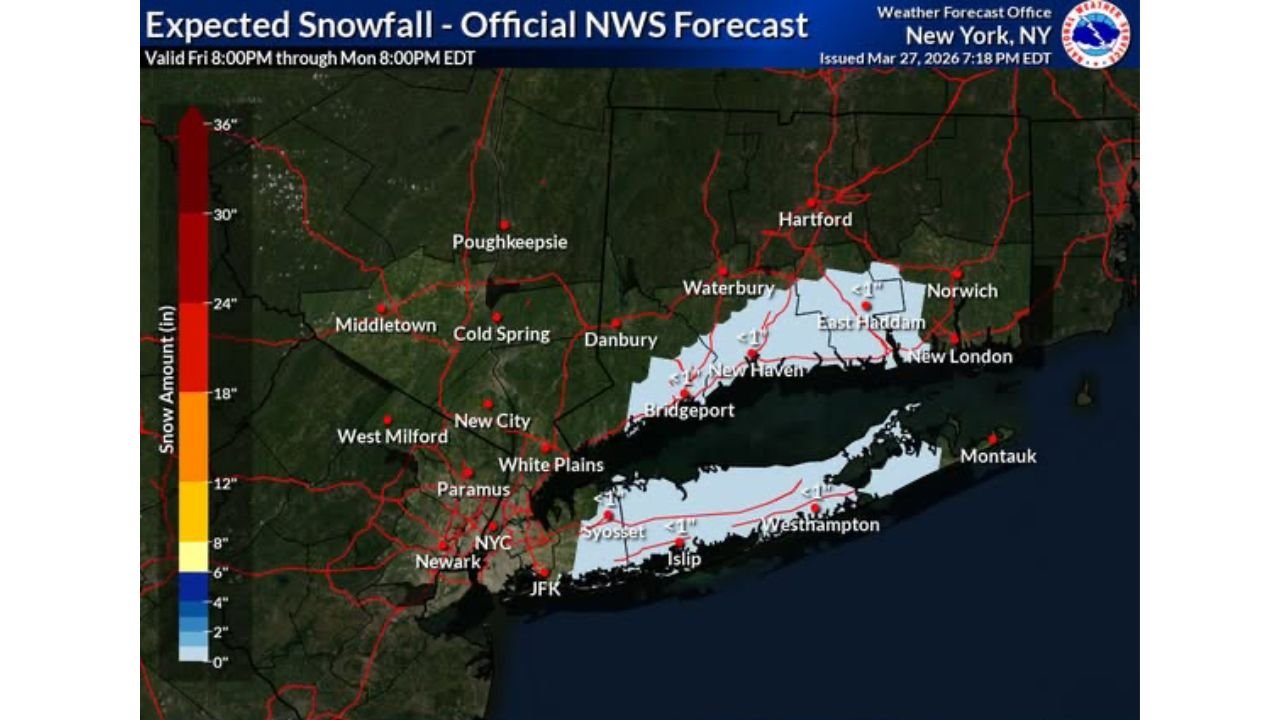
Expected Snowfall Totals
Official NWS snowfall forecast valid Friday 8:00 PM through Monday 8:00 PM EDT:
| Area | Expected Snowfall |
|---|---|
| Southern Connecticut (New Haven, Bridgeport, East Haddam, New London) | Under 1″ |
| Long Island (Islip, Syosset, Westhampton) | Under 1″ |
| NYC / JFK / Newark | Dusting possible |
| Danbury / White Plains | Minimal to none |
| Hartford / Waterbury / Norwich | Minimal |
| Poughkeepsie / Middletown | Little to no accumulation expected |
What to Wear and How to Prepare
Bundle up Saturday morning — temperatures will be cold enough to support snow overnight, so dress in warm layers before heading out.
Check your windshield before driving — a light coating of snow or frost on vehicles is possible across Long Island and southern Connecticut by early Saturday.
Allow extra time on the roads — even a dusting can create slick conditions, especially on bridges, overpasses, and untreated surfaces overnight and into early morning.
Residents further inland toward Poughkeepsie, Middletown, and Paramus can expect little to no accumulation from this event.
The Bottom Line
This is a minor late-season snow event, not a significant storm. Southern Connecticut and Long Island residents should expect a dusting to light coating when they wake up Saturday morning, with conditions improving as the day progresses. No major travel disruptions are anticipated, but roads may be slick in the early morning hours.
For the latest updates, monitor weather.gov/nyc through the overnight hours.
Bookmark cabarrusweekly.com and turn on notifications so you never miss a weather update, storm alert, or forecast change across the United States — delivered daily, before the weather hits.