Southern Illinois Supercell Near Sainte Marie and Olney Shows Strong ZDR Arc and Clear Inflow, Raising Short-Term Tornado Concern
ILLINOIS — A highly organized supercell is tracking across southern Illinois this evening, with radar signatures near Sainte Marie and Olney indicating a storm structure capable of producing severe weather, including large hail and possible tornadic development.
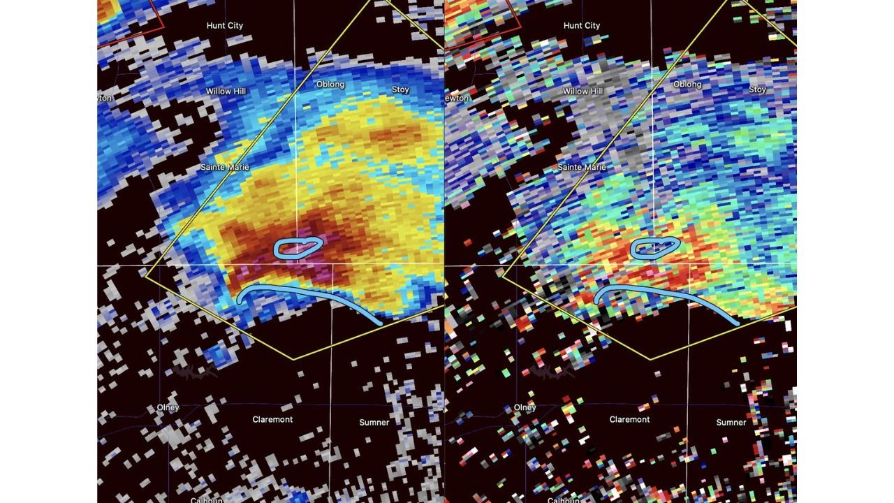
Radar Reflectivity Shows Intense Core Near Sainte Marie
Base reflectivity imagery highlights a concentrated core of heavy precipitation just south and east of Sainte Marie, extending toward Claremont and Sumner. The deep red and maroon shading within the storm indicates a powerful updraft capable of sustaining large hail.
The warning polygon surrounding the storm includes communities near Willow Hill, Oblong, and Hunt City, suggesting meteorologists are closely monitoring its evolution. The reflectivity structure shows a classic supercell shape, with a dominant core and organized precipitation wrapping around the circulation area.
Well-Defined ZDR Arc Signals Strong Updraft Structure
Dual-polarization radar imagery reveals a pronounced ZDR arc on the inflow side of the storm. This signature, often associated with strong and sustained updrafts, indicates large raindrops being sorted within the storm’s inflow region.
The ZDR arc appears along the southern flank of the supercell, where clean inflow is feeding warm, moist air into the storm. This inflow is critical for maintaining rotation and strengthening the storm’s mesocyclone.
When a ZDR arc becomes well defined and persistent, it often signals that a storm is structurally healthy and capable of producing severe hazards in the near term.
Hail Fallout Zone Developing Downstream
Downwind of the strongest updraft, radar indicates a developing hail fallout zone, where large hail may be reaching the surface. This region lies east of the core, closer to Claremont and Sumner, as precipitation spreads outward from the rotating center.
Large hail potential is elevated given the strength of the reflectivity core and the organized storm structure. Residents within the warning area should prepare for the possibility of damaging hailstones.
Clear Inflow Enhances Short-Term Tornado Potential
Perhaps most concerning is the storm’s access to clear, uninterrupted inflow, particularly from areas south of Sainte Marie. Unlike storms embedded within clusters, this supercell appears relatively isolated, allowing it to draw in undisturbed air.
This setup increases the likelihood that the storm could intensify over the next hour. With a strong updraft, organized rotation, and favorable inflow, this cell may be the best-positioned storm in the region for tornadic development in the short term.
Communities in Path Should Stay Alert
Residents in and around Sainte Marie, Olney, Willow Hill, Oblong, Hunt City, Claremont, and Sumner should closely monitor local warnings. Supercells with this structure can evolve quickly, and conditions may change within minutes.
Strong winds, large hail, and isolated tornado development remain possible as the storm continues moving across southern Illinois.
If severe weather is impacting your area, share your reports safely at CabarrusWeekly.com to help keep others informed.