Southern States Warm Up While Northern Plains Stay Cool as Early April Temperature Pattern Splits United States
UNITED STATES — A clear divide is emerging in the early April temperature pattern, with warmer-than-average conditions spreading across the southern U.S. while cooler air lingers across the northern tier, creating a split setup nationwide.
Southern Tier Sees Warmer Than Average Start to April
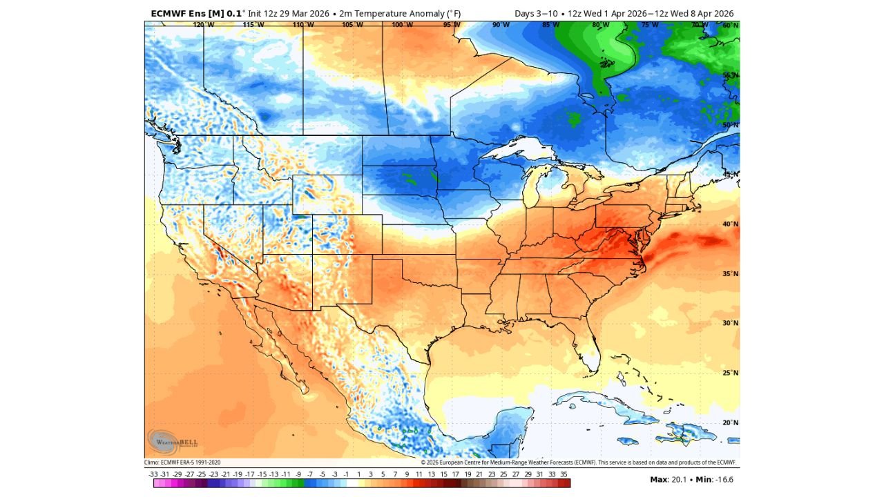
Forecast data for the first week of April shows a broad area of above-average temperatures stretching from Texas through the Southeast and into parts of the Mid-Atlantic.
States including Texas, Louisiana, Mississippi, Alabama, Georgia, and the Carolinas are expected to experience temperatures running several degrees above normal.
This warming trend may also extend into parts of the Mid-Atlantic, including Virginia and North Carolina, where early spring warmth begins to build more consistently.
Northern Plains and Upper Midwest Stay Cooler
In contrast, a large portion of the Northern Plains and Upper Midwest, including states like North Dakota, South Dakota, Minnesota, and parts of Wisconsin, are expected to remain cooler than average.
This cooler pattern is driven by persistent troughing and cooler air masses settling over the northern tier of the country.
As a result, temperatures in these regions could run below seasonal norms, especially during the early part of April.
Northeast Begins Gradual Warm-Up Trend
After a colder and more variable pattern through late March, the Northeast is expected to begin a gradual warming trend during the first week of April.
While not as warm as the southern states, areas including New York, Pennsylvania, and parts of New England may see temperatures slowly move closer to or slightly above average.
This marks a shift toward more typical spring conditions after recent fluctuations.
Clear Temperature Contrast Across the Country
The overall pattern highlights a strong contrast between regions, with a pronounced north-to-south temperature gradient setting up across the United States.
Warm anomalies dominate the southern half of the country, while cooler anomalies remain locked across the north.
This type of split pattern is common during spring transition periods, when competing air masses battle for dominance across the country.
What This Pattern Means Going Forward
This early April setup suggests continued variability, with the potential for active weather along the boundary between warm and cool air masses.
Such contrasts often lead to increased storm activity in the central U.S., while the southern states continue to trend warmer.
Residents across the country should expect region-specific conditions, with warmth building in the South, cooler air lingering in the North, and gradual moderation in the Northeast.
Stay with CabarrusWeekly.com for continued updates, and share how this early April temperature pattern is affecting your area.