SPC 11:48 AM CDT Update: Moderate Risk Locked In for Illinois and Indiana as Severe Weather Threat Peaks Across Midwest
UNITED STATES — The Storm Prediction Center (SPC) issued its 11:48 AM CDT Public Severe Weather Outlook (PWO) highlighting an elevated and potentially dangerous severe weather setup across parts of the Midwest, particularly Illinois and Indiana.
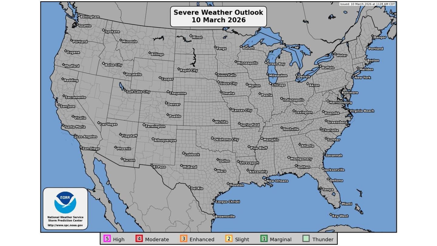
The Severe Weather Outlook for March 10, 2026, maintains a Level 4 out of 5 Moderate risk across portions of Illinois and Indiana, signaling increasing confidence in impactful severe storms later today.
Moderate Risk Focused on Illinois and Indiana
The Moderate risk zone is centered over:
- Central and northern Illinois
- Central and northwest Indiana
- Areas near and between Chicago and Indianapolis
Communities including Chicago, Peoria, Springfield, Joliet, and Indianapolis lie within or near the higher-end severe corridor.
A Moderate risk designation is not routine. It is reserved for days when forecasters expect a concentrated area of significant severe weather, including tornadoes, damaging winds, and large hail.
Broader Severe Corridor Extends Southwest
The outlook also shows a broader severe weather swath extending southwest through:
- Missouri
- Eastern Kansas
- Eastern Oklahoma
- Arkansas
These regions fall under lower categories such as Enhanced and Slight risk, indicating scattered severe storms are possible. However, the greatest concern for stronger, more numerous tornadoes remains focused in Illinois and Indiana.
Tornado Threat Remains Primary Concern
While the SPC outlook includes all severe hazards, earlier tornado probability guidance and public messaging emphasize tornado potential as the leading risk in the Moderate zone.
Conditions across Illinois and Indiana are supportive of:
- Rotating supercells
- Multiple tornadoes
- A few potentially strong tornadoes
The combination of instability and wind shear across the Midwest places the Illinois–Indiana corridor in a favorable environment for organized storm development this afternoon and evening.
Timing: Afternoon Into Tonight
Storms are expected to intensify through the afternoon and continue into the evening hours. This raises additional concern for after-dark severe weather, when tornado visibility becomes limited.
Residents across:
- Chicago metro
- Central Illinois
- Indianapolis metro
- Northwest Indiana
should closely monitor weather updates throughout the day.
Why the 11:48 AM Update Matters
The midday PWO serves as a public-facing alert emphasizing the seriousness of the setup. When the SPC issues a Public Severe Weather Outlook alongside a Moderate risk, it signals elevated confidence in potentially significant impacts.
This is not a marginal or routine thunderstorm day. The atmosphere across the Midwest is primed for organized severe storms capable of producing damaging weather.
Bottom Line
The SPC’s 11:48 AM CDT update keeps Illinois and Indiana under a Moderate severe weather risk, with tornadoes, large hail, and damaging winds possible later today. The highest concern remains across central and northern Illinois into Indiana, including major population centers.
Residents in the highlighted corridor should remain weather aware, review safety plans, and be prepared to act quickly if warnings are issued.
CabarrusWeekly.com will continue to track updates as this severe weather threat evolves.