SPC Day 4 Outlook Highlights 15% Severe Risk Tuesday April 14 From Texas Through Midwest As ECMWF Shows Explosive CAPE And Large To Very Large Hail Expected As Primary Threat With Tornado Potential Still Uncertain
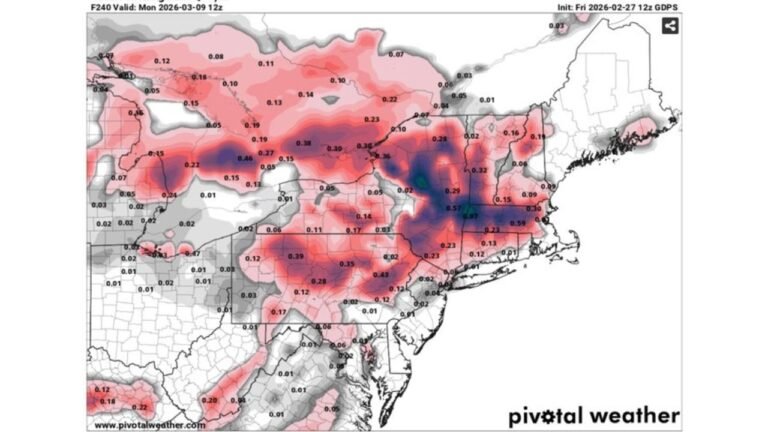
UNITED STATES — The NOAA Storm Prediction Center has issued its Day 4 Severe Weather Outlook for Tuesday, April 14, 2026, valid from Tuesday April 14 at 1200Z through Wednesday April 15 at 1200Z, highlighting a 15% severe weather probability corridor stretching from Texas northward through the heart of the Midwest. Meanwhile, forecast model data is raising significant concern about large to very large hail being the headline threat of the day.
SPC Day 4 Outlook: What The Maps Show
The SPC outlook issued at 0844Z on April 11, 2026 by forecaster Leitman depicts:
- A 15% severe weather probability zone covering a large north-to-south corridor from Texas through Oklahoma, Kansas, Missouri, Iowa, and Illinois — extending into the Great Lakes region
- A 30% severe weather probability area embedded within the broader risk zone, focused across the central corridor where the greatest concentration of severe weather ingredients will overlap Tuesday afternoon and evening
- The overall risk footprint is large, covering millions of people across the central United States
Forecaster Confidence: Large Hail Is The Primary Concern Tuesday
One of the most notable aspects of Tuesday’s setup is what an experienced forecaster is flagging as the headline threat. Despite the broad severe weather risk, the tornado threat is being characterized as still uncertain and iffy, while confidence in a significant large hail threat is described as pretty high.
Hodographs and general atmospheric profiles across multiple forecast models consistently support large to very large hail with any storm that gets going Tuesday — meaning hailstone sizes could be significant and potentially damaging across a wide area of the risk zone.
The forecaster also expressed mild surprise that a 30% corridor was not added for the Midwest on Day 4, suggesting the severe weather potential across that region may be even higher than what the current outlook formally depicts — a signal that upgrades are likely as Tuesday gets closer.
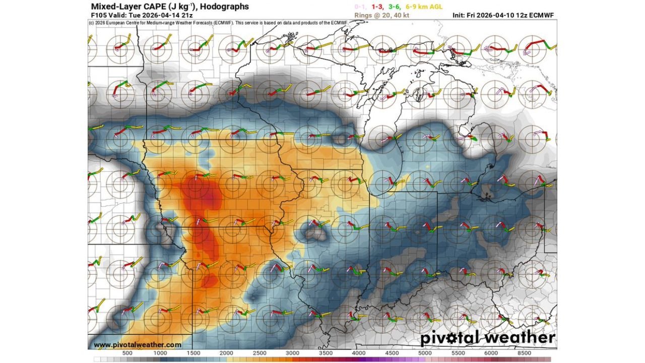
ECMWF Model Data: Explosive Instability In Place Tuesday
The European Centre for Medium-Range Weather Forecasts model — one of the most respected global forecast models — paints a vivid picture of the atmospheric instability in place for Tuesday, April 14 at 21Z.
The Mixed-Layer CAPE (Convective Available Potential Energy) analysis shows:
- Extreme instability values — depicted in deep red and orange colors — concentrated across Oklahoma, Kansas, and into Missouri and Iowa, indicating several thousand joules per kilogram of energy available to fuel severe thunderstorm updrafts
- CAPE values exceeding 3,000 to potentially 4,000+ J/kg across the most unstable portions of the warm sector — more than sufficient to support violent thunderstorms capable of very large hail
- Hodographs across the region show favorable wind shear profiles that support organized, long-lived supercell thunderstorms — the storm type most capable of producing large and very large hail alongside tornado potential
This level of instability combined with the wind shear profiles makes Tuesday’s severe weather threat a high-end hail event at minimum, with the potential for additional hazards depending on how storm mode evolves.
Primary Hazards Tuesday April 14
Based on the SPC outlook and ECMWF model data, here is the ranked threat breakdown for Tuesday:
- Large to Very Large Hail — PRIMARY and HIGH CONFIDENCE threat — hodographs and CAPE profiles across multiple models strongly support significant hail with any storm that develops
- Damaging Winds — significant threat especially as storms evolve from discrete supercells into clusters or squall lines later in the day
- Tornadoes — possible but uncertain — the tornado threat exists within this setup but forecasters note it remains the least certain of the three hazards at this stage
Who Is In The Risk Zone Tuesday
The Day 4 SPC outlook risk corridor covers a broad stretch of the central United States. Cities and regions within the severe weather probability zone include areas across:
- Texas and Oklahoma in the southern portion of the risk zone
- Kansas and Missouri through the central corridor
- Iowa and Illinois across the northern and eastern portions
- Great Lakes region at the northern edge of the outlook area
Expect Upgrades As Tuesday Approaches
With forecaster confidence already high for large hail and model data showing explosive instability, residents across the Plains and Midwest should anticipate that Tuesday’s severe weather outlook will likely be upgraded in the coming days as the event comes into sharper focus.
Stay with CabarrusWeekly.com for continuing and updated coverage of Tuesday’s significant severe weather threat across the central United States as this dangerous setup continues to develop.