Storm Track Flip Expected Around March 5 as Heavy Rain Signals Expand from Texas to the Midwest and Ohio Valley
UNITED STATES — Long-range guidance is signaling a notable pattern change in early March, with an active storm track expected to develop from the Southern Plains into the Midwest beginning around March 5 and potentially lasting into mid-month.
Rapid Transition Toward an Active Pattern
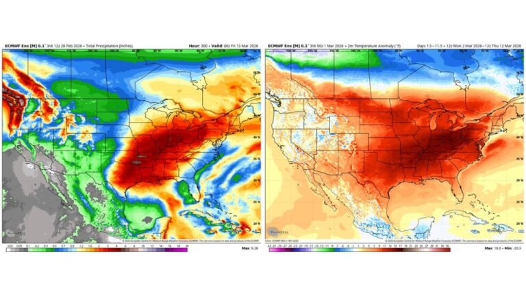
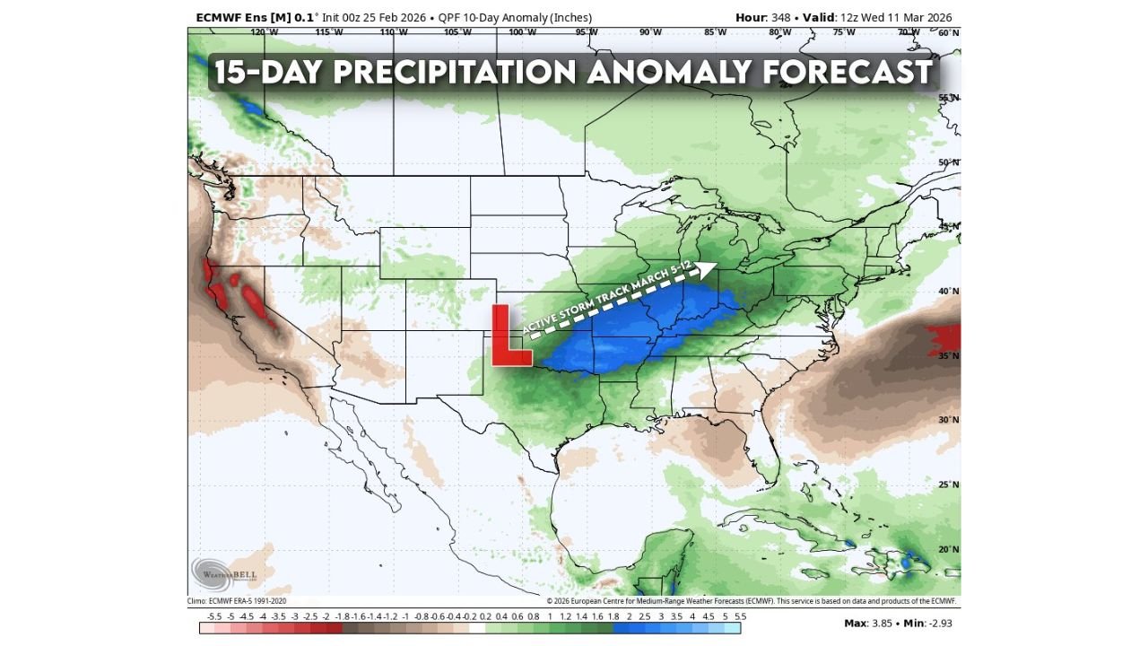
Ensemble precipitation anomaly forecasts highlight a corridor of above-normal rainfall stretching from north Texas and Oklahoma through Arkansas, Missouri, Illinois, Indiana, and into the Ohio Valley.
This shift represents a clear departure from quieter late-February conditions, as a developing low-pressure system over the Southern Plains begins to anchor a more consistent storm track.
The projected axis of activity runs southwest to northeast, suggesting repeated systems may track along a similar path between March 5 and March 12.
Heaviest Anomalies Focused Central U.S.
Forecast anomalies show the most significant precipitation departures centered across:
Eastern Texas
Arkansas
Missouri
Illinois and Indiana
Kentucky and portions of Ohio
These areas are depicted with the strongest positive precipitation signals, indicating totals could run well above average over the 10- to 15-day period.
Meanwhile, parts of the Southeast and Florida appear comparatively drier, and sections of the Southwest and California show mixed signals with localized deficits and surpluses.
Potential Impacts Still Uncertain
While confidence is increasing in a wetter pattern across the central United States, specific impacts remain too early to determine.
An extended active storm track could raise the possibility of:
Heavy rainfall episodes
Localized flooding concerns
Increased severe thunderstorm potential
However, the magnitude and placement of these risks will depend on the strength and timing of individual storm systems as the pattern evolves.
Drought Relief Possible in Some Areas
For regions experiencing dry conditions across parts of the Southern Plains and Mid-Mississippi Valley, the anticipated storm track could provide meaningful rainfall.
Repeated systems tracking from Texas into the Midwest often bring sustained precipitation over multiple days, increasing the likelihood of measurable rainfall totals.
Still, whether this translates to long-term drought improvement will depend on rainfall distribution and soil absorption rates.
Monitoring the Early March Pattern Shift
The transition appears likely to begin around March 5, with guidance suggesting the pattern may persist into mid-month and possibly beyond.
Residents across Texas, Arkansas, Missouri, Illinois, Indiana, and the Ohio Valley should monitor updates as forecast details become clearer in the coming days.
If you live in the projected storm corridor, keep us informed about rainfall totals and changing conditions in your area. Stay updated on this evolving pattern at CabarrusWeekly.com.