Strong Cold Front Brings Powerful Northwest Wind Gusts to Florida, Dropping Wind Chills Into Single Digits by Sunday Morning
FLORIDA — A strong cold front sweeping through Florida this weekend is expected to deliver powerful northwest winds, creating blustery conditions Saturday and driving wind chills into the single digits overnight into Sunday morning, especially across exposed areas.
Gusty Northwest Winds Expected Statewide Saturday
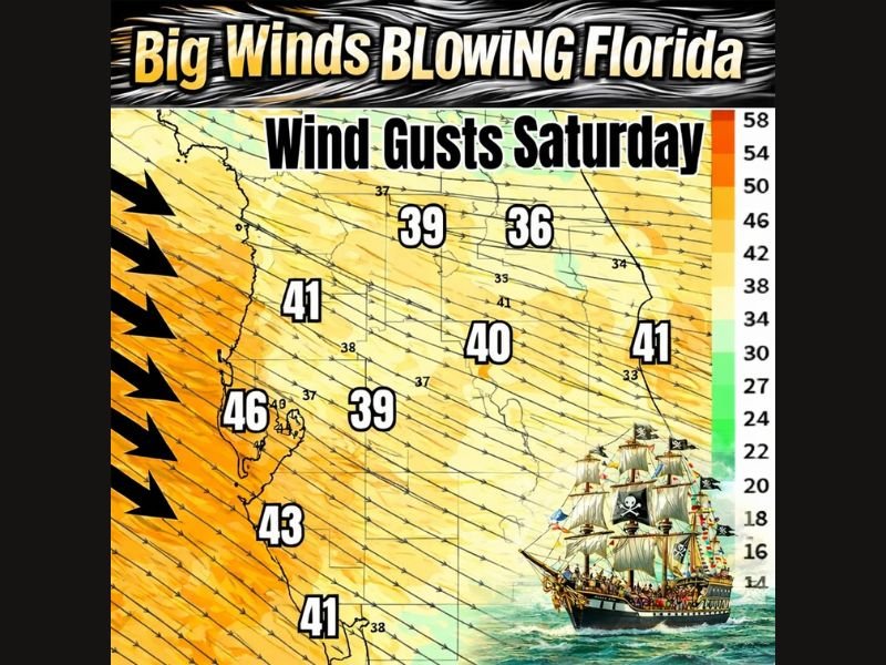
Forecast guidance shows widespread strong wind gusts across much of Florida on Saturday, as cold air surges in behind the advancing front. Wind gusts are expected to range from 35 to 45 mph across interior and coastal areas, with the strongest gusts focused along the Gulf Coast and west-central Florida.
Model data highlights gusts near 40 mph around Tampa Bay, upper 30s to low 40s across central Florida, and gusts exceeding 45 mph along parts of the west coast, where onshore and offshore wind interactions will be strongest.
Coastal Areas and Events Will Feel the Impact Most
The timing of the strongest winds coincides with Saturday evening, meaning outdoor activities—especially along the coast—will feel the full force of the front. Gusty northwest winds will create rough marine conditions, elevated wave heights, and difficult conditions for boating.
Areas near the Tampa Bay region, including coastal communities, should prepare for sustained strong winds and frequent gusts, particularly after sunset.
Wind Chills Plunge Overnight Into Sunday Morning
As winds remain elevated overnight, temperatures dropping into the 30s and lower 40s will combine with gusty conditions to produce wind chills falling into the single digits in parts of the state. Even locations accustomed to mild winters will feel a sharp, uncomfortable cold by early Sunday morning.
This level of wind chill is highly unusual for Florida and may pose risks to those spending extended time outdoors overnight.
Why Florida Wind Events Can Be So Intense
Strong cold fronts in Florida often bring outsized wind impacts because of the sharp temperature contrast between incoming cold air and the warm Gulf waters. That contrast accelerates wind speeds, especially when the front moves in from the northwest, aligning with the peninsula’s geography.
This setup favors fast-moving, gusty winds, even in the absence of severe thunderstorms.
What Residents Should Prepare For
Loose outdoor items should be secured ahead of Saturday, and residents should use caution when driving high-profile vehicles during peak wind periods. Coastal and marine interests should be prepared for hazardous conditions, and anyone attending outdoor events should dress for much colder, wind-driven conditions than typical Florida winters.
If you experience strong winds, falling temperatures, or unusually harsh wind chills this weekend, share what you’re seeing. Stay informed with continued weather updates and analysis at CabarrusWeekly.com.