Strong Cold Front Signals Mid-March Cooldown for the Northeast Around March 12–14 as Ensemble Models Show Sharp Temperature Drop
UNITED STATES — After a stretch of above-normal warmth across the East, ensemble guidance now points to a strong cold front arriving around March 12–14, bringing a noticeable cooldown to the Northeast and Mid-Atlantic.
Ensemble Consensus Shows Sharp Contrast Developing
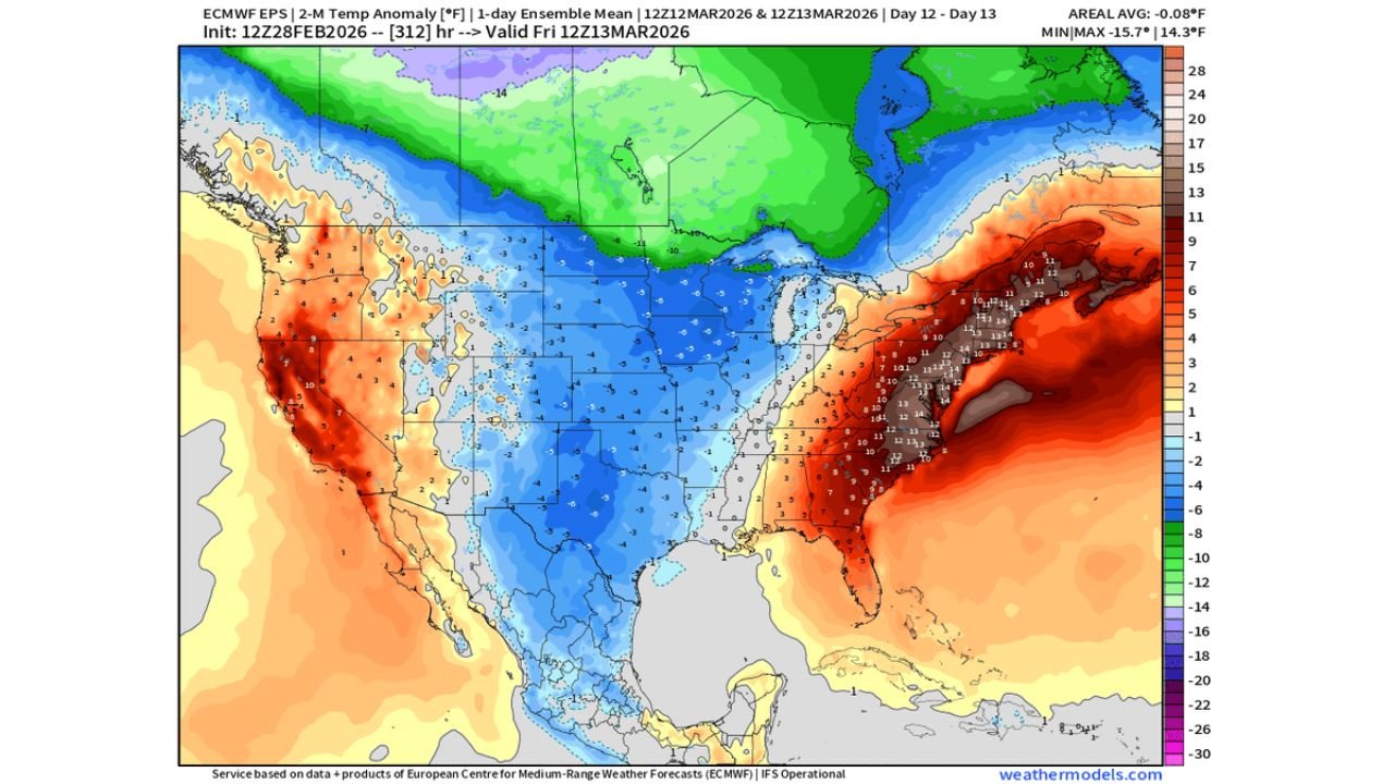
EPS ensemble temperature anomaly data valid for March 12–13 highlights a pronounced temperature gradient across the country. While the East Coast remains well above normal ahead of the front, cooler air is projected to surge eastward from the central United States.
The anomaly map shows:
Below-normal temperatures expanding across the Plains and Midwest
A tightening boundary between warm East Coast air and incoming cooler air
Strong positive anomalies offshore of the East Coast just prior to frontal passage
This setup supports a sharp transition once the front clears the region.
Northeast Warmth Ends as Front Pushes Offshore
Ahead of the front, the Northeast continues to run significantly above seasonal averages. However, model consensus indicates the frontal boundary will sweep through the region between March 12 and March 14, ending the recent temperature relief.
Behind the front, temperatures are projected to fall back toward:
Near-normal readings for mid-March
Higher heating demand compared to the previous warm stretch
While this does not appear to be an extreme Arctic outbreak, it represents a meaningful correction from the unseasonably warm conditions currently in place.
Temperature Trends Suggest Brief Cooldown
Ensemble trend guidance shows a noticeable dip around the March 12–14 window, followed by stabilization near climatological averages.
This indicates:
A temporary interruption of the warm pattern
Cooling sufficient to bring Heating Degree Days closer to normal
Potential rebound toward warmer conditions later in the month
The data does not yet suggest a prolonged cold regime but instead supports a transitional cooldown.
Broader National Pattern
While the East cools, parts of the West continue to show warmer-than-normal conditions, reinforcing a broader split-flow pattern across North America.
The key takeaway is the eastward progression of cooler air from the central U.S. into the Northeast during the mid-March timeframe.
What to Watch Moving Forward
Residents across the Northeast should prepare for:
A noticeable temperature drop after March 12
A return to more seasonable mid-March conditions
Potential for brisk winds with frontal passage
We will continue monitoring ensemble trends to determine whether this cooldown remains brief or if additional cold intrusions follow later in March.
If you are in the Northeast and notice the sharp change in temperatures next week, share your local observations with us at CabarrusWeekly.com as we track this developing mid-March pattern shift.