Strong Cold Front to Send Temperatures Tumbling Across North Carolina and the Southeast Next Week, Freeze Risk Reaches Gulf Coast
NORTH CAROLINA — After a stretch of unseasonably mild weather, a powerful cold front is poised to sweep across the Southeast early next week, sending temperatures sharply lower and bringing freeze potential as far south as the northern Gulf Coast.
Winter-Like Air Mass Surges South Across the Southeast
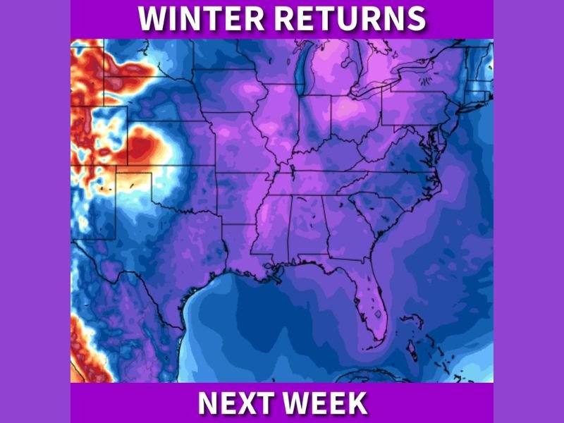
Forecast guidance shows a widespread push of colder air diving southward across North Carolina, South Carolina, Georgia, Alabama, Mississippi, Tennessee, and Florida. The temperature anomaly map highlights a broad region of below-normal readings covering nearly the entire Southeast and stretching into the Ohio Valley.
This incoming air mass will erase the recent “fake spring” feel and replace it with winter-like conditions for early next week, especially during the overnight and early morning hours.
Freeze Potential Reaches the Northern Gulf Coast
One of the most notable aspects of this setup is the freeze potential extending all the way to the northern Gulf Coast on Monday and Tuesday mornings. That includes portions of southern Alabama, southern Mississippi, and the Florida Panhandle, where temperatures could dip to or below freezing.
Such cold snaps can have agricultural impacts and may threaten early-blooming vegetation if protective measures are not taken. Residents in typically milder Gulf Coast communities should prepare for unusually cold mornings.
40s Penetrate Deep Into South Florida
Even areas far removed from typical freeze risk will feel the chill. Forecast projections indicate 40-degree temperatures penetrating deep into South Florida, including areas that often remain mild during winter fronts.
While a hard freeze is not expected that far south, the cooler air mass will still represent a significant departure from normal temperatures for this time of year. Coastal breezes and clear overnight skies could enhance the cooling effect in some inland locations.
Coldest Mornings Expected Monday and Tuesday
The most pronounced temperature drops are expected Monday morning and again Tuesday morning, when the coldest air settles across the region. Light winds and clear skies behind the front may allow temperatures to fall efficiently overnight.
Residents across North Carolina and the broader Southeast should monitor updated forecasts as the front approaches. Wintertime systems can intensify quickly within 24 hours, and slight changes in timing or cloud cover can influence how low temperatures ultimately fall.
While this does not appear to be an extreme Arctic outbreak, it will be a notable and widespread return to winter conditions across the Southeast.
As colder air returns next week, let us know what temperatures you’re seeing in your community. Share your updates and stay weather-aware with ongoing coverage at CabarrusWeekly.com.