Strong El Niño Signal Emerging for Summer 2026 as IRI Multi-Model Data Shows Warming Pacific Trends
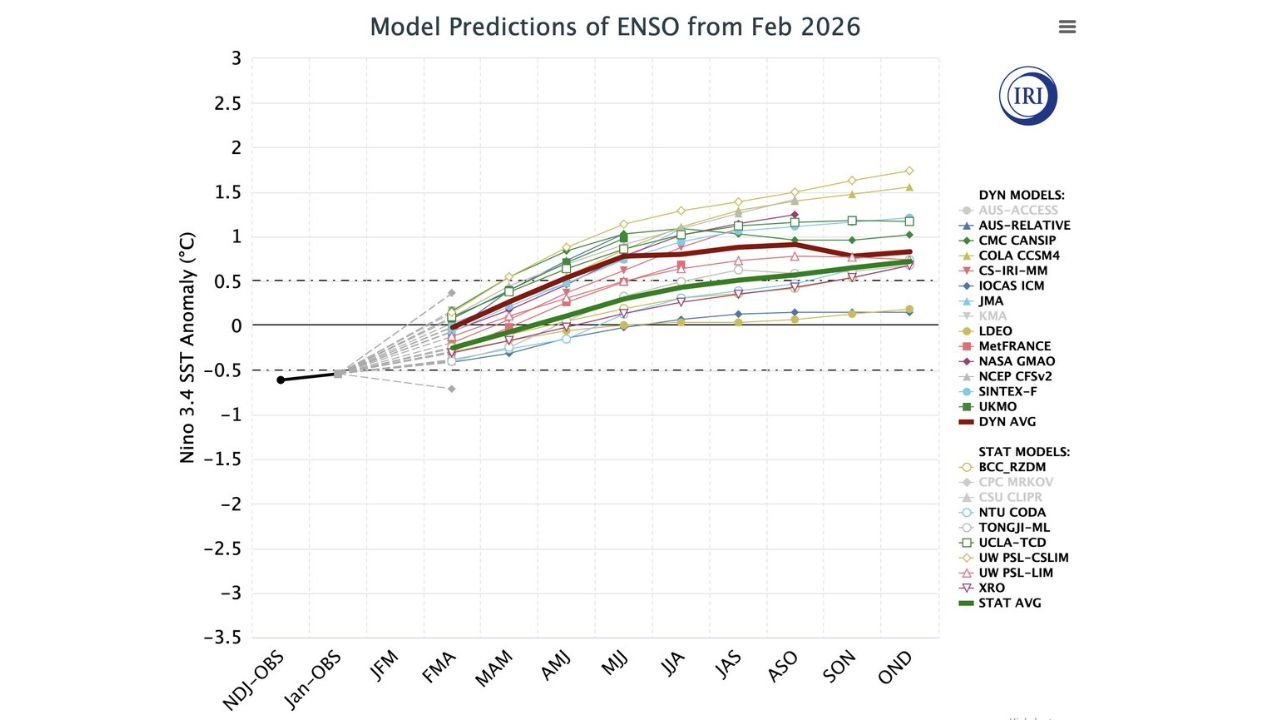
UNITED STATES — The latest February update from the International Research Institute (IRI) shows a growing and increasingly consistent signal for El Niño development into Summer 2026, with most major climate models projecting warming sea surface temperatures across the central Pacific.
Current Niño 3.4 observations remain slightly negative, but guidance trends strongly upward through spring and into summer.
Multi-Model Guidance Trends Positive by Late Spring
The February ensemble projections indicate a steady climb in Niño 3.4 sea surface temperature anomalies beginning in the March–April–May (MAM) period. By April through June (AMJ), most models move into positive territory, with many clustering between +0.5°C and +1.0°C.
By June–July–August (JJA) and continuing into early fall, several dynamic models project anomalies exceeding +1.0°C, which would meet moderate El Niño thresholds if sustained.
Importantly, both dynamic and statistical model averages trend upward, signaling broader agreement rather than isolated outliers.
Model Agreement Increasing Confidence
The chart shows improved alignment between major forecasting systems, including dynamic and statistical ensembles. When multiple independent modeling systems begin converging toward a similar solution, forecast confidence increases.
While there remains spread in exact intensity, the overall trajectory is upward through summer, supporting a developing warm-phase ENSO pattern.
What El Niño Could Mean for Summer Weather
A developing El Niño typically alters atmospheric circulation patterns across North America. During summer, it can sometimes help limit the most extreme and prolonged heat waves in parts of the United States, though impacts vary regionally.
However, El Niño does not guarantee a mild or wet summer everywhere. Certain regions of the Midwest can experience localized dry pockets, depending on how jet stream positioning evolves.
The strength and placement of Pacific warming will ultimately determine how atmospheric teleconnections respond.
Spring Transition Will Be Key
ENSO transitions often accelerate during spring, a period sometimes referred to as the “spring predictability barrier.” Continued warming through April and May would solidify the developing El Niño classification.
Should sea surface anomalies continue climbing toward or beyond +1.0°C by early summer, the United States could begin to see broader atmospheric responses by late summer and early fall.
Watching for Further Updates
Additional model updates in March and April will clarify intensity and persistence. While the signal is strengthening, final classification depends on sustained anomalies and ocean-atmosphere coupling.
For now, the February data strongly suggests the Pacific is shifting toward a warm phase heading into Summer 2026.
As we move closer to planting season and peak summer forecasting, continued monitoring will help refine regional impact expectations.
Stay updated on evolving climate signals and seasonal outlooks at CabarrusWeekly.com, and share your thoughts on what El Niño could mean for your area this year.