Strong Line of Storms Targets Louisiana, Mississippi and Alabama With Damaging Winds Main Threat Across the Deep South
ALABAMA — A strong line of thunderstorms is pushing across the Deep South today, with the primary concern centered on widespread damaging winds, while the overall tornado threat appears more limited.
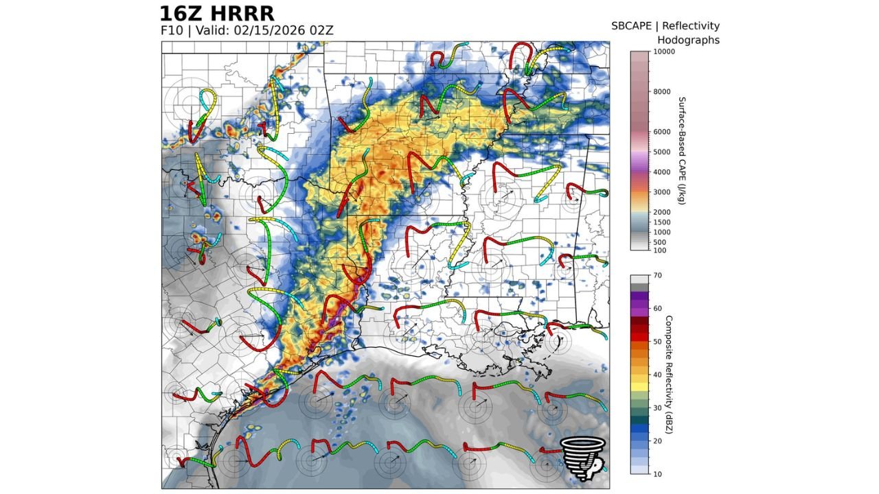
Forecast guidance shows a well-organized squall line stretching from the Gulf Coast northward into parts of Mississippi and western Alabama. This type of setup favors strong straight-line wind gusts along the leading edge of the storms.
Damaging Winds Expected to Be the Main Hazard
The most consistent threat with this system is damaging wind gusts, especially as the line advances eastward.
Storm structure and model guidance suggest momentum transfer from stronger winds aloft down to the surface. As a result, gusts capable of knocking down trees and causing scattered power outages are possible across:
South Louisiana, including coastal communities
Central and southern Mississippi
Western and southern Alabama
The most intense portion of the line appears along southern Mississippi into southeastern Louisiana near the Gulf Coast.
Tornado Threat Appears Limited but Not Zero
While wind damage remains the primary concern, a few embedded spin-ups cannot be ruled out within the line.
These brief circulations often develop quickly along kinks or bowing segments in the squall line. However, the broader setup does not currently favor long-lived or particularly strong tornadoes.
Still, residents should remain weather aware, as even short-lived tornadoes can produce localized damage.
Small Hail Possible, Especially Farther South
In addition to wind and isolated spin-ups, small hail may occur within stronger cells embedded in the line.
The risk for hail appears slightly higher farther south where instability values are stronger. While large destructive hail is not the main concern, pockets of small hail could accompany the most intense storms.
Storm Line Progression Through the Day
The storm line is expected to continue advancing eastward through Mississippi into Alabama, gradually weakening as it outruns the best instability.
Behind the line, conditions should begin to improve with drier air filtering in. However, until the system fully clears the region, residents across the Deep South should stay alert for rapidly changing weather conditions.
If strong winds or heavy storms impact your community, share your reports with us at CabarrusWeekly.com as we continue tracking this developing severe weather situation.