Strong Snow Signal Locks In for the Carolinas as Weekend Storm Track Decides How Far West Accumulations Spread
UNITED STATES — New ensemble guidance is sharpening confidence that accumulating snow is increasingly likely across the Carolinas this weekend, while the western edge of meaningful snowfall remains tightly dependent on the exact track of a developing coastal storm.
European Ensemble Data Shows a Strong Carolina Snow Signal
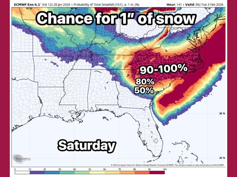
The latest ECMWF ensemble probability map, which averages all 51 European ensemble members, shows a high-confidence signal for at least 1 inch of snow across much of North Carolina and South Carolina. Probabilities peak in the 90–100 percent range across central and eastern North Carolina, with surrounding areas still holding 50–80 percent odds.
This type of ensemble agreement is notable, especially several days out, and suggests that accumulating snow is not a fringe outcome, but rather a likely scenario somewhere within the Carolinas.
Western Cutoff Remains the Biggest Question
While the snow signal itself is strong, how far west meaningful accumulation reaches remains unresolved. Current guidance places the Atlanta metro area very close to the western cutoff, meaning small shifts in storm track or timing could determine whether parts of northern Georgia see accumulating snow or only flurries.
This tight gradient is typical of Southeast winter storms, where cold air availability and storm positioning must align almost perfectly for snow to extend farther inland.
Track and Upper-Level Timing Will Decide Final Totals
Forecasters emphasize that the track of the surface low and the timing of upper-level energy will ultimately control where the heaviest snow bands set up. A slightly farther offshore track favors more snow inland, while a closer coastal path increases the risk of mixing or rain near the coast and sharpens the cutoff to the west.
Because of this sensitivity, snowfall totals may shift noticeably even within the final 24 to 36 hours before the storm arrives.
Snow Could Still Occur Outside the Highest Probability Zone
While the probability map highlights where accumulation is most likely, it does not rule out snow elsewhere. Light snow or flurries may occur outside the shaded zone, and some guidance has even hinted at flakes reaching unusually far south, potentially into parts of Florida, though accumulation there remains unlikely.
This distinction is important: the map represents likelihood of accumulation, not the absolute southern or western limit of snowflakes.
What This Means for the Carolinas Heading Into the Weekend
For residents across North Carolina and South Carolina, confidence is increasing that winter weather impacts are possible, with accumulating snow becoming more probable as guidance continues to converge. Travel impacts, timing, and exact totals will become clearer as the storm system takes shape.
Forecasters will continue refining the details as higher-resolution data becomes available.
If you’re in the Carolinas and watching this system closely, share what conditions look like where you are as the weekend approaches. Stay with CabarrusWeekly.com for continued updates, analysis, and local winter weather coverage.