Strong Storm Line Targets the Carolinas and Southeast This Afternoon as Gusty Winds and Isolated Tornado Risk Develop
NORTH CAROLINA — A cold front pushing into very warm, unstable air is expected to spark a line of strong to potentially severe storms across parts of the Southeast this afternoon, with the greatest impacts stretching from Georgia through the Carolinas and into coastal North Carolina.
Forecasters say the primary concern will be gusty, potentially damaging winds, though isolated tornadoes cannot be ruled out in stronger cells embedded within the line.
Line of Storms Extends From Georgia Through the Carolinas
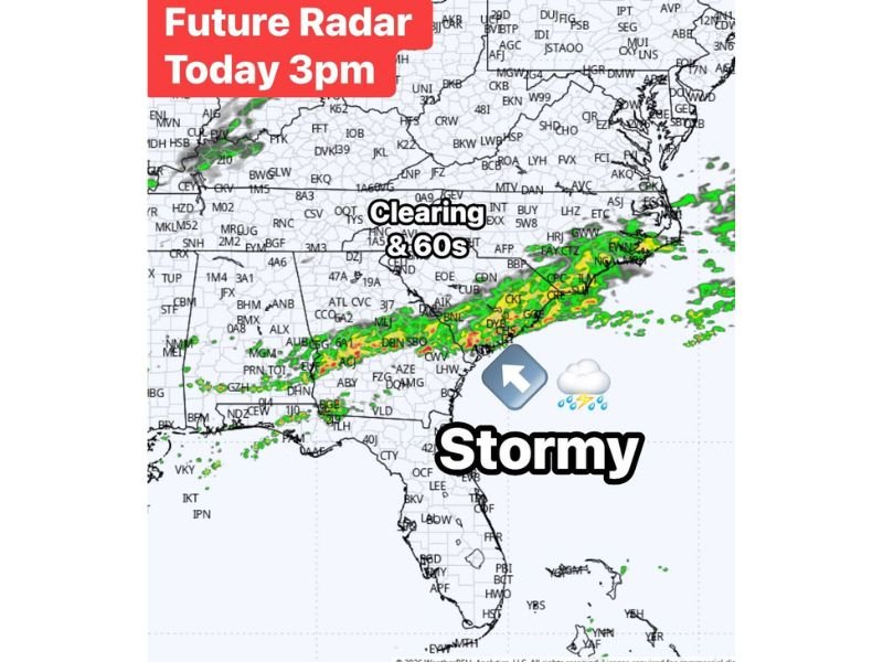
Future radar projections for around 3 PM show a well-defined band of thunderstorms stretching across:
- Southern and central Georgia
- South Carolina
- Eastern North Carolina
- Coastal sections of the Mid-Atlantic
The line marks the dividing boundary between cooler air advancing from the northwest and a warm, unstable air mass lingering to the south and east. That clash of air masses is where storms are expected to briefly intensify during peak afternoon heating.
Communities in eastern and coastal North Carolina appear particularly positioned for active weather during the mid-to-late afternoon window.
Main Threat: Gusty Winds, With Isolated Tornado Potential
The dominant hazard with this setup remains strong straight-line winds. As the squall line organizes, some storms may produce:
- Wind gusts capable of downing small trees or limbs
- Brief heavy rainfall reducing visibility
- Lightning and localized power outages
While the tornado threat is not widespread, forecasters note that isolated spin-ups are possible within stronger segments of the line, especially where wind shear enhances storm rotation.
Clearing Trend Behind the Front
Behind the storm line, conditions are expected to improve quickly. Radar projections show clearing skies pushing in from the west as cooler, drier air filters into the region.
Temperatures behind the front are forecast to settle into the 60s, bringing a noticeable change from the warm and unstable conditions that fueled the storms earlier in the day.
Timing and What to Expect
Storms are expected to move steadily eastward through the afternoon and early evening hours, with impacts diminishing as the line shifts offshore.
Residents across North Carolina and the broader Southeast should:
- Stay weather-aware during peak afternoon hours
- Monitor local alerts for any severe warnings
- Secure loose outdoor items in case of gusty winds
Updates will continue as the system evolves. For real-time storm tracking and Southeast weather updates, stay connected with CabarrusWeekly.com.