Strong Tornado and Baseball-Size Hail Threat Targets Central Illinois and Northwest Indiana as Warm Front Divides High-Risk Zone
UNITED STATES — A significant severe weather threat is unfolding today across Illinois and possibly northwest Indiana, where the position of a stalled warm front will determine whether communities face strong tornadoes or primarily destructive hail.
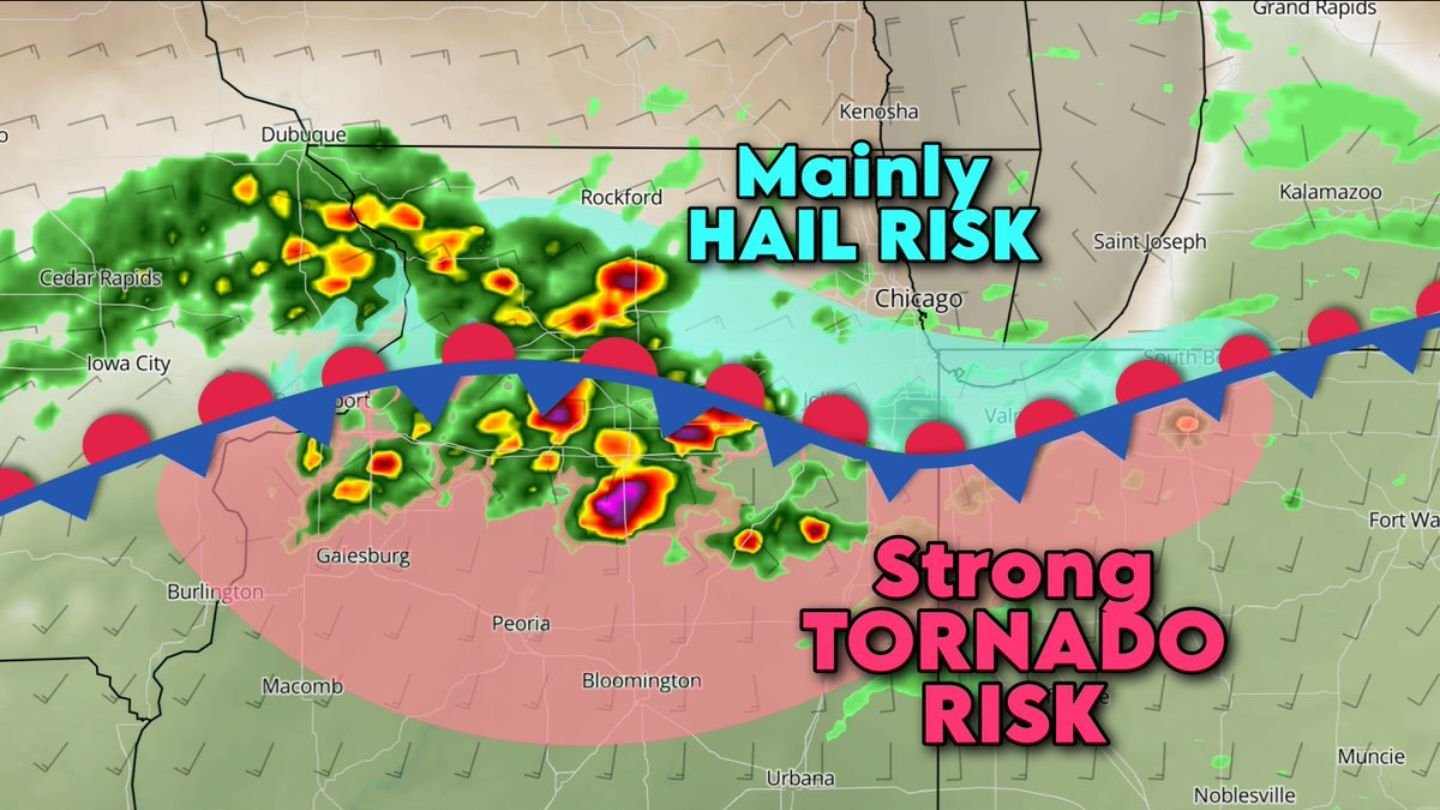
Forecasters say the setup is highly sensitive to the exact location of the stationary boundary stretching across central Illinois.
It All Comes Down to the Boundary
The stalled stationary/warm front divides two very different air masses:
- South of the boundary: warm, humid, unstable air
- North of the boundary: cooler, drier air
This sharp contrast is critical. Thunderstorms are expected to form on both sides of the boundary, but their behavior — and their hazards — will differ significantly.
Strong Tornado Risk South of the Front
Across central Illinois — including areas near:
- Peoria
- Bloomington
- Galesburg
- Macomb
- Urbana
— storms that remain on the warm side of the boundary could produce one or two strong tornadoes (EF2+).
In this zone, the atmosphere contains:
- Ample thunderstorm fuel (instability)
- Strong wind shear (changing winds with height)
- Favorable conditions for rotating supercells
If storms stay surface-based and rooted in the warm, moist air, the tornado threat increases substantially.
Large hail up to baseball size is also possible in the strongest storms south of the boundary.
Northwest Indiana Also in Play
Parts of northwest Indiana, especially away from the immediate influence of Lake Michigan, could also see strong tornado potential if storms remain on the warm side of the boundary.
However, proximity to Lake Michigan complicates the forecast.
Mainly Hail Risk North of the Front
North of the boundary — including areas closer to:
- Rockford
- Chicago
- Kenosha
— storms are expected to be “elevated,” meaning they form above a shallow layer of cooler surface air.
This significantly reduces tornado potential but shifts the primary concern to hail.
Given the strong rotating nature of storms in this environment, hail up to pool ball size could occur even on the cool side of the boundary.
The cooler air near Lake Michigan may further enhance this elevated storm structure, making large hail the dominant hazard north of the front.
Rotating Storms Likely on Both Sides
Despite the differing hazards, rotating thunderstorms are likely on both sides of the boundary due to the strong shear present across the region.
The key difference is whether storms can remain connected to surface-based instability.
- Surface-based storms (south side): Higher tornado risk
- Elevated storms (north side): Higher large hail risk
Bottom Line
Today’s severe weather threat across Illinois — and possibly northwest Indiana — hinges on the exact position of a stalled warm front. South of the boundary, strong tornadoes (EF2+) and baseball-size hail are possible across central Illinois. North of it, hail up to pool ball size becomes the primary concern.
This is a dynamic and potentially high-impact setup. Residents across central Illinois and northwest Indiana should remain weather-aware and prepared for rapidly changing conditions as storms develop. CabarrusWeekly.com will continue to monitor updates throughout the day.