Strong Tornado Risk Expands from Texas Through Missouri, Illinois and Indiana as SPC Flags 10% Significant Threat Tuesday
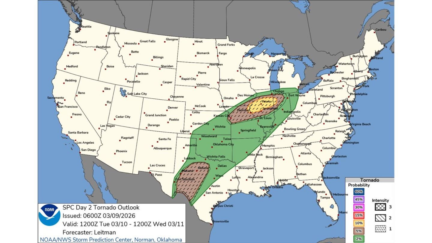
UNITED STATES — The latest Day 2 outlook for Tuesday, March 10, signals an increasingly concerning severe weather setup stretching from Texas through Missouri, Illinois and Indiana, where a 10% significant (EF2+) tornado risk has been outlined.
Forecasters indicate that atmospheric conditions will favor discrete supercells during the late afternoon and evening hours before storms eventually consolidate into a larger, more widespread wind event.
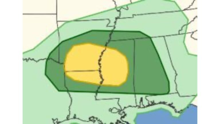
10% Significant Tornado Risk Highlighted
The Storm Prediction Center has placed a 10% probability area for significant tornadoes (EF2 or stronger) across parts of:
- Eastern Missouri
- Central and northern Illinois
- Western and central Indiana
Cities near the core of this zone include:
- Peoria, IL
- Springfield, IL
- Chicago, IL
- St. Louis, MO
- Indianapolis, IN
This corridor represents the area where storms interacting with a frontal boundary and remaining within the warm sector may have the greatest tornado potential.
Texas Also in the Tornado Picture
Farther south, another concentrated tornado risk area extends across portions of west and southwest Texas, including areas near:
- Midland
- Abilene
- Fort Stockton
This region may see supercells developing along a dryline as a trough ejects eastward, creating an additional severe threat separate from the Midwest focus.
Setup: Capping, Instability and Supercells
Forecast guidance suggests that strong capping will suppress storm development through much of the daytime hours Tuesday. This delay is important — it allows for:
- Continued heating
- Increasing instability
- Moisture return across the warm sector
By evening, the cap is expected to weaken enough for storms to rapidly develop. When they do, the environment will favor organized supercells capable of:
- Large hail
- A few significant tornadoes
- Damaging winds
Storms that form along and south of the frontal boundary and remain surface-based will pose the highest tornado risk.
Transition to a Linear Wind Event
As the evening progresses, initial discrete supercells are expected to grow upscale. This evolution could result in a more organized squall line, increasing the threat for:
- Widespread damaging winds
- Embedded tornadoes
This transition means that even areas outside the highest tornado probability zone may still experience impactful severe weather.
Timing: Late Afternoon Through Overnight
The most critical window appears to be:
- Late Tuesday afternoon
- Evening hours
- Potentially into the overnight period
Missouri, Illinois and Indiana are likely to see peak severe potential during the evening hours, while Texas storms may develop earlier in the afternoon and continue after dark.
Widespread Impact Zone
The broader severe risk area spans from:
- Texas
- Oklahoma
- Missouri
- Illinois
- Indiana
- Into parts of Michigan
While the 10% significant tornado risk marks the highest concern, surrounding areas remain at risk for severe thunderstorms capable of producing large hail and damaging winds.
Bottom Line
Tuesday’s setup presents a multi-state severe weather outbreak with the potential for supercells producing large hail and a few significant tornadoes from Texas through Missouri, Illinois and Indiana. As storms evolve, a larger-scale wind event may develop into the night.
Residents across the highlighted regions should closely monitor forecast updates and ensure they have multiple ways to receive weather alerts as Tuesday approaches. CabarrusWeekly.com will continue to track developments as details become clearer.