Strong Tornadoes Strike Northern Oklahoma as SPC’s CIG 1 Risk Proves Its Purpose in Conditional Severe Setup
OKLAHOMA — Several strong and large tornadoes developed across northern Oklahoma Thursday, validating the Storm Prediction Center’s relatively new “CIG 1” tornado risk designation — even in what many considered a conditional severe weather environment.
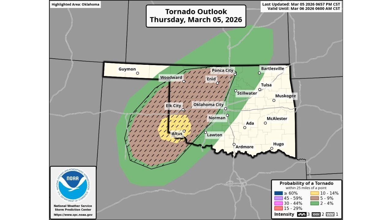
The Tornado Outlook issued for March 5 highlighted much of western and central Oklahoma, including cities such as Elk City, Woodward, Enid, Oklahoma City, Norman, and Altus, within a hatched tornado probability zone. That hatching is used to signal the potential for strong (EF2+) tornadoes.
What the Outlook Showed
The SPC outlook outlined:
- A broad tornado risk area covering western and central Oklahoma
- A hatched region stretching from near Altus and Elk City northeast toward Enid and Ponca City
- Inclusion of the Oklahoma City metro within the enhanced tornado probability zone
The “CIG 1” category — introduced to highlight environments capable of producing strong tornadoes even when overall coverage may be limited — was in place.
While the 10% tornado probability contour did not verify uniformly across the entire area, several significant tornadoes did occur in northern Oklahoma, underscoring the reasoning behind the designation.
Conditional, But Not Harmless
Forecast discussions prior to the event described the setup as conditional. That means storm development depended heavily on specific atmospheric triggers — such as storm timing, cap strength, and localized instability.
In conditional setups:
- Storms may be fewer in number
- Coverage may not be widespread
- But any storm that does form can become intense
That appears to be exactly what unfolded. Rather than a widespread outbreak, isolated but powerful supercells developed in northern portions of the state.
Why CIG 1 Matters
The Conditional Significant (CIG) tornado category was created to address scenarios where:
- Environmental parameters support strong tornado potential
- Storm coverage remains uncertain
- Risk messaging needs to emphasize impact over coverage
Thursday’s event demonstrated that even when a 10% probability area does not verify in a broad statistical sense, the potential for strong tornadoes can still be realized within parts of the outlined zone.
Communities near Enid, Ponca City, and areas north of Oklahoma City were among those most impacted.
Lessons From the Event
This case highlights a critical point in severe weather forecasting:
Not all high-impact days are widespread outbreak days.
Sometimes, the atmosphere produces fewer storms — but those storms are capable of producing significant damage.
For emergency managers and residents, that distinction is important. Lower coverage does not mean lower impact.
Looking Ahead
As spring severe weather season continues across the Plains, events like this reinforce the importance of paying attention to hatched tornado areas and conditional risk designations.
CabarrusWeekly.com will continue covering major severe weather developments across the country and breaking down what they mean — not just in terms of probability, but in terms of real-world impact.