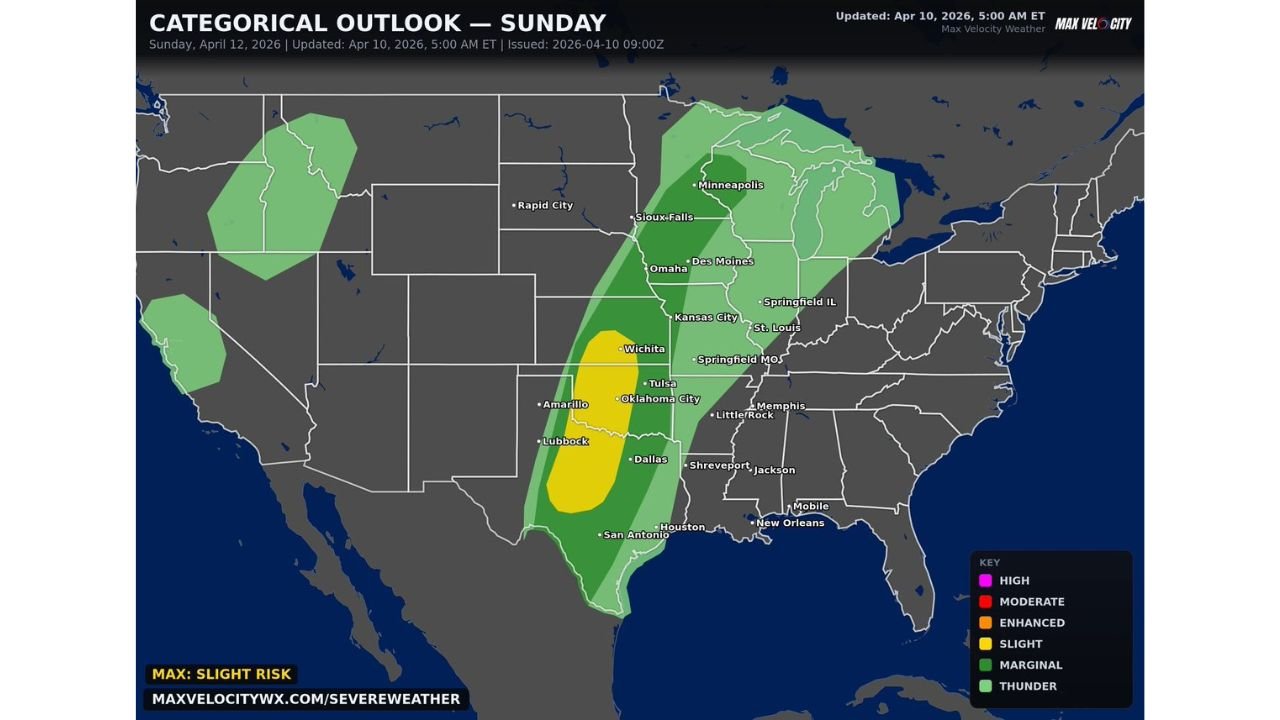
Sunday Severe Storm Threat Builds From North Texas Through Oklahoma Into Kansas With Large Hail, Damaging Winds and Isolated Tornado Risk Along I-35 Corridor
KANSAS — A widespread severe weather threat is expected to develop Sunday across the Plains, with multiple rounds of storms possible and increasing potential for damaging impacts.
Large Portion of Plains Under Severe Weather Risk
The overall setup places a broad region under storm risk, extending from Texas through Oklahoma and into Kansas, with additional surrounding areas also seeing thunderstorm activity.
This pattern suggests repeated storm development throughout the day, rather than a single isolated round, increasing the chances for widespread impacts.
Greatest Concern Along I-35 Corridor
The highest concern is centered from north Texas through Oklahoma into southern Kansas, including major cities such as Dallas, Oklahoma City, Tulsa, and Wichita.
This corridor, especially areas along and just west of the I-35 corridor, will be in the most favorable zone for stronger storm development during the afternoon and evening.
Storms May Become More Organized Later in the Day
Storms are expected to intensify as the day progresses, with greater organization developing during the afternoon into evening hours.
As storms organize, they will be more capable of producing larger hail and stronger wind gusts, particularly in areas where storms remain sustained over time.
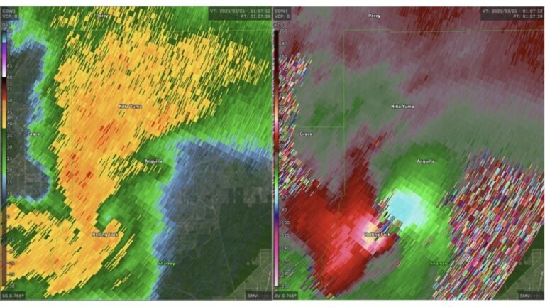
Large Hail and Damaging Winds Primary Threats
The main hazards with Sunday’s storms include very large hail and damaging winds, especially within the stronger storm cores.
Conditions across the region will support elevated hail potential, making this one of the more notable threats for the day.
Isolated Tornado Risk Cannot Be Ruled Out
In addition to hail and wind, a few tornadoes are possible, particularly within more organized storm structures.
While the tornado threat is not the primary concern, it remains a risk in areas where storms develop stronger rotation.
Multi-Round Storm Pattern Increases Impact Potential
The potential for multiple rounds of storms means some areas could experience repeated impacts, including accumulating damage or prolonged severe weather conditions.
This type of setup increases overall risk, as storms may redevelop over similar areas.
What to Expect and How to Prepare
The most active period is expected from afternoon through late evening, when storms are likely to be strongest and most widespread.
Residents across north Texas, Oklahoma, and southern Kansas should stay alert for warnings and be prepared for rapidly changing weather conditions, especially near the I-35 corridor.
Stay with CabarrusWeekly.com for continued updates, and share what conditions you are seeing in your area as severe storms develop Sunday.