Supercell Development Expected Friday Evening Across Texas Panhandle and Western Oklahoma With Increasing Strong Tornado Potential
TEXAS & OKLAHOMA — Confidence is increasing in a focused supercell development zone Friday evening across the Texas Panhandle and western Oklahoma, where atmospheric conditions appear supportive of tornado-producing storms.
Latest high-resolution model guidance shows agreement that storms will initiate near the Texas–Oklahoma border region before tracking east or northeast.
Where Storms Are Expected to Fire
Model projections indicate discrete supercells developing across:
- The Texas Panhandle
- Western Oklahoma
- Areas near the Oklahoma state line
Storm clusters appear initially isolated, which is a key factor in tornado potential.
If storms remain separated rather than forming into a solid line too quickly, the environment would favor rotating updrafts.
Differential Heating Boundary May Play a Role
Cloud cover positioned just north of the anticipated storm zone could create a differential heating boundary (DHB).
This boundary could sharpen low-level wind shear and enhance rotation if storms track along or just south of it.
Areas of particular interest include:
- Western Oklahoma counties near the Panhandle border
- Northern Texas Panhandle communities
Storms that “root” along this boundary would have a greater chance of producing tornadoes.
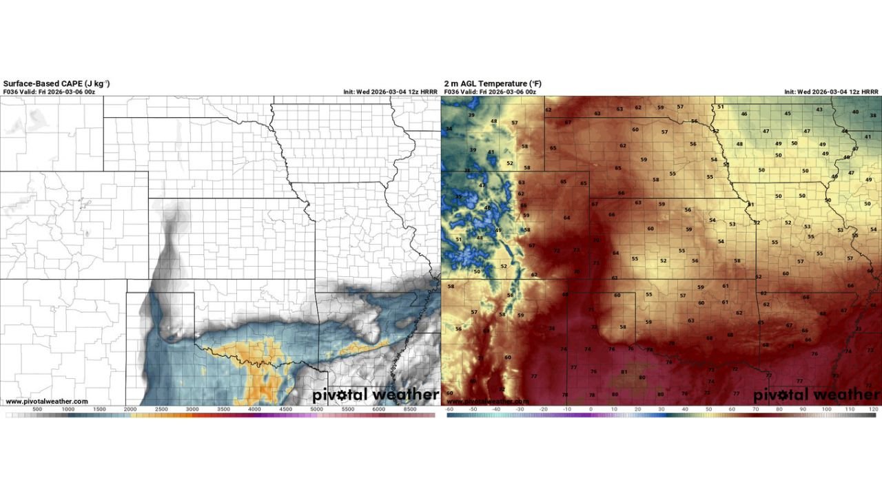
Strong Instability and Increasing Wind Energy
Forecast data suggests:
- Strong surface-based instability developing into the evening
- Temperatures rising into the 70s across portions of Texas and Oklahoma
- Increasing wind shear as upper-level energy approaches
A 700 mb shortwave moving into the region is expected to help break the cap and allow storms to initiate.
However, once storms begin to grow and potentially merge, they may quickly transition toward a hail-dominant phase.
Short Window for Tornado Production
The setup suggests there could be:
- A relatively short but potentially intense tornado window
- A transition toward large hail and damaging winds as storms upscale
If discrete supercells can remain intact during peak instability and shear overlap, the potential for a strong tornado would increase.
What This Means for Residents
Communities across:
- The Texas Panhandle
- Western Oklahoma
- Nearby border regions
should remain alert Friday afternoon and evening.
Key threats include:
- Tornadoes
- Very large hail
- Damaging winds
Storm evolution will determine how long tornado-favorable conditions persist before storms cluster.
CabarrusWeekly.com will continue monitoring forecast updates as this developing severe weather setup approaches.