Supercells, Big Hail, and Tornadoes: Tuesday Is Shaping Up as a Dangerous Severe Weather Day from Texas and Oklahoma All the Way to the Great Lakes
UNITED STATES — Tuesday April 14, 2026 is shaping up to be a rough and potentially dangerous severe weather day across a long corridor of the country. Supercells look likely along the dryline to the west, carrying a real shot at big hail and a tornado or two, with the threat pushing northeast into the evening hours. If you live anywhere in the affected zone, forecasters are urging you to prepare now — before Tuesday arrives.
A Long and Threatening Corridor from the Southern Plains to the Great Lakes
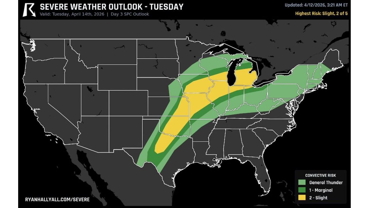
The SPC Day 3 Severe Weather Outlook, valid Tuesday April 14, 2026 and updated April 12, 2026 at 3:21 AM ET, places the highest risk at a Slight Risk — Level 2 of 5. But the geography of this threat is what stands out. The severe weather corridor stretches from Texas and Oklahoma in the south all the way northeast through the Plains, the Midwest, and into the Great Lakes region — a sweeping, multi-state threat that will evolve and push northeast as the day goes on into the evening.
Risk Zones for Tuesday April 14
| Risk Level | Areas and Cities Covered |
|---|---|
| Slight Risk — Level 2/5 | Central and southern Plains through the Midwest, Great Lakes corridor including Michigan |
| Marginal Risk — Level 1/5 | Texas, Oklahoma, surrounding Plains states, Ohio Valley, western Pennsylvania, western New York |
| General Thunder | Broader surrounding areas on the outer edges of the corridor |
The Slight Risk zone forms the core threat area, running in a defined diagonal band from the southern Plains northeast toward the Great Lakes. The Marginal Risk zone fans out on both sides, covering a wide swath of the country from Texas in the south to portions of the Northeast.
Supercells Along the Dryline Are the Primary Concern
The headline threat on Tuesday is supercell development along the dryline across the western portion of the corridor. The atmospheric setup is favorable for discrete, organized supercell thunderstorms — and those storms carry the full suite of severe weather hazards.
The specific threats forecasters are highlighting for Tuesday include:
- Large hail — a real shot at big hail from supercells firing along the dryline
- Tornadoes — a tornado or two possible from sustained supercells in the right environment
- Damaging winds — a threat across the broader corridor as storms organize and push northeast
The dryline across Texas and Oklahoma is where storm initiation is expected to begin, with supercells firing and then the threat pushing northeast into the evening — meaning the severe weather timeline extends well beyond the afternoon hours for areas further up the corridor.
The Threat Pushes Northeast Through the Evening
This is not a storm system that ends at sunset. The threat is expected to push northeast into the evening hours, which means cities and communities across the Midwest and Great Lakes region need to remain weather-aware well into Tuesday night. Evening and nighttime severe weather events are historically more dangerous because residents are less likely to be actively monitoring conditions.
The progression of the threat from the southern dryline in Texas and Oklahoma northeast through the Plains and into the Great Lakes means that different parts of the corridor will face their greatest risk at different times throughout Tuesday and into Tuesday evening.
What You Need to Do Before Tuesday Arrives
Forecasters are delivering a direct and urgent message to anyone living in the affected zone — prepare today, not Tuesday morning.
- Check your weather radio batteries right now and make sure your radio is functional and programmed for your county
- Know where you are going if a tornado warning is issued for your area — identify your safe shelter location before the storms arrive
- Download a weather alert app and ensure notifications are turned on for severe thunderstorm and tornado warnings
- Have a plan for the evening hours — the threat does not end at sunset and nighttime warnings require you to already know what to do
Tuesday Severe Weather Outlook at a Glance
| Factor | Details |
|---|---|
| Valid date | Tuesday April 14, 2026 |
| Highest risk level | Slight — Level 2 of 5 |
| Primary threat area | Texas and Oklahoma north through the Plains to the Great Lakes |
| Storm type | Supercells along the dryline |
| Key hazards | Big hail, tornadoes, damaging winds |
| Timing | Afternoon initiation, pushing northeast into the evening |
| Updated | April 12, 2026 at 3:21 AM ET |
Do Not Wait Until Tuesday Morning to Take This Seriously
The setup is clear, the corridor is defined, and the hazards are well-identified. Supercells along the dryline from Texas and Oklahoma carry a real and legitimate threat of large hail and tornadoes, and as that energy pushes northeast through the day and into the evening, the Great Lakes region faces its own elevated risk from the same system.
Check your weather radio today. Know your shelter plan today. Talk to your family about what to do if a warning drops today — because by the time Tuesday’s storms are firing, the time for preparation will already be gone.
Stay with CabarrusWeekly.com for live Tuesday severe weather coverage, tornado and severe thunderstorm warnings as they are issued, and storm reports across the entire corridor from Texas to the Great Lakes.