Supercells Explode Across Southern Oklahoma: Large Hail Hammering Near Pauls Valley and Sulphur as Tornado Risk Expected to Rise Into Evening
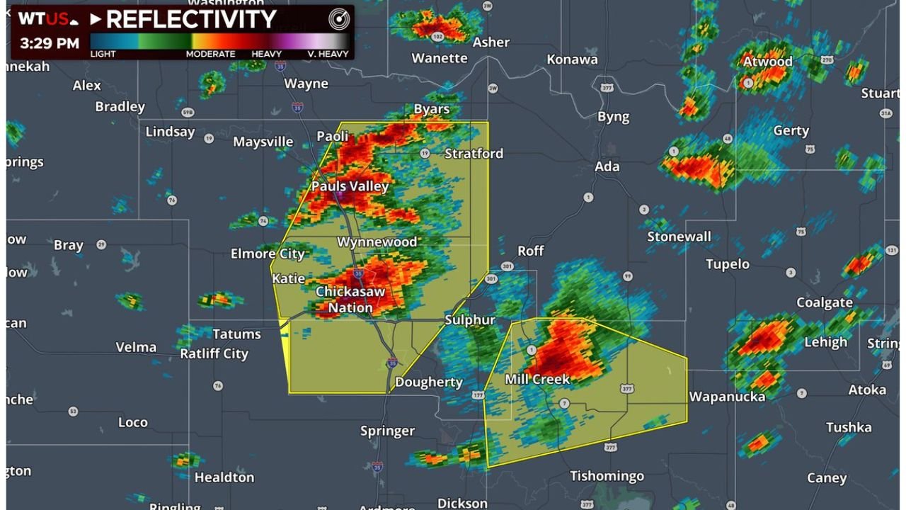
OKLAHOMA — Supercells are rapidly developing across Southern Oklahoma this afternoon, with storms intensifying near Pauls Valley, Wynnewood, Chickasaw Nation, and Sulphur.
Radar imagery shows multiple rotating cells producing strong reflectivity cores, a clear indication that large hail is currently the primary hazard. However, forecasters warn that the tornado threat is expected to increase over the next few hours as the environment becomes more favorable for rotation.
Current Storm Focus
The strongest storms are concentrated across:
- Pauls Valley
- Wynnewood
- Elmore City
- Chickasaw Nation
- Sulphur
- Mill Creek
Additional developing cells are noted farther east near Atwood, Coalgate, and Lehigh.
Several of these storms are already prompting warnings as they track northeast across the region.
Main Hazard Right Now: Large Hail
The dominant threat this afternoon is large hail, with intense storm cores visible on radar. Supercells in this region are capable of producing hail large enough to cause damage to vehicles, roofs, and crops.
Residents in the warned areas should remain indoors and move vehicles under shelter if possible.
Tornado Threat Increasing Toward Evening
While the tornado risk is not the primary concern at this moment, meteorologists caution that conditions are expected to become more supportive of tornado development later this afternoon and into the evening.
As:
- Low-level wind shear strengthens
- Storm interactions increase
- Atmospheric instability continues to build
The likelihood of rotating storms producing tornadoes will rise.
Areas from Pauls Valley and Wynnewood eastward toward Sulphur and Mill Creek will need to monitor storm evolution closely.
Storm Movement and Evening Outlook
Storms are expected to continue tracking northeast across Southern Oklahoma. Additional supercells may form ahead of or alongside the current activity.
If storms remain discrete rather than merging into a solid line, the tornado threat could become more pronounced before sunset.
Bottom Line
Supercells are already active across Southern Oklahoma, producing large hail near Pauls Valley and Sulphur. While hail remains the primary threat at this time, the tornado risk is expected to increase over the next few hours as we head into the evening.
Residents across Southern Oklahoma should stay weather aware and monitor warnings as this situation evolves.
CabarrusWeekly.com will continue tracking storm development through the evening.