Supercells Target Childress, Amarillo and Wichita Falls as Texas and Oklahoma Face Increasing Tornado Setup Thursday Evening
TEXAS & OKLAHOMA — Updated morning model data is sharpening the focus on a potentially volatile severe weather setup Thursday afternoon and evening across the Texas Panhandle and western Oklahoma, with particular attention on areas near Childress, Amarillo, Elk City and Wichita Falls.
Multiple high-resolution forecast models are now aligning on supercell development north of Childress, Texas, while additional guidance suggests storms could also initiate southwest of Wichita Falls as deeper moisture continues pushing northward.
Model Agreement Increasing Confidence
The 09z model suite shows growing agreement that supercells will develop across:
- Amarillo and Pampa, TX
- North of Childress, TX
- Near Elk City, OK
- Possibly southwest of Wichita Falls, TX
While some solutions focus storms closer to the Texas–Oklahoma border, others extend development slightly farther south depending on how quickly dew points recover.
Forecasters emphasize that surface observations will be critical throughout the day as moisture, cloud cover and temperature trends evolve.
Moisture and Instability Building
Surface observations show dew points climbing into the 60s across portions of north Texas and southern Oklahoma. Temperatures rising into the 70s across the southern Plains are increasing instability.
Forecast soundings from western Oklahoma indicate:
- Strong surface-based instability
- Favorable low-level wind shear
- Backed surface winds enhancing storm rotation potential
If storms can form in this environment before clustering, discrete supercells could produce tornadoes.
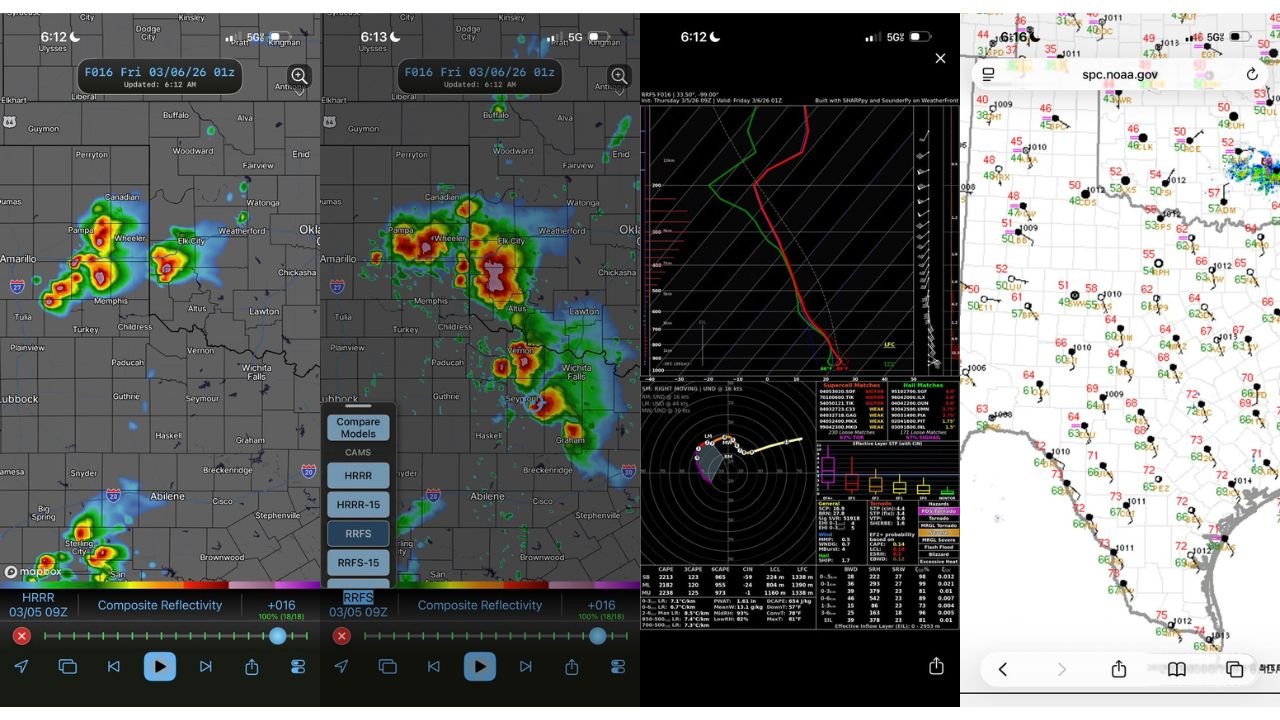
Radar Simulation Highlights Focus Zones
Composite reflectivity projections highlight initial storm development near:
- Amarillo and Canadian, TX
- Wheeler, TX
- West of Elk City, OK
- Later potential near Vernon and Wichita Falls, TX
Storms developing near differential heating zones or boundaries could intensify quickly.
What Could Make This Day “Cook”
Key ingredients include:
- Increasing low-level moisture
- Strong wind shear through the lowest 3 km
- Favorable supercell composite parameters
- Lift associated with approaching upper-level energy
If storm initiation occurs in the right corridor, the environment supports rotating updrafts capable of producing tornadoes, along with large hail and damaging winds.
However, small shifts in storm placement — even 20 to 40 miles — could dramatically change which communities see the highest risk.
Areas to Watch Closely
Residents in:
- Childress
- Amarillo
- Pampa
- Elk City
- Wichita Falls
- Surrounding Texas–Oklahoma border communities
should closely monitor updates through the afternoon and evening.
Forecast confidence in supercell development is increasing, but exact storm tracks will depend on surface boundaries and moisture return.
CabarrusWeekly.com will continue tracking this developing severe weather situation as conditions evolve across Texas and Oklahoma.