Tennessee, Kentucky and Northern Alabama in 15% Hatched Severe Risk Sunday Night as Nashville Region Braces for Potentially Intense Storms
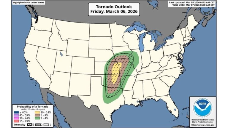
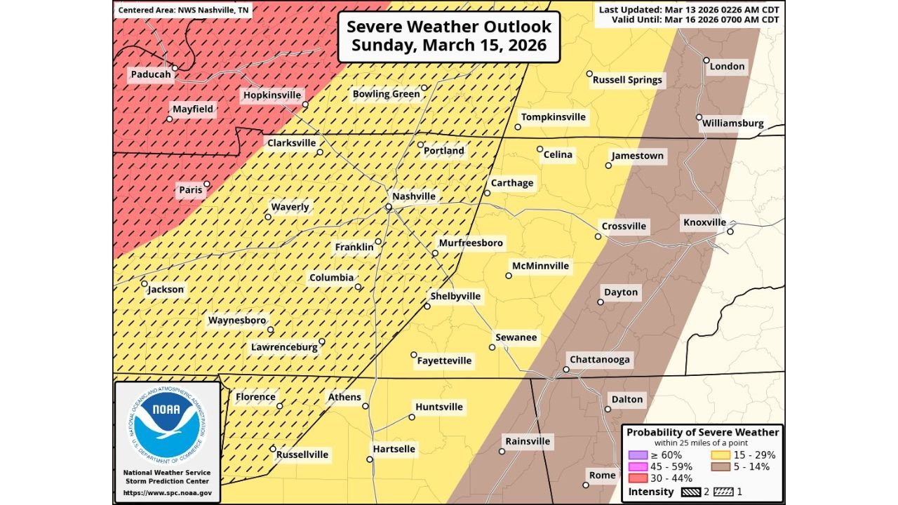
UNITED STATES — Severe weather chances are increasing for Sunday night, March 15, across portions of Tennessee, Kentucky and northern Alabama, where the Storm Prediction Center has outlined a 15% risk of severe storms within 25 miles of any point — including a hatched area that signals the potential for particularly intense storms.
The latest outlook, centered on the Nashville, Tennessee forecast area, places much of Middle Tennessee and adjacent areas in an elevated threat zone as a strong system approaches.
What the 15% Hatched Risk Means
A 15% probability means there is at least a 15% chance of severe weather — defined as damaging winds, large hail or tornadoes — occurring within 25 miles of a given location.
The addition of hatching is important. That designation highlights the possibility that storms could be stronger than typical marginal setups, potentially producing:
- More widespread damaging winds
- Larger hail
- A few stronger tornadoes
Communities under the hatched area include Nashville, Clarksville, Columbia, Franklin, Murfreesboro and Bowling Green, Kentucky, as well as areas stretching south toward Florence, Alabama.
Areas Included in the Risk
The highest concern extends across:
- Western and Middle Tennessee, including Nashville and surrounding counties
- Southern and western Kentucky, including Hopkinsville and Bowling Green
- Northern Alabama, including Florence and areas near the Tennessee border
To the east, cities such as Crossville, McMinnville and toward the Knoxville and Chattanooga corridors remain in a lower, but still notable, 5–14% severe probability zone.
Timing and Storm Mode
Storms are expected to develop and intensify Sunday evening into the overnight hours.
Given the strengthening wind fields associated with the approaching system, forecasters are monitoring for:
- Organized line segments capable of producing damaging straight-line winds
- Embedded circulations within a squall line
- Isolated supercells ahead of the main line
The combination of nighttime timing and increasing storm organization raises concerns for reduced visibility and shorter warning lead times.
Why This Setup Is Being Watched Closely
The broader pattern features a strengthening storm system tracking through the central United States and into the Tennessee Valley. As warm, moist air surges northward ahead of the cold front, instability will increase across Tennessee and Kentucky.
At the same time, wind speeds aloft will intensify, creating strong wind shear — a key ingredient for rotating storms.
When shear and instability overlap, the environment can support storms capable of producing damaging wind gusts and tornadoes, especially if discrete storms form before consolidating into a line.
What Residents Should Do
With severe weather chances increasing, residents across Tennessee, Kentucky and northern Alabama should:
- Review severe weather safety plans
- Ensure weather alerts are enabled on phones
- Identify a safe interior room away from windows
- Monitor forecast updates throughout Sunday
Because the event is expected to unfold after dark for many locations, having multiple ways to receive warnings will be critical.
Bottom Line
A 15% hatched severe weather risk for Sunday night signals that Tennessee, Kentucky and northern Alabama could see not just scattered severe storms — but potentially intense ones.
Forecast details will continue to be refined, but the environment is trending in a direction that warrants heightened awareness across the Nashville region and surrounding communities.
CabarrusWeekly.com will continue monitoring updates as Sunday approaches and provide additional timing and impact details as new information becomes available.