Tennessee, Mississippi, Alabama, Georgia, Florida, and Indiana Face Overnight Severe Storm Threat as Squall Line Brings 75 MPH Winds and Tornado Risk
MISSISSIPPI VALLEY — A powerful line of severe thunderstorms is expected to sweep across parts of Tennessee, Mississippi, Alabama, Georgia, Florida, and Indiana late Sunday night into early Monday morning, bringing damaging winds up to 75 mph and the potential for tornadoes as storms rapidly track east through the region.
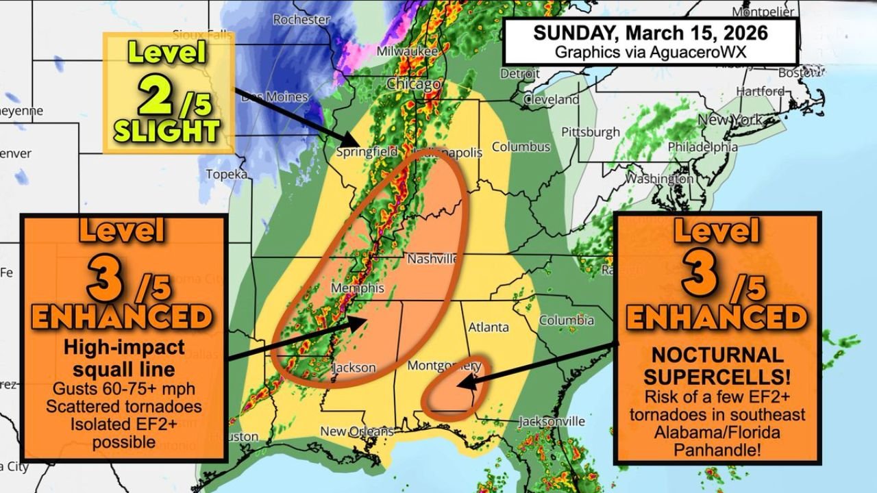
High-Impact Squall Line Expected From Mississippi Into Tennessee
Meteorologists are closely monitoring a large, organized squall line forming across the lower Mississippi Valley Sunday evening that is expected to intensify as it pushes northeast overnight.
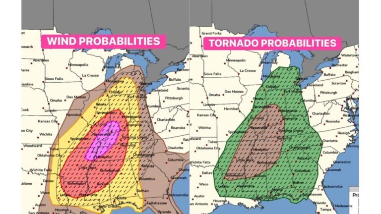
The greatest threat stretches from northern Mississippi through western Tennessee and into southern Indiana, including areas near Memphis, Nashville, and portions of the Ohio Valley. In this corridor, forecasters have issued an Enhanced Risk (Level 3 out of 5) for severe weather.
The main hazard will be powerful straight-line winds between 60 and 75 mph, capable of bringing down trees, damaging roofs, and causing scattered power outages.
Storm experts say the line of thunderstorms could become particularly dangerous as it organizes into a fast-moving system capable of producing widespread wind damage along its leading edge.
Tornadoes Possible Within the Fast-Moving Storm Line
While damaging winds remain the primary concern, tornadoes are also possible within the storm line, particularly across parts of Mississippi and Tennessee where atmospheric conditions favor rotating storms embedded within the squall line.
These tornadoes can form quickly along the leading edge of the storms and sometimes occur with little warning. Forecast guidance suggests a few stronger tornadoes, potentially reaching EF2 intensity, cannot be ruled out in isolated cases.
Because the system will be moving rapidly, communities could experience very sudden weather changes as the storms arrive overnight.
Secondary Tornado Threat Across Alabama, Georgia, and the Florida Panhandle
A second area of concern is developing farther southeast across southeast Alabama, extreme southwest Georgia, and the Florida Panhandle, where meteorologists are watching for isolated nocturnal supercells late Sunday night into early Monday morning.
In this region, increasing moisture from the Gulf of Mexico may combine with strengthening winds in the atmosphere to produce rotating thunderstorms capable of tornadoes.
Although storms here may be more scattered than the squall line farther north, forecasters say a few storms could become intense enough to produce EF2-level tornadoes before sunrise Monday.
The fact that these storms may develop overnight increases the danger, since nocturnal tornadoes often occur when many people are asleep.
Storms Could Race East at Highway Speeds
Another major concern with this system is how quickly the storms will move across the region.
Meteorologists say the squall line may travel eastward at highway speeds, meaning conditions could deteriorate rapidly once storms approach.
Residents may first experience increasing winds, heavy rainfall, and frequent lightning, followed by a sudden burst of damaging winds as the main storm line moves through.
These fast-moving systems are known for producing widespread wind damage over large areas in a short amount of time.
Midwest Areas Including Indiana Under Slight Severe Risk
While the strongest storms are expected across the Mississippi Valley and Southeast, the severe weather risk extends northward into parts of the Midwest.
A Slight Risk (Level 2 out of 5) area covers portions of Illinois and Indiana, where thunderstorms could still produce gusty winds and isolated severe weather as the storm system advances east.
Although tornado risk in these areas appears lower, meteorologists say strong storms capable of damaging wind gusts are still possible.
Overnight Preparedness Will Be Critical
Because many of the strongest storms are expected late Sunday night into early Monday morning, forecasters emphasize the importance of having multiple ways to receive weather alerts overnight.
Weather radios, mobile alerts, and local warning systems can help ensure residents are awakened if severe thunderstorm or tornado warnings are issued while people are sleeping.
Residents in Tennessee, Mississippi, Alabama, Georgia, Florida, and Indiana should remain weather aware and be ready to move to shelter quickly if warnings are issued overnight.
Weather graphics and risk zones referenced in this report were compiled using meteorological briefing material.
Stay with CabarrusWeekly.com for continuing updates as this severe weather system develops and moves across the region. If storms impact your area, share your local conditions with the CabarrusWeekly.com community to help others stay informed.