Texas Hill Country Temperatures Dip to Near Freezing Sunday and Monday, With San Antonio Area Facing Light Freeze Risk
TEXAS — A colder-than-expected model run is raising new concerns about near-freezing temperatures across parts of the Texas Hill Country and the greater San Antonio region early Sunday and again Monday morning, with some spots potentially seeing a light freeze.
According to the latest in-house computer guidance, temperatures may run slightly colder than other forecast models suggest — enough to prompt plant protection in some communities.
Sunday Morning: Hill Country Near the Freezing Mark
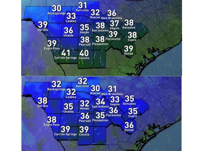
Forecast temperatures for 7:00 a.m. Sunday show the coldest readings concentrated in the Hill Country:
- Rocksprings: 30°F
- Kerrville: 31°F
- Boerne: 32°F
- Leakey: 33°F
- Uvalde: 36°F
- Hondo: 35°F
San Antonio is projected to start the morning around 38°F, while New Braunfels may see 36°F.
Communities farther south and east, including Gonzales (38°F), Cuero (38°F), Goliad (39°F), and Carrizo Springs (41°F), are expected to remain above freezing but still cold.
Forecasters note that while most areas will stay just above 32°F, isolated colder pockets in the Hill Country could briefly dip to freezing, prompting a recommendation to protect sensitive plants.
Monday Morning: Even Colder With Lighter Winds
The bigger concern may come Monday morning, when lighter winds could allow for more efficient radiational cooling.
Projected 7:00 a.m. Monday temperatures include:
- Boerne: 30°F
- Kerrville: 32°F
- Leakey: 32°F
- Hondo: 32°F
- San Antonio: 34°F
- New Braunfels: 31°F
- Seguin: 33°F
Outlying colder spots in northern Bexar County and typical low-lying areas could briefly touch freezing under calm conditions.
Meanwhile, Del Rio and Eagle Pass are forecast near 38°F, and Carrizo Springs and Cotulla around 39°F, staying above the freeze threshold.
What This Means for Residents
While this does not appear to be a widespread hard freeze event, the colder model solution has raised enough concern for residents in the Hill Country and northern Bexar County to consider precautionary steps.
Suggested actions include:
- Covering potted plants Sunday night
- Bringing sensitive vegetation indoors
- Monitoring updated forecasts for any downward adjustments
Forecasters emphasize this is not a guaranteed freeze scenario but rather a “better safe than sorry” setup as meteorological spring approaches.
Small changes in wind speed or cloud cover could determine whether temperatures hover just above freezing or briefly slip below 32°F in isolated spots. For the latest regional weather updates and temperature trends — even beyond the Carolinas — stay connected with CabarrusWeekly.com for ongoing coverage and forecast analysis.