Texas, Oklahoma and Kansas Face Rare Four-Day Tornado and Severe Storm Outbreak April 11-14 Targeting Dallas, OKC, Wichita and Tulsa
UNITED STATES — A rare and significant severe weather signal is emerging for the south-central United States. The Storm Prediction Center has issued extended-range outlooks for four consecutive days — Saturday, April 11 through Tuesday, April 14, 2026 — a level of advance confidence that forecasters say is seen only a couple of times per year, if that.
Widespread severe weather including tornadoes, large hail, and damaging winds is expected each day across a shifting corridor from west Texas through Oklahoma, Kansas, and into the Midwest. Dallas, Oklahoma City, Wichita, Tulsa, and Joplin are forecast to be in the bullseye for two to three consecutive days — an unusually direct and sustained threat for some of the most populated cities in the southern Plains.
Why This Outbreak Is Rare
Extended-range severe weather outlooks at the Day 4-7 range are not common. When the Storm Prediction Center issues them with this level of confidence across four consecutive days, it signals that the atmospheric pattern is unusually well-defined and consistent across multiple forecast models.
Forecasters are specifically noting that this level of confidence this far in advance is something seen only a handful of times each year. The atmospheric ingredients — Gulf moisture, upper-level energy, and wind shear — are aligning in a way that is difficult to ignore even at this extended range.
How the Four-Day Outbreak Unfolds
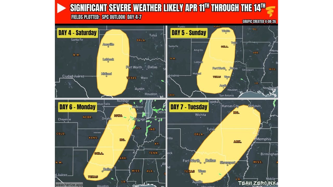
Saturday, April 11 — West Texas Opens the Stretch
The outbreak begins across west Texas — centered over the Amarillo, Lubbock, and Midland corridor. A classic dryline setup across the Texas Panhandle will be the primary trigger for storm development Saturday afternoon. Storms firing along this boundary will have access to deep Gulf moisture already building across the region.
Cities in Saturday’s risk zone include:
- Amarillo
- Lubbock
- Midland
- Odessa
- Fort Worth and Dallas on the eastern fringe
Sunday, April 12 — Oklahoma and Kansas Move Into the Bullseye
The risk zone shifts northeastward on Sunday — placing Oklahoma and Kansas directly in the highest-risk corridor. This is the first of potentially two to three consecutive threat days for Oklahoma City, Tulsa, and Wichita.
Cities in Sunday’s risk zone include:
- Wichita
- Tulsa
- Oklahoma City
- Fort Worth
- Dallas
- Lubbock on the western fringe
Monday, April 13 — The Largest and Most Widespread Day
Monday carries the biggest geographic footprint of the four-day outbreak — expanding dramatically northward into Nebraska, Iowa, Illinois, and Indiana while maintaining coverage across Kansas, Oklahoma, Missouri, Arkansas, Tennessee, and Texas. This is the day where the severe weather threat reaches its maximum geographic extent.
Cities and states in Monday’s risk zone include:
- Omaha and eastern Nebraska
- Iowa — Des Moines corridor
- Chicago and northern Illinois
- Indiana
- Kansas City and Missouri
- Oklahoma City and Tulsa — again
- Dallas — again
- Arkansas and Tennessee
- Louisiana and Alabama on the southern fringe
Tuesday, April 14 — Southeast Corridor Closes the Stretch
The outbreak concludes Tuesday with the risk zone shifting eastward and southward into Missouri, Arkansas, Oklahoma, Texas, and Mississippi. By Tuesday the pattern has pushed through the heart of the southern Plains and is delivering its final significant severe weather day across the mid-South corridor.
Cities in Tuesday’s risk zone include:
- Kansas City
- Wichita — potentially third consecutive day
- Tulsa — potentially third consecutive day
- Oklahoma City
- Fort Worth and Dallas
- Shreveport
- Memphis fringe
Dallas, OKC, Wichita and Tulsa — 2 to 3 Days in the Bullseye
One of the most striking aspects of this four-day outlook is the degree to which the same cities face repeated direct threats on consecutive days.
Oklahoma City, Tulsa, and Wichita are each forecast to be within the primary risk zone on Sunday, Monday, and potentially Tuesday — three consecutive days of organized severe weather potential. Dallas and Fort Worth face a similar pattern across Saturday, Sunday, and Monday.
When major urban areas sit in the bullseye for two to three consecutive severe weather days, the cumulative risks go well beyond any single storm event:
- Power outages from one day compound into the next before crews can restore service
- Emergency response resources face sustained demand with no recovery window
- Rainfall from multiple storm days saturates the ground and raises flash flood risk with each new system
- Severe weather fatigue — residents letting their guard down after surviving the first day — becomes a genuine safety concern heading into subsequent days
Primary Hazards Each Day
Across all four days the threat profile includes:
- Tornadoes — including the potential for significant tornadoes given the level of atmospheric organization forecast
- Large hail — potentially very large hail with the strongest supercell thunderstorms
- Damaging wind gusts of 60 mph or greater, especially as storms organize into lines and clusters
- Heavy rainfall and flash flooding concerns given the multi-day nature of the pattern
Forecast Confidence Level
High confidence on severe weather development across all four days — the SPC issuing Day 4-7 extended outlooks with this level of organization reflects unusually strong forecaster confidence for this time range.
High confidence on the geographic progression from west Texas Saturday through the Southeast by Tuesday** — the upper-level pattern driving this outbreak is well-defined and consistent.
Medium confidence on exact storm intensity and tornado potential each day** — specific details including EF-scale potential, exact hail sizes, and precise storm tracks will become significantly clearer by Wednesday and Thursday as each day enters the reliable short-range forecast window.
What Residents Must Do Before Saturday
Oklahoma City, Tulsa, Wichita, and Dallas residents face the most direct and sustained threat of any cities in this outbreak — with two to three consecutive risk days targeting their communities. Preparation must begin now, not Friday night.
Residents across the entire four-day risk corridor should:
- Identify and physically walk through your tornado shelter location — do not just know where it is, make sure it is accessible and ready
- Charge all devices and backup batteries before Saturday morning
- Assemble a severe weather kit with water, food, medications, a flashlight, and a battery-powered weather radio
- Know your flood evacuation route — heavy multi-day rainfall will raise flash flood risk across the entire corridor by Monday and Tuesday
- Make a communication plan with family members so everyone knows where to go and how to check in if cell service is disrupted
- Monitor SPC outlooks daily through the week as confidence increases and specific risk upgrades are issued
Cabarrus Weekly Perspective
The Storm Prediction Center does not issue four consecutive extended-range severe weather outlooks lightly. The fact that this level of confidence exists this far in advance — for four straight days across the same general corridor — is a signal that the atmosphere is setting up for something genuinely significant across the southern Plains and Midwest.
Dallas, OKC, Wichita, and Tulsa sitting in the bullseye for two to three consecutive days is the detail that demands the most attention. Multi-day direct threats to major urban areas create compounding risks that go beyond what any single outbreak would produce.
The specific details — exact tornado probabilities, hail sizes, and storm timing — will sharpen dramatically by midweek as the event comes into closer range. But the overall signal is clear enough right now to begin serious preparation across every community in the risk zone.
Do not wait for a watch to be issued Saturday to start getting ready. Start today.
Stay ahead of dangerous weather before it reaches your door. Visit cabarrusweekly.com for daily severe weather coverage, tornado outlooks, and storm alerts from across the United States — because knowing early is the difference that matters.