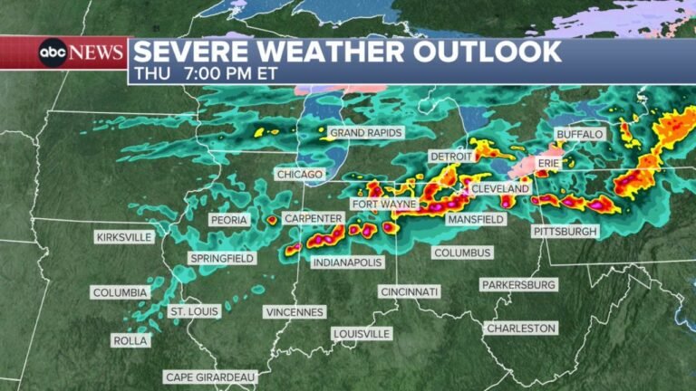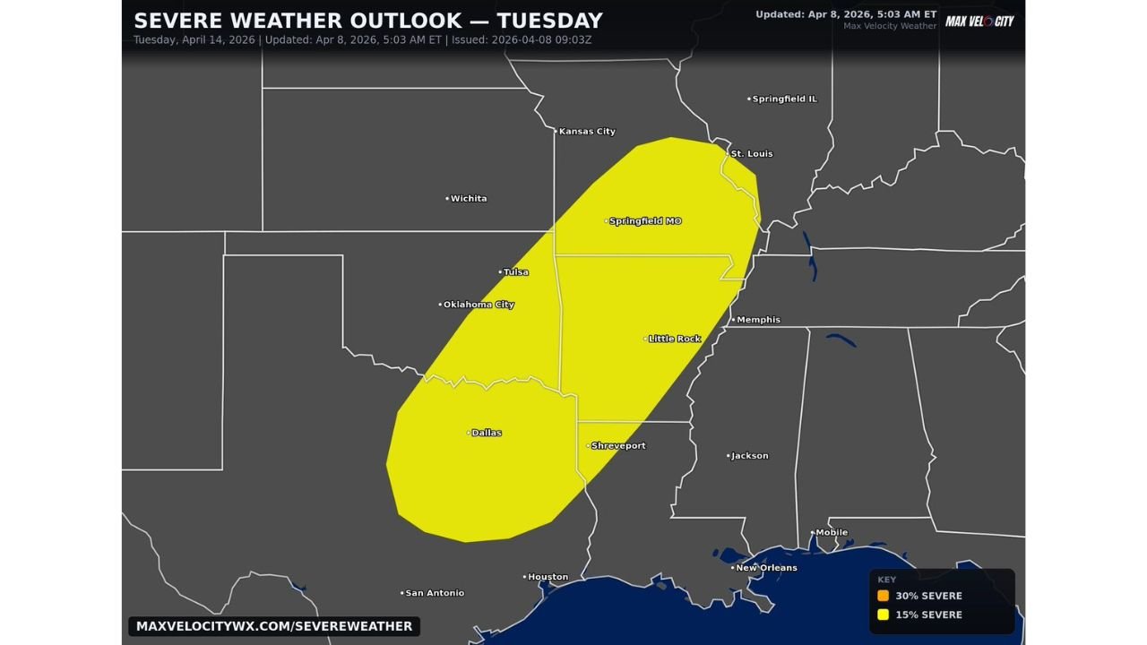
Texas, Oklahoma, Arkansas, Missouri and Illinois Face Growing Severe Storm Threat Tuesday With Tornadoes, Hail and Damaging Winds Possible
UNITED STATES — Confidence is increasing in a significant severe weather setup for Tuesday, April 14, with a broad risk zone stretching from Texas through Oklahoma, Arkansas, Missouri, and into Illinois.
Even though this system is still nearly a week away, forecast signals are becoming more consistent, pointing toward a potentially impactful day of severe storms across the central United States.
Expanding Risk Area From South to Midwest
The current outlook highlights a large corridor that includes:
- Dallas and North Texas
- Oklahoma City and much of Oklahoma
- Little Rock and central Arkansas
- Springfield, Missouri
- Areas approaching St. Louis and parts of Illinois
This northward extension of the risk zone shows that storms could track from the southern Plains into the Midwest, impacting multiple states in a single day.
Why Tuesday Looks More Concerning
Among the upcoming stretch of active weather days, Tuesday is already standing out due to:
- A larger and more organized risk area
- Increasing signs of strong atmospheric instability
- Favorable conditions for storm organization and severity
Forecast discussions indicate that this could be part of a “busy” severe weather period, with Tuesday potentially being one of the more active days in the sequence.
Primary Hazards Expected
If current trends continue, storms developing on Tuesday could bring:
- Damaging wind gusts capable of widespread impact
- Large hail, possibly significant in stronger storms
- Tornadoes, especially if discrete supercells form
The combination of these threats suggests a multi-hazard severe weather event, rather than isolated storms.
Part of a Larger Multi Day Severe Pattern
This Tuesday setup is connected to a broader pattern already developing across the country:
- A multi-day severe weather stretch beginning over the weekend
- Repeated rounds of storms shifting from Texas to the Midwest
- Increasing moisture and instability feeding each new wave of storms
This means some areas could see multiple rounds of severe weather within a short time frame.
Preparation Urged Across Impacted States
With major cities and densely populated areas within the risk zone, early awareness is critical.
Residents across Texas, Oklahoma, Arkansas, Missouri, and Illinois should:
- Review severe weather safety plans
- Stay updated with forecast changes over the coming days
- Be ready for rapidly changing conditions as Tuesday approaches
Cabarrus Weekly Perspective
When confidence begins to rise this far in advance, it is often a sign that the atmosphere is aligning for a more organized severe weather event.
While exact details will continue to evolve, Tuesday already stands out as a day to watch closely, especially given the wide geographic coverage and multiple hazards involved.
As this active pattern unfolds, early preparation and awareness will be key across the central United States.