Texas, Oklahoma, Arkansas, Tennessee, Georgia Face Growing Snow and Ice Threat as Euro Model Stays Consistent for This Weekend
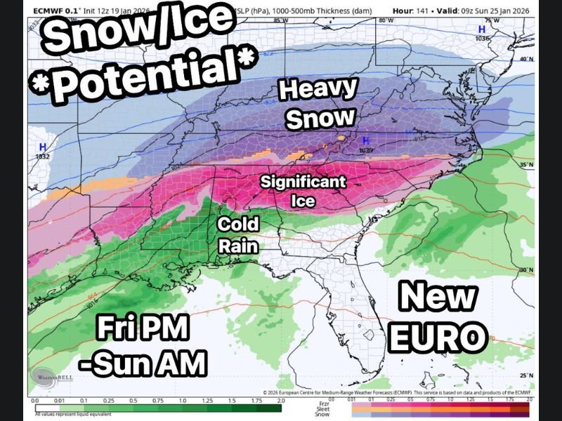
UNITED STATES — A high-impact winter storm signal continues to strengthen across a broad swath of the southern and eastern United States, with the latest European (Euro) model remaining consistent for a fourth consecutive run. The setup places Texas, Oklahoma, Arkansas, Tennessee, Alabama, Georgia, South Carolina, and North Carolina at varying risk for snow, sleet, freezing rain, and cold rain from Friday evening through early Sunday.
Why Meteorologists Are Taking This Signal Seriously
At roughly five days out, confidence is high that a storm system will be present and high that cold air will be available. Those two ingredients alone significantly raise concern. The primary uncertainty lies in the exact storm track, which will ultimately determine where snow dominates versus where ice becomes the main hazard.
A shift of just 30 to 40 miles north or south could dramatically change impacts for individual communities.
Snow Favored Across the Northern Impact Zone
Current Euro guidance supports heavier snow potential across Oklahoma, Arkansas, Tennessee, and parts of North Carolina, where colder air appears deep enough to support mainly snow. These areas could see accumulating snowfall capable of creating hazardous travel, especially if snow bands persist for several hours.
Ice Risk Grows Across the Deep South
Farther south, the Euro model continues to highlight greater ice potential across Alabama, Georgia, Mississippi, and South Carolina. In these areas, shallow cold air near the surface is expected to be overrun by warmer air aloft, a classic setup for freezing rain.
Even moderate ice accumulation can lead to downed trees, power outages, and extremely dangerous road conditions, making this zone particularly concerning.
Texas Sits at the Western End of the Threat
In Texas, impacts depend heavily on timing and cold air depth. Northern Texas may fall closer to the snow or ice transition zone, while central and eastern portions face a higher chance of freezing rain or cold rain, depending on how temperatures evolve during the event.
Southern Edge Could Be Cold Rain — or Much Worse
Across the southernmost parts of the system, including portions of southern Georgia and southern South Carolina, cold rain remains possible. However, this boundary is fragile, and minor temperature changes could quickly turn cold rain into freezing rain, increasing impacts.
Expected Timing: Friday Night Through Sunday Morning
The current window for impacts begins Friday evening, intensifies Friday night into Saturday, and may linger into early Sunday morning. The extended duration raises concern for compounding impacts, especially where ice persists through multiple temperature cycles.
What Happens Next
Over the next 48 hours, forecasters will focus on whether the Euro model’s signal strengthens, weakens, or shifts geographically. While details remain uncertain, the overall pattern strongly supports meaningful winter weather somewhere within this multi-state corridor.
What Residents Should Do Now
This is an early but credible signal, not a final forecast. Residents across Texas, Oklahoma, Arkansas, Tennessee, Alabama, Georgia, South Carolina, and North Carolina should begin considering travel plans, power preparedness, and schedule flexibility for the weekend.
Updates will continue as confidence increases and impact zones become clearer. Share what you’re seeing locally and stay informed with continued coverage at CabarrusWeekly.com.