Texas, Oklahoma, Arkansas, Tennessee, Illinois, Indiana, and Ohio Face Heavy Rainfall and Flooding Risk Over the Next Seven Days With Memphis, Indianapolis, Columbus, Chicago, and Nashville in the Heaviest Rainfall Zone
UNITED STATES — A significant and potentially dangerous heavy rainfall event is unfolding across the central and eastern United States over the next seven days. From Texas through the Mississippi Valley and up into the Great Lakes, accumulated rainfall totals of 2 to 6 inches are expected broadly, with locally higher amounts possible in the hardest-hit corridors. An increased risk of flooding is developing across multiple regions as this prolonged wet pattern takes hold through early April.
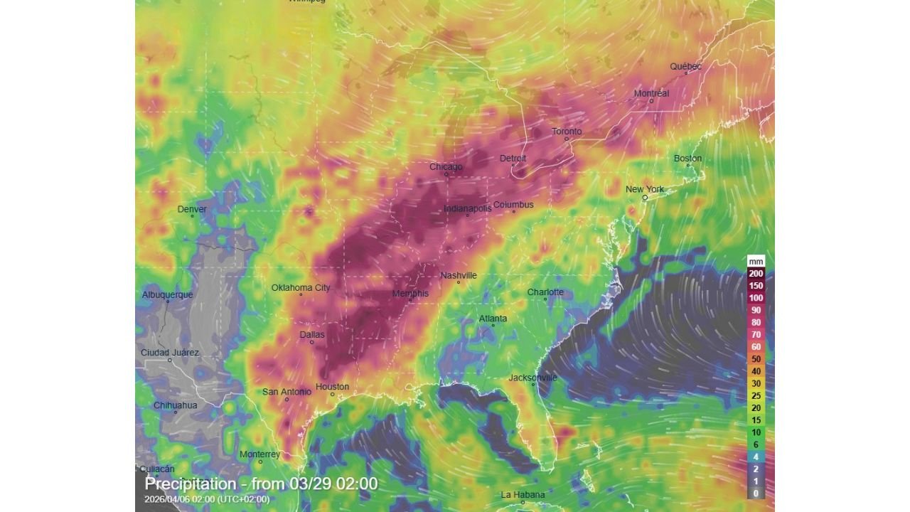
The precipitation forecast shown covers the period from March 29 through April 6, 2026.
Where the Heaviest Rain Is Expected
The rainfall map tells a striking story. A deep corridor of 150 to 200-plus millimeters — roughly 6 to 8-plus inches — of accumulated rainfall is forecast across the heart of the central United States, centered directly over Memphis, Nashville, Indianapolis, Columbus, and Chicago. This is the zone carrying the highest flooding concern over the next seven days.
Surrounding that core, a broad area of 100 to 150 millimeters — roughly 4 to 6 inches — covers Dallas, Houston, Oklahoma City, Detroit, and Cincinnati. Further out, 50 to 100 millimeters — roughly 2 to 4 inches — extends across Atlanta, Charlotte, Kansas City, and the broader Southeast and Ohio Valley.
The Atlantic coast from Jacksonville northward through New York and Boston sits on the lighter end of the forecast, with 20 to 50 millimeters expected across that corridor.
Rainfall Forecast by City — Seven-Day Totals
| City | Expected Rainfall |
|---|---|
| Memphis, TN | 150–200mm (6–8″+) |
| Indianapolis, IN | 150–200mm (6–8″+) |
| Columbus, OH | 150–200mm (6–8″+) |
| Chicago, IL | 150–200mm (6–8″+) |
| Nashville, TN | 150–200mm (6–8″+) |
| Dallas, TX | 100–150mm (4–6″) |
| Houston, TX | 100–150mm (4–6″) |
| Oklahoma City, OK | 100–150mm (4–6″) |
| Detroit, MI | 100–150mm (4–6″) |
| Cincinnati, OH | 100–150mm (4–6″) |
| Atlanta, GA | 50–100mm (2–4″) |
| Charlotte, NC | 50–100mm (2–4″) |
| Kansas City, MO | 50–100mm (2–4″) |
| New York, NY | 20–50mm (1–2″) |
| Boston, MA | 20–50mm (1–2″) |
| Jacksonville, FL | 20–50mm (1–2″) |
| Denver, CO | 10–25mm (under 1″) |
Why This Much Rain Is a Flooding Concern
Seven inches of rain falling over a single day would be an obvious flood emergency. Seven inches falling over seven days is less dramatic — but it carries its own serious risks that residents should not underestimate.
When multiple rounds of heavy rain fall over the same area across several days, the ground progressively loses its ability to absorb water. After the first two or three inches, soil saturation reaches a point where additional rainfall has nowhere to go except directly into drainage systems, streams, and rivers. River levels rise steadily with each passing rain event, and by late in the week, even a moderate rainfall rate can push already-swollen rivers over their banks.
The cities sitting in the 150 to 200mm corridor — Memphis, Nashville, Indianapolis, Columbus, and Chicago — face the highest cumulative flooding risk precisely because of this process. These are also cities with significant river systems running through them. The Mississippi, Ohio, Cumberland, and Illinois rivers all run through or near the heaviest rainfall zone and will be rising steadily through the week.
Forecast Confidence Level
High confidence on the overall heavy rainfall pattern across the central United States — multiple model runs are in agreement that Texas through the Mississippi Valley and into the Great Lakes will see significant accumulated rainfall through early April.
Medium confidence on exact city-level totals — the precise positioning of the heaviest rainfall bands will shift as individual storm systems move through the pattern. Cities near the edges of the deep purple zone could see notably higher or lower totals depending on storm track.
High confidence on flooding risk** — regardless of exact totals, the sustained multi-day nature of this rainfall pattern makes flooding a legitimate concern across the Mississippi Valley and Ohio Valley through April 6.
What Residents Across Affected States Must Do
Monitor river levels in your area starting now. If you live near a river, creek, or stream in the Memphis, Nashville, Indianapolis, Columbus, or Chicago area, check your local flood stage forecasts daily through the week. Rivers that are already running high from recent rains have less capacity to absorb additional inflow.
Do not drive through flooded roads under any circumstances. The most preventable flood fatalities happen when drivers attempt to cross water of unknown depth. Six inches of fast-moving water can knock a person down. Two feet can carry a vehicle away. When a road is flooded — turn around, do not drown.
Prepare your property for extended wet conditions. Clear gutters and downspouts before the rain begins. Make sure sump pumps are working. Move valuables out of basements and low-lying areas in flood-prone neighborhoods.
Residents in low-lying areas near the Mississippi and Ohio river systems should monitor National Weather Service river flood forecasts closely and know their evacuation routes before water starts rising.
Keep travel flexible through the week. Multiple rounds of heavy rain across the central United States will create hazardous driving conditions repeatedly through early April. Build extra time into any travel plans and avoid unnecessary road trips during the heaviest rain windows.
The Bottom Line
A significant seven-day heavy rainfall event is taking shape across the central and eastern United States from March 29 through April 6. The hardest-hit corridor — covering Memphis, Nashville, Indianapolis, Columbus, and Chicago — is forecast to receive 6 to 8-plus inches of accumulated rainfall, creating a genuine and growing flooding threat across the Mississippi Valley and Ohio Valley. Broader areas from Texas through the Southeast and into the Great Lakes will see 2 to 6 inches. This is a prolonged, multi-round rainfall pattern that demands attention — monitor your local forecasts daily and have a flood response plan in place before the heaviest rain arrives.
Stay ahead of dangerous weather before it reaches your door. Visit cabarrusweekly.com for daily flood alerts, heavy rain coverage, and storm updates from across the United States — because knowing early is the difference that matters.