Texas, Oklahoma, Arkansas, Tennessee, Kentucky, Virginia, and the Carolinas Brace for Widespread and Dangerous Ice Accumulation Through Sunday
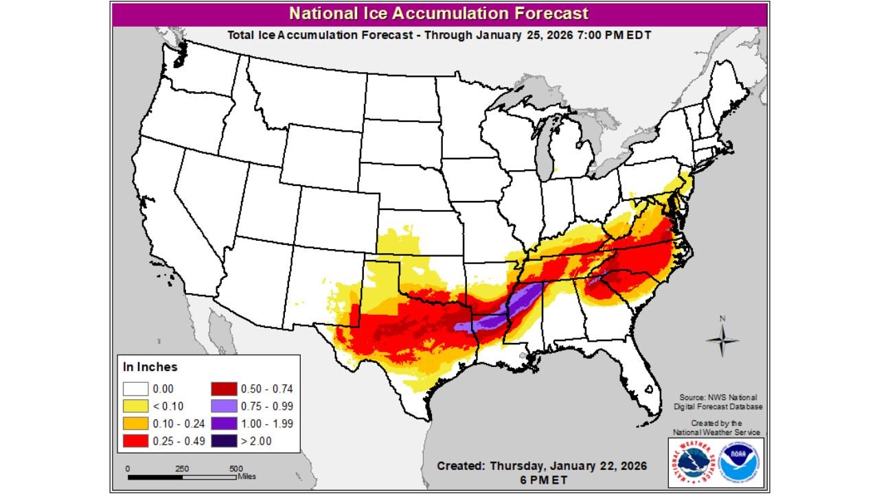
UNITED STATES — A major ice storm threat is taking shape across a broad swath of the country, stretching from Texas and the Southern Plains through the Tennessee Valley and into the Mid-Atlantic and Carolinas. National ice accumulation forecasts show significant freezing rain totals, with some areas at risk of three-quarters of an inch to more than one inch of ice, a level capable of causing widespread power outages and dangerous travel conditions.
A Long, Continuous Ice Corridor Is Developing
Forecast maps reveal a nearly continuous band of ice extending from:
- North and central Texas
- Across Oklahoma and Arkansas
- Through northern Mississippi, Tennessee, and Kentucky
- Into West Virginia, Virginia, North Carolina, and parts of the Mid-Atlantic
This setup is especially concerning because it is not a narrow stripe, but a wide zone with multiple impact levels layered across the region.
Where the Ice Will Be the Worst
Based on the forecast shading:
- 0.25 to 0.50 inches of ice (red areas): Widespread across much of Texas, Arkansas, Tennessee, and Virginia
- 0.75 to 1.00 inches (purple): Focused from eastern Texas through the lower Mississippi Valley into the central Appalachians
- Greater than 1 inch (dark purple): Isolated but extremely dangerous pockets, where tree damage and prolonged power outages are likely
Even lighter ice amounts can be dangerous, but once totals exceed 0.25 inches, impacts increase rapidly.
Why This Ice Event Is So Dangerous
This storm combines:
- Shallow Arctic air at the surface
- Warm air overrunning from the south aloft
- Prolonged precipitation duration
That combination favors freezing rain over sleet or snow, allowing ice to build continuously on trees, power lines, roads, and bridges rather than compacting or melting.
Expected Impacts
Residents across the ice corridor should prepare for:
- Extremely hazardous travel, especially on untreated roads
- Tree limbs snapping under ice weight
- Power outages, potentially long-lasting in hardest-hit areas
- Blocked roads from downed trees and lines
- Emergency response delays due to road conditions
This is the type of ice event where even staying off the roads may not eliminate risk, especially if power infrastructure is affected.
Timing and Duration
Ice accumulation is expected to increase steadily through the weekend, with the most dangerous conditions likely developing Friday night through Sunday, depending on location. Some areas may experience multiple rounds of freezing rain, compounding impacts.
What to Do Now
- Avoid travel if possible, especially during freezing rain
- Prepare for power outages (flashlights, batteries, backup heat plans)
- Charge devices and secure loose outdoor items
- Check on vulnerable neighbors, especially the elderly
Bottom Line
This is a lot of ice, spread across a huge portion of the eastern half of the United States. Even small forecast changes could shift the hardest-hit zones, but confidence is high that significant icing will occur somewhere within this corridor.
Cabarrus Weekly will continue closely monitoring this evolving ice storm and provide updates as warnings and advisories are refined.