Texas, Oklahoma, Arkansas, Tennessee, Kentucky, Virginia, North Carolina, and the Carolinas Enter a High-Risk Ice Storm Window as GFS and EURO Signal Dangerous Freezing Rain Friday Through Monday
UNITED STATES — Forecast confidence continues to increase that a significant and potentially dangerous ice storm will unfold from Texas through the Southeast and into the Mid-Atlantic between Friday and Monday, with both the GFS and EURO models showing widespread ice totals capable of causing major impacts. While the exact storm track remains uncertain, the risk envelope is large, and ice amounts shown are well above thresholds that historically lead to power outages and travel shutdowns.
Ice Accumulation Signals From GFS and EURO Models
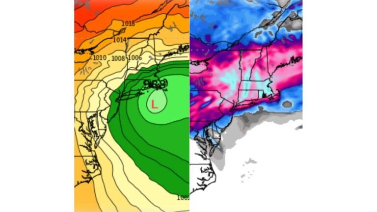
Latest Wednesday afternoon guidance from both the GFS and EURO models continues to advertise a long, continuous corridor of freezing rain stretching from North Texas across Arkansas, Tennessee, Kentucky, Virginia, and North Carolina.
Key ice thresholds to understand:
- 0.25 inches of ice often begins causing tree damage and scattered power outages
- 0.50 inches or more significantly increases the risk of widespread outages, impassable roads, and infrastructure damage
- Current model guidance shows large areas exceeding 0.50 inches, with localized totals approaching or exceeding 1.00 inch if the worst-case solutions verify
Core States at Highest Ice Risk
Based on the current placement of the freezing rain axis, the highest concern zone includes:
- Texas (especially North and Central Texas)
- Oklahoma
- Arkansas
- Tennessee
- Kentucky
- Virginia
- North Carolina
- Parts of South Carolina
This corridor sits south of the primary heavy snow band, where cold air is shallow near the surface, allowing liquid precipitation to freeze on contact.
Timing: A Long-Duration Ice Event
This is not a quick-hitting system. Current data supports:
- Onset: Late Friday
- Peak impacts: Saturday through Sunday
- Lingering effects: Into Monday as the system moves eastward
Long duration is a major concern, as repeated rounds of freezing rain can compound ice accumulation even if rates are light at times.
Snow vs Ice Boundary Still Uncertain
The exact north-south placement of the storm track remains unresolved, which is critical. A shift of 30–50 miles north or south could result in:
- Heavy snow instead of ice for some areas
- Cold rain instead of freezing rain for others
Recent GFS trends suggest a slightly more northern track into the Mid-Atlantic, which would expand snow risk northward but keep ice locked in across the Southeast and Carolinas.
Impacts Likely Even Without Worst-Case Totals
Even if the highest ice totals do not fully verify, the areal coverage alone is concerning.
Expected impacts include:
- Widespread power outages
- Downed trees and power lines
- Extremely hazardous travel conditions
- Extended recovery time due to Arctic cold behind the storm
Cold air following the system will limit melting, allowing ice to remain on roads and infrastructure for days.
Why This Storm Demands Attention Now
What separates this event from typical winter storms is the combination of:
- High moisture content
- Shallow but entrenched cold air
- Long duration
- Large geographic footprint
This is the type of setup historically associated with crippling ice storms, particularly across the Southeast and southern Mid-Atlantic.
Bottom Line
A dangerous ice storm is increasingly likely from Texas through North Carolina and into Virginia between Friday and Monday, with ice amounts already exceeding impact thresholds in forecast guidance. While exact placement will continue to be refined, preparations should not wait, especially in areas within the current ice corridor.
Residents should prepare for power outages, avoid unnecessary travel during peak icing, and monitor updates closely as confidence continues to increase. For continued analysis, regional breakdowns, and timing updates, stay with CabarrusWeekly.com.