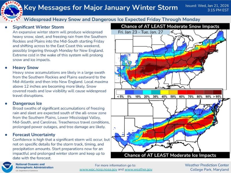
Texas, Oklahoma, Arkansas, Tennessee, Kentucky, Virginia, North Carolina, and the Mid-Atlantic Face a Prolonged Major January Winter Storm With Heavy Snow, Dangerous Ice, and Extreme Cold
UNITED STATES — A high-impact January winter storm is becoming increasingly likely from Friday through Monday, with dangerous ice accumulation, heavy snow, and prolonged travel and power disruptions expected across a wide swath of the country. Forecast confidence is high that a major storm will occur, though exact placement of the heaviest snow and ice remains uncertain, a critical factor for impacts.
Large-Scale Storm Setup and Timing
Forecast data shows an expansive storm system developing over the Southern Plains on Friday, then shifting eastward through the weekend into the Tennessee Valley, Appalachians, and East Coast, with impacts lingering into Monday and possibly early Tuesday in New England.
Extreme Arctic cold following the storm will prolong snow and ice impacts, especially in areas that experience power outages or untreated roads.
Heavy Snow Threat: Southern Plains to the Northeast
A broad swath of heavy snow is increasingly likely from parts of Texas and Oklahoma northeastward through Arkansas, Tennessee, Kentucky, Ohio, Pennsylvania, New York, and New England.
Key concerns include:
- Widespread snow-covered roads
- Low visibility during heavier snowfall
- Local snowfall totals potentially exceeding one foot in favored areas
- Extended travel disruptions well beyond the active snowfall
Dangerous Ice Zone South of the Snow Band
South of the primary snow corridor, significant freezing rain and sleet are expected, creating one of the most dangerous aspects of this storm.
The highest ice risk currently spans parts of:
- Texas and Oklahoma
- Arkansas and the Lower Mississippi Valley
- Tennessee Valley
- North Carolina, South Carolina, and parts of Virginia
Ice accumulation on trees, power lines, bridges, and roadways could result in:
- Prolonged power outages
- Tree damage
- Extremely hazardous travel conditions
- Emergency response challenges
Forecast Uncertainty Still a Major Factor
While confidence is high in a significant winter storm, uncertainty remains regarding:
- Exact storm track
- North-south placement of the snow-ice boundary
- Final precipitation amounts
Even a small shift of 30 to 50 miles could dramatically change impacts from heavy snow to crippling ice or cold rain for some communities.
Areas of Greatest Concern by Region
- Southern Plains: Early onset snow and ice beginning Friday
- Mid-South and Tennessee Valley: High risk for dangerous ice accumulation
- Appalachians and Mid-Atlantic: Heavy snow combined with icing potential
- Carolinas and Virginia: Elevated ice risk with prolonged power concerns
- Northeast: Snow increasing late weekend into early next week
Why This Storm Could Be Especially Disruptive
This system combines high moisture content with entrenched Arctic air, a setup that historically produces widespread, long-lasting impacts. Cold air lingering behind the storm means snow and ice may not melt quickly, compounding travel and infrastructure issues.
Bottom Line
A significant and potentially dangerous winter storm is likely from Texas to the East Coast, beginning Friday and lasting into Monday. Heavy snow, dangerous ice, and prolonged disruptions are all possible, with preparations strongly advised now due to forecast uncertainty and the storm’s expansive reach.
Residents across the impacted states should prepare for power outages, avoid unnecessary travel, and closely monitor local forecasts as details continue to evolve. For continued updates, regional breakdowns, and timeline refinements, stay with CabarrusWeekly.com.