Texas, Oklahoma, Kansas and Missouri Enter Stormy Mid-April Pattern as Jet Stream Fuels Repeated Severe Weather Threats
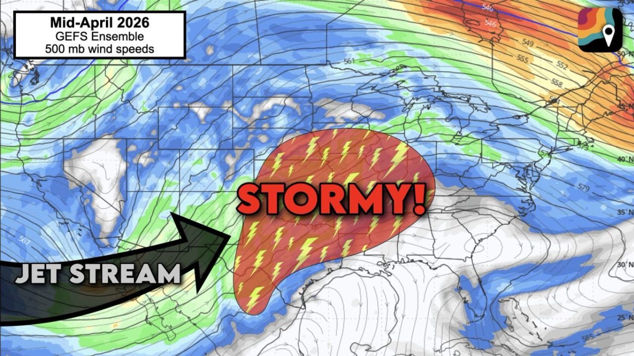
UNITED STATES — A significant mid-April weather pattern shift beginning around April 12 is expected to bring repeated rounds of severe weather across the central United States, particularly impacting Texas, Oklahoma, Kansas, and Missouri as a strong southwest flow sets up across the Plains.
Forecast data highlights a persistent jet stream pattern that will act as a trigger for multiple storm systems over several days.
Southwest Flow Pattern Sets the Stage for Severe Weather
The upcoming pattern is defined by:
- A persistent southwesterly flow aloft across the Plains
- Energy moving in from the western United States into the central region
- A favorable setup for storm development over the southern and central Plains
This type of pattern is well-known for producing:
- Repeated thunderstorm outbreaks
- Strong to severe storm systems forming in cycles
- Extended periods of unsettled weather rather than a single storm event
Surface Low Development Near the Rockies Increases Risk
As this pattern takes shape:
- Multiple surface low-pressure systems are expected to develop along the eastern slopes of the Rockies
- These systems will move into the Plains, pulling in warm, moist air from the Gulf of Mexico
- Each system creates a new opportunity for thunderstorm initiation and severe weather
This setup strongly supports:
- Large hail and damaging winds
- Potential for tornado-producing storms
- Heavy rainfall with localized flooding concerns
Storm Corridor Focused Across the Central U.S.
The most active zone appears to stretch from:
- North Texas and western Texas
- Through Oklahoma and Kansas
- Extending into parts of Missouri and the Mid-Mississippi Valley
This region sits directly under the active jet stream corridor, where:
- Upper-level winds enhance storm organization
- Instability and moisture combine to fuel stronger storms
The result is a “storm corridor” that may remain active for several consecutive days.
Jet Stream Alignment Plays a Critical Role
A key driver of this pattern is the jet stream positioning:
- The jet stream dips into the western U.S. and then lifts northeast across the Plains
- This creates strong upper-level wind support, essential for severe storm development
- The alignment allows storms to sustain and organize more efficiently
As long as this jet stream remains in place, new waves of storms can develop repeatedly.
What Makes This Pattern Notable
This is not a one-day event. Instead, the pattern suggests:
- Several consecutive days of severe weather potential
- A high-confidence setup for active conditions
- Increased likelihood of multiple storm rounds impacting the same regions
That raises concerns for:
- Cumulative rainfall totals
- Repeated severe weather impacts in the same areas
- Potential disruptions across multiple states
Timing and Outlook Moving Forward
The most active window begins:
- Around April 12 and continuing through mid-April
- With each passing day potentially bringing new storm chances across the Plains
While exact timing of individual storms will vary, the overall pattern strongly supports ongoing severe weather risks.
Stay With Cabarrus Weekly for Severe Weather Coverage
With a highly active and potentially dangerous weather pattern developing, residents across Texas, Oklahoma, Kansas, and Missouri should stay alert for updates.
Cabarrus Weekly will continue to track this evolving situation, providing timely updates on storm timing, severity, and impacted regions across the United States.