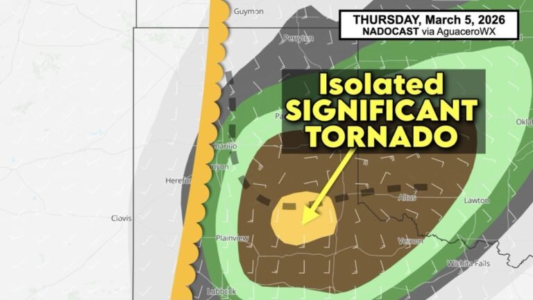
Texas, Oklahoma, Kansas, and Missouri Face Elevated Tornado Threat Wednesday April 1 With Very Large Hail and Damaging Winds as Discrete Supercells Target Dallas, Oklahoma City, Tulsa, Wichita, and Kansas City
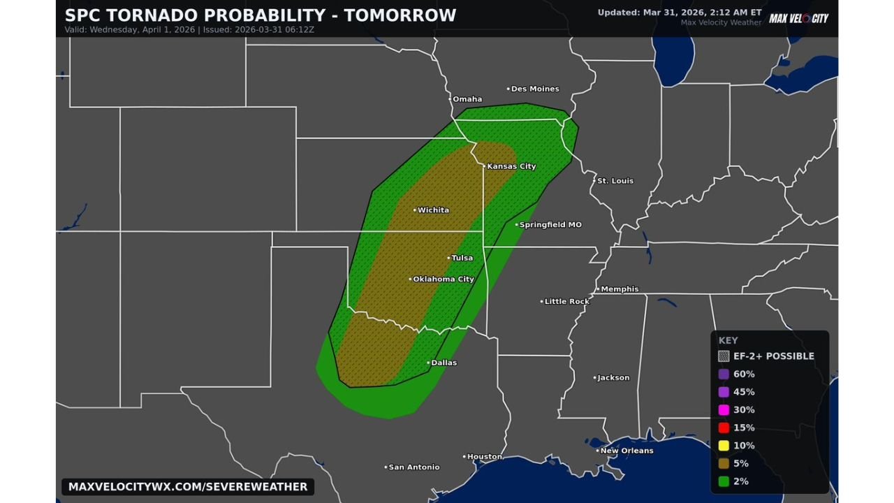
UNITED STATES — An elevated and serious tornado threat is locked in for Wednesday, April 1, 2026 across a corridor stretching from northern Texas through Oklahoma, Kansas, and into Missouri. The Storm Prediction Center tornado probability map shows a 10% tornado zone centered over some of the most populated cities in the southern Plains — including Dallas, Oklahoma City, Tulsa, Wichita, and Kansas City — with EF2 or stronger tornadoes possible across the entire risk area. Widespread storms firing late Wednesday afternoon are expected to remain as discrete supercells for an extended period — one of the most dangerous storm configurations for producing long-track, significant tornadoes.
This outlook was issued March 31, 2026 at 06:12z, updated at 2:12 AM ET, valid Wednesday, April 1, 2026.
Why Discrete Supercells Make This Setup More Dangerous
Not all tornado threats are created equal. The difference between a squall line producing brief spin-up tornadoes and discrete supercell thunderstorms maintaining their individual identity for an extended period is the difference between a minor tornado threat and a potentially significant outbreak.
When storms remain discrete — meaning they do not merge into a single line and instead maintain separate, organized circulations — each individual storm has access to its own dedicated inflow of warm, moist Gulf air. That uninterrupted fuel supply allows supercells to maintain their rotating updrafts for much longer periods, dramatically increasing the time window during which each storm can produce a tornado.
A supercell that remains discrete for two or three hours is capable of producing multiple tornadoes, potentially including long-track tornadoes that stay on the ground for many miles. Wednesday’s setup is specifically flagged for discrete supercell potential — which is why forecasters are treating this threat with elevated concern despite it being an early April event rather than the peak of tornado season.
The 10% Tornado Zone — Who Is Inside It
The core of Wednesday’s tornado threat — the 10% tornado probability zone with EF2+ significant tornado potential — is centered directly over a corridor running from northern Texas through central Oklahoma, eastern Kansas, and into western Missouri. The specific cities sitting inside or near this elevated core zone include:
| City | State | Risk Zone |
|---|---|---|
| Dallas | Texas | 10% / EF2+ |
| Oklahoma City | Oklahoma | 10% / EF2+ |
| Tulsa | Oklahoma | 10% / EF2+ |
| Wichita | Kansas | 10% / EF2+ |
| Kansas City | Kansas / Missouri | 10% / EF2+ |
| Springfield | Missouri | 5% / EF2+ |
| Omaha | Nebraska | 2% outer zone |
| Des Moines | Iowa | 2% outer zone |
| Little Rock | Arkansas | 2% outer zone |
Three Threats — Not Just Tornadoes
While tornadoes are the headline concern Wednesday, the severe weather threat across this corridor is not limited to rotation alone. Widespread storms firing late Wednesday afternoon will also be capable of producing:
Very large hail — Discrete supercells in an environment with this level of instability and moisture are capable of producing hailstones of two inches in diameter or larger — baseball size and beyond. Hail of this size causes significant damage to vehicles, roofs, windows, and crops. A single supercell hailstorm can cause millions of dollars in damage across a populated area.
Damaging straight-line winds — Even supercells that do not produce tornadoes can generate damaging outflow winds exceeding 70 to 80 mph as their downdrafts hit the surface and spread outward. These winds are capable of downing trees, snapping power lines, and causing structural damage across a wide swath of territory.
Isolated strong tornado — Beyond the general tornado threat, forecasters are specifically noting that an isolated strong tornado cannot be ruled out — meaning a single, particularly well-organized supercell could produce a tornado that stays on the ground for an extended period and reaches EF2 or stronger intensity.
Timing — When the Threat Peaks Wednesday
Late Afternoon — Storms begin firing along the dryline across northern Texas and Oklahoma. Supercell development initiates as instability builds during peak heating hours. Initial tornado and large hail threat window opens across Dallas, Oklahoma City, and Tulsa.
Evening Hours — The threat expands northward into Kansas and Missouri as storms track northeast. The discrete supercell mode is most likely to be maintained during this window. Kansas City and Wichita face their highest tornado probability during the evening hours as organized supercells move through.
Overnight — Low-level winds continue to strengthen overnight, maintaining the tornado threat into the late evening hours across Missouri and potentially into Arkansas and Iowa. The overnight window carries additional danger as visibility drops and residents may be less alert.
Forecast Confidence Level
High confidence on widespread severe storm development Wednesday afternoon and evening across Texas, Oklahoma, Kansas, and Missouri — instability, moisture, and upper-level dynamics are all well-established.
High confidence on very large hail threat** — the thermodynamic environment supports hailstones of two inches or larger with the strongest supercells.
High confidence on discrete supercell mode at least through the early evening hours** — wind shear profiles support organized, separated storm structures rather than a merged squall line through the peak threat window.
Medium confidence on exact tornado tracks and intensity** — while the overall threat is well-defined, the specific locations that see tornadoes cannot be precisely predicted at this range. Any location within the 10% zone should treat themselves as being in the primary threat area.
What Residents in Dallas, Oklahoma City, Tulsa, Wichita, and Kansas City Must Do Today
Finalize your tornado shelter plan before Wednesday afternoon. Every member of your household should know exactly where to go when a tornado warning is issued — a basement is the safest option, followed by an interior room on the lowest floor away from all windows. Do not wait until a warning is issued to figure this out.
Charge all devices and prepare a severe weather kit today. Power outages are likely with severe storms of this intensity. Keep phones fully charged, have a backup battery pack ready, and assemble a kit with water, flashlights, medications, and important documents before Wednesday morning.
Do not rely solely on outdoor sirens for tornado warnings. Sirens are designed to alert people who are outside — they are not reliable inside a building with windows closed, and they are completely ineffective if you are asleep. Enable Wireless Emergency Alerts on your phone and consider a battery-powered weather radio as a backup.
If you live in a mobile home or manufactured housing anywhere within the 10% or 5% tornado probability zone, make arrangements now to shelter in a nearby sturdy building Wednesday evening. Mobile homes offer virtually no protection against even a weak tornado.
Avoid unnecessary travel Wednesday afternoon and evening across the Dallas to Kansas City corridor. Being on the road during an active tornado warning is one of the most dangerous positions to be in during a severe weather event.
Check on vulnerable neighbors — elderly residents, those with disabilities, and anyone without a reliable severe weather alert system in the risk zone deserve a check-in before Wednesday afternoon.
The Bottom Line
Texas, Oklahoma, Kansas, and Missouri face a serious and elevated tornado threat Wednesday, April 1. A 10% tornado probability with EF2+ significant tornado potential covers a corridor from Dallas through Oklahoma City, Tulsa, Wichita, and Kansas City. Discrete supercells maintaining their organization for an extended period create the most dangerous tornado-producing environment of the spring season so far across the southern Plains. Very large hail and damaging winds are additional threats with every storm in the risk zone. The threat peaks Wednesday late afternoon through the overnight hours — residents across the entire risk corridor must have shelter plans finalized, alert systems active, and be prepared to act immediately when warnings are issued.
Stay ahead of dangerous weather before it reaches your door. Visit cabarrusweekly.com for daily tornado outlooks, severe weather coverage, and storm alerts from across the United States — because knowing early is the difference that matters.