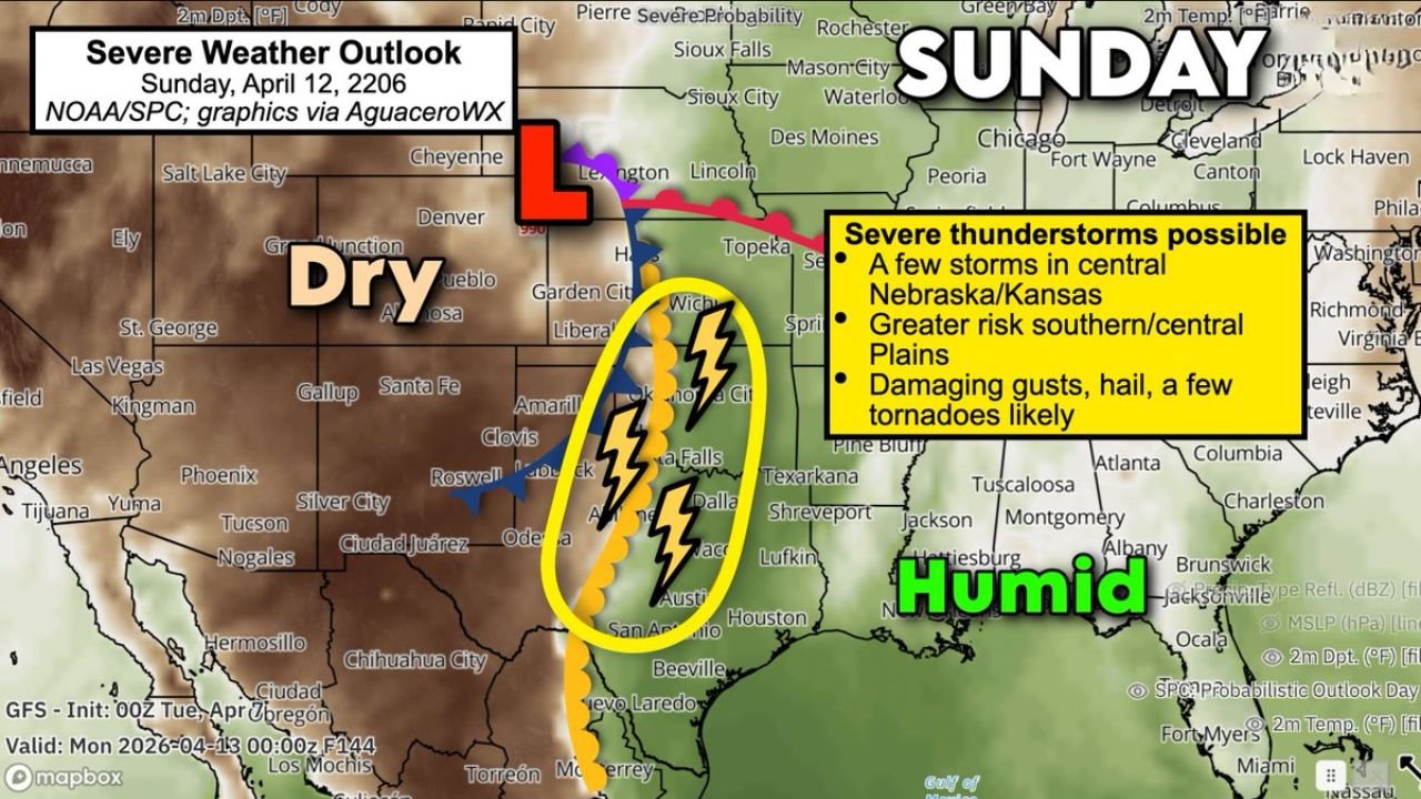
Texas, Oklahoma, Kansas and Nebraska Brace for April 12 Severe Storm Threat as Supercells, Hail and Tornadoes Become Likely
TEXAS — A more organized and potentially dangerous severe weather setup is expected to unfold on Sunday, April 12, with conditions aligning across the central and southern Plains for strong to severe thunderstorms, including possible tornadoes.
Forecast data indicates that this system could become one of the more notable severe weather days in this developing mid-April pattern.
Low Pressure Setup Pulls Moist Gulf Air Northward
The driving force behind this event will be a developing low-pressure system centered near the Nebraska Sand Hills, which will:
- Pull warm, humid air from the Gulf of Mexico northward
- Increase atmospheric instability across Texas, Oklahoma, Kansas, and into Nebraska
- Create a volatile environment capable of supporting strong storm development
This surge of moisture will act as fuel for thunderstorms, especially during the afternoon and evening hours.
Dryline and Cold Front to Trigger Storm Development
A key ingredient in this setup is the presence of a dryline and advancing cold front, which will:
- Separate dry air to the west from humid air to the east
- Act as the primary trigger for storm initiation Sunday afternoon
- Focus storm development from central Texas through Oklahoma into Kansas
As storms form along this boundary, they are expected to intensify quickly given the unstable environment.
Supercells Possible with Rotating Storms
Wind patterns changing with height — known as wind shear — will play a major role in storm structure:
- Some storms may evolve into rotating supercells
- These storms are capable of producing more intense and longer-lasting severe weather
- The threat zone may extend from central Texas northward into central Kansas and possibly Nebraska
This setup raises concerns beyond ordinary thunderstorms, pointing toward organized severe weather potential.
Primary Threats: Damaging Winds, Large Hail and Tornadoes
The current outlook highlights several key hazards:
- Damaging wind gusts capable of causing structural damage and power outages
- Large hail, potentially significant in stronger storms
- A few tornadoes, especially with any sustained supercell development
Forecast guidance suggests that at least a couple of tornadoes are possible, particularly in areas where storm rotation becomes established.
Risk Area May Expand in Coming Days
The Storm Prediction Center has already outlined a Level 2 (Slight Risk) for severe weather, covering parts of:
- Texas
- Oklahoma
- Kansas
- Nebraska (especially central areas)
There is a strong possibility that this risk area could expand or intensify northward as confidence in the setup increases closer to the event.
Central Plains in the Bullseye
While isolated storms may develop farther north into Nebraska, the greatest concentration of severe weather is expected across the southern and central Plains, including:
- Dallas–Fort Worth region
- Oklahoma City and surrounding areas
- Wichita and central Kansas
These areas sit directly along the corridor where moisture, instability, and storm triggers align most effectively.
Forecast Still Evolving Through the Week
While confidence is growing in a significant severe weather event:
- Exact storm timing and placement will become clearer in the coming days
- Small shifts in the setup could change which areas see the highest impacts
- Additional updates are expected as models refine the details
Stay With Cabarrus Weekly for Severe Weather Updates
Cabarrus Weekly will continue tracking this developing storm system and provide updates on risk levels, timing, and impacted regions.
Residents across the Plains should begin reviewing severe weather safety plans now, as Sunday’s setup has the potential to bring multiple hazards across a large region.